Justin Hays
Enthusiast
My first post seems to be taking the form of a general question, and something of a "trial" REPORT. Thanks for having me.
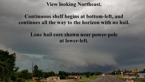
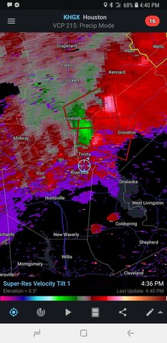
Last week I chased a moderately organized MCS-like line of storms on 1MAY2021 near Trinity, TX (Southeast TX) under conditions of 1). An approaching frontal boundary 2). Moisture saturation at the surface 3). "Some" upper-level diffluence to drive things home. 0-3km EHI as reported by NWS was "2-3" with MLCAPE of 2.5kJ/kg.
Quick confession: I've chased for a very long damn time, but due to the coastal location I've not seen much. When I encountered the structure in the picture I was a little overwhelmed and wasn't able to think rationally before my F-150 was overwhelmed by the core... So... I could be mistaking an outflow structure (Shelf or Pannus) for something more appeasing to my confirmation bias. Odd though, is that it has an adjacent hail core. Also odd is that radar-indicated vorticity was exactly correlated with the structure. Also there was a confirmed tornado sighting a little earlier and a little Northwest.
Can we discuss visual variations in such leading-edge boundaries? As the shelf cloud scrawls a line across your horizon and meets the area of an embedded mesocyclone, are there characteristic patterns or discontinuities that you've noticed? How does the otherwise-consistent wall of heavy rain change? Might the existence of a lone hail-core in a long line of heavy rain, indicate a cell of stronger inflow relative to the rest of the line? Radar-indicated bowing-lines are recognizable, but what would it look like if you were to drive parallel...would you drive past a linear shelf cloud to find an inflow-base oddly jutting out?
Thanks!!!