FAQ: Chasing the Southwestern Monsoon

The "orange circle" (lightning maximum) between Denver and Colorado Springs is likely associated with thunderstorms triggered by the mountain/plains wind circulation around Pike's Peak and the Palmer Divide.

The blue lightning minimum area over southcentral Colorado is located within the San Luis Valley. It makes sense that this valley is a local minimum when you consider that most of their lightning is triggered by the valley wind (breeze) circulation. This circulation favors lightning over the mountains and mountain slopes with a minimum over the valleys.

In "Mountain Meterology-Fundamentals and Applications" by C. David Whiteman...suggests that terrain related convergence zones trigger storms on day to day basis in the same mountainous areas in Colorado.

Terrain forced mechanisms include orographic lifting, channeling and lee side convergence. Terrain convective mechanisms include convection over surface with low albedos(snow vs rock/sunny side/shady side), upslope flow convergence and convergence displacement.

There is a map that shows thunderstorm initiation density contours for Colorado with Pikes Peak, the Wet Mountains, Sangres De Cristo Range(the most), and the Front Range WSW of Denver being the primary hot spots.

I would think with Pike's Peak placement..large isolated peak on the Front range...would cause lee side convergence of mid level westerly flow on the East side of the peak as wind flow goes just to the North and South of the peak..where it would often encounter low-level upslope flow. "Channeling flow" up the narrow valleys help not to mention that convection would have a higher tendency to maintain itself as it drifts off the mountains ENE in the vicinity of the high terrain associated with the Palmer divide and the convergence that is often present there.
 
Last edited by a moderator:

That's a very interesting map. I've seen similar, but not with such high resolution.

That map really shows the influence of Gulf moisture behind most of the US' lightning. It's also interesting to see the northern and western Plains having significantly less activity than farther east, and western West Virginia totaling as many strikes as Arizona and New Mexico! I really don't have it so bad over here.

If you're wanting to go where the lightning is, the Gulf Coast and Florida is always it. I think southern and coastal LA, MS and AL are probably underrated lightning photography hotspots - just looking at the work from chasers there like Johnny Autery and Terry Pallister says it all.
 
I have never chased Florida but I understand that although the lightning happens often, it is harder to see due to lower clouds/mistier conditions. Am I correct/incorrect? I don't know; I do see some great lightning photos coming from Florida. Often they are over the ocean.

The crazy terrain/canyon country, mesas, and jagged mtns of the Southwest are a big plus in lightning photography. High cloud bases help the lightning to be visible too, and most bolts are heavily branched. However the finicky Monsoon can make chasing the Southwest challenging, with many miles driven. It also has a shorter season than Florida. AZ's is July-early Sept. I have been making the most of it; just got back from my 4th trip to the Central Deserts this week. Pattern is very active; those 4 trips netted 3 scores, so I'm pleased about that. (a score in my book is catching the storm and successfully photographing it; and having at least one serious keeper).
 
Last edited by a moderator:
I'm heading to Florida for a week today, so I'll let you know how it goes. :) I'm hoping to get some "over the ocean" type of lightning strikes. Wish me luck!

James
 
Yes good luck! Pls share your impression of Florida chasing when you get the chance. Have an awesome time!
Start a Florida chase thread when you return? I'm sure many would love the 411.
 
Talk about a burst pattern. Is anyone else chasing the never-ending storm machine that has been the Arizona monsoon this week?

Tonight will be my 5th trip to the Central Deserts since Sunday. I might need to sleep eventually! Drying predicted for next week...maybe I'll catch up then. But who knows...

Curious what other monsoon-chasers are seeing.
 
A few little local news bites to share about lastnight's (Thurs 08/07/08) monsoon storm in Phoenix, Arizona. This is pretty typical.

15,000 customers were w/o power during peak of storm; 375 homes still dark

West Valley of Phoenix - 70 powerlines down

Street-flooding due to heavy downpours

1 roof taken

Trees uprooted pretty much all over town

Massive desert haboob, that was a big feature

Airport was closed; some flights rerouted to Vegas.

It was quite an event Thursday night.

What I did with it - chase the sandstorm wall at sunset (pics being scanned); then stayed on Central Deserts lightning storms for another 3 hours.

PS: gas pumps go down when towns lose power. Even though I had plenty after the sandstorm, I wanted to top off. Could not do so at main station in Maricopa; town had intermittent power. Had to find another station later. This would have been a big deal if I had been low. A lot of land out there between services.
 
Last edited by a moderator:
I'm just starting to get '08 pictures back and have my slides scanned.

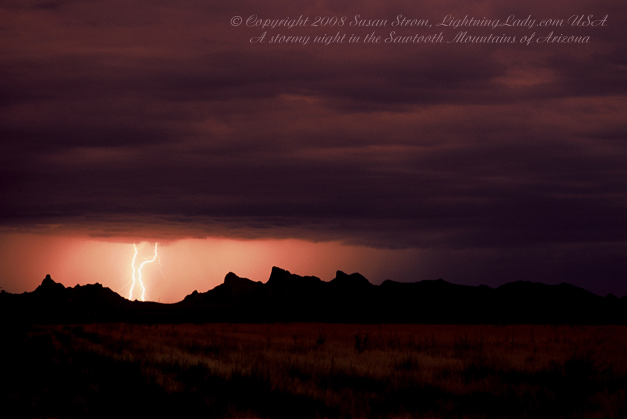
I remark about the "Central Deserts" of Arizona a lot. This is what the Central Deserts look like from one of my little spots down there.

Where are the Central Deserts? They include a vast expanse of Sonoran Desert in the south central part of the State between Phoenix and Tucson.

Some of the "Central Deserts" towns are Maricopa, Sacaton, Eloy, Casa Grande, Picacho, Arizona City, all of which are pretty small towns with the exception of CG (love the initials) which is growing. There is still a lot of land between services so plenty of gas is advised. There are services along I-10, part of which is a major artery of travel through the Central Deserts.

The Central Deserts are capable of producing oppressive heat and sun. Since towns are far between, there is no urban heat island. Summer storminess can be generous.

A lot of people don't know this, but a very small Civil War battle was fought in the Central Deserts, near a mountain called Picacho Peak (not far from the range below).

Mountain ranges in the Central Deserts can be jagged, rising abruptly from desert floor, and are typically covered in Saguaro cacti, Ironwood trees and Palo Verde.

This range, called the Sawtooth Mountains, under severe weather can look a bit like a place where ghosts would wander. Either that or Martians :)

The Arizona desert is capable of creating some really weird colors, especially when storm clouds are around. My pics are undoctored. In this case, the sun had just set under a cloud deck that made everything look funny, almost like sepia. That happens sometimes. Sand in the air can add a wine-colored cast; don't be surprised if that happens in your photos when sand is aloft. I don't edit it out; it is natural.

Other times, mountains (usually toward the east) can turn a bright ruby/purple color, if only for an instant. For photographers, watch for times when the sun sets under a deck of stratus. This bounces light around and can make mountains look purple just for a few moments. Doesn't happen every day but it is nice when it does. Let me see if I can dig up a past example of this: http://www.lightninglady.com/photos/StromLostDutch.jpg
Arizona's color palette, especially when stormy, can be pretty weird. Best chance to see would be late day into evening, in partly cloudy or stormy conditions.

This is a Monsoon storm from Sun Aug 3 '08 that rolled over the Sawtooths, hitting the tops of the mountains. The Sawtooths are a bit of a storm magnet. I go back there a lot; I love the shapes of the desert mountains and the moods of different lighting conditions.


StromDarkBeauty.jpg
 
Last edited by a moderator:
Mister Sandman bring me a dream...

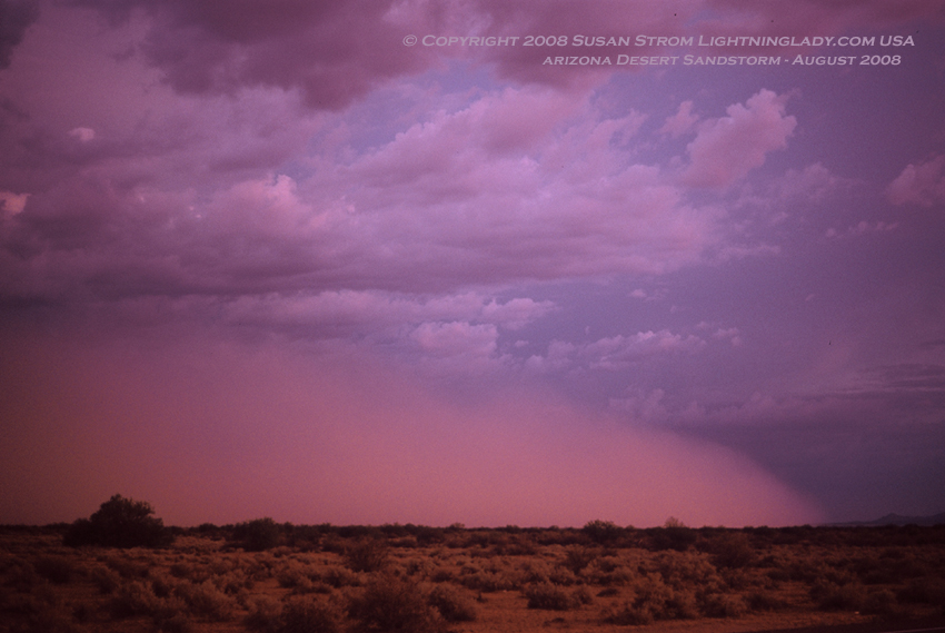
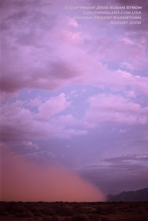
Caught a sandstorm (haboob) last week in the Central Deserts. The closest town would be Maricopa and the Gila River Indian Community, although this was out in the open desert on a nice road that was kind of a dream actually.

Sandstorms in Arizona form when a thunderstorm dies out and the sinking air fans out a sand wall in all directions.

They're pretty dramatic as they approach. I just let them pass over me, and be careful of the gusty winds, blowing debris, and decreased visibility. I also put eyewear on so the sand doesn't get in them and sometimes put a scarf over mouth depending on how thick it is.

They are fun to chase. I like to get right up to the edge, let it roll over me, then drive out of it and do it again.

StromMaricopaHabH.jpg
 
Photogenic sandstorms only occur a few times each summer. I usually only have a few chances, and when I do, commonly it is in the wide open Central Deserts areas as opposed to foothills and mountains.
 
Good job on the photos Susan! Looking forward to seeing more of these great shots.
 
Thanks! I hope that anyone chasing Monsoon has a chance to see the sand roll across the desert sometime. It would take a stroke of luck but they are fun when they happen.
 
A little action out there right now-I love this part-

* AT 505 PM MST...A TRAINED WEATHER SPOTTER NEAR ROOSEVELT REPORTED AN INCH OF RAIN IN 15 MINUTES. THIS INTENSE RAINFALL WILL LIKELY LEAD TO FLASH FLOODING OF AREA WASHES...

**

What does "localized heavy rainfall" with the Monsoon look like? It comes in pockets, where it will be a deluge in one area and no rain falling in another.
Here is an example from last summer of what that kind of rainfall looks like:
http://www.lightninglady.com/photos/StromTorrent.jpg


Gotta go! :)
 
Excellent writeup, Susan... I am stickying this thread so that it will be available as a permanent reference.

Tim
 
Back
Top