Could Joaquin be a threat to the Bahamas and the East Coast?

Should the Northeast be concerned about Joaquin?

  • Yes

    Votes: 5 45.5%
  • No

    Votes: 6 54.5%

  • Total voters
    11
With the 01/12Z models in, the HWRF has now flipped to the offshore solution, leaving CMC/GFDL with tracks into the outer banks and GFS/EURO/HWRF far offshore. Still plenty of disagreement/uncertainty.
 
What effect does the cutoff low have on the hurricane?

Sent from my SCH-I545 using Tapatalk

I really know very little about tropical weather but I would think that this trough is going to swing down into Florida at just the right time and and push the storm out to sea and away from the coastal regions of the southeast. If this trough weren't swinging through right now I imagine that Joaquin would just ride the trade winds and slam into Florida somewhere, or possibly even enter the Gulf.
 
What effect does the cutoff low have on the hurricane?

Sent from my SCH-I545 using Tapatalk


The thought was that the trough would "capture" the hurricane and help bring it in northwest toward the coast - envision it moving counterclockwise up and around the cutoff low - I think this is known as a fujiwara effect. But I am not sure what makes the difference between this occurring, OR the trough instead kicking the hurricane offshore as Mike suggested. I assume it has something to do with the exact timing/phasing and position/orientation of each feature when the trough and hurricane are close enough to each other to interact.
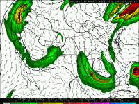
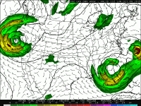
I am no expert either, just passing along the impression I got from reading the applicable PhillyWx.net thread, but my understanding is at best inadequate and at worst incorrect


Sent from my iPad using Tapatalk HD
 
With the 01/12Z models in, the HWRF has now flipped to the offshore solution, leaving CMC/GFDL with tracks into the outer banks and GFS/EURO/HWRF far offshore. Still plenty of disagreement/uncertainty.


Yep. Like I said in the post just above yours, there's almost no way this is an event that I will get to experience along the NJ coast. It's as if the NHC track is between the two likely solutions, with no actual chance of being itself a viable solution. Probably a poor metaphor, but almost seems like a coin flip that could be heads or tails, so let's just officially predict that the coin is going to land on its edge and stand vertically.


Sent from my iPad using Tapatalk HD
 
The thought was that the trough would "capture" the hurricane and help bring it in northwest toward the coast - envision it moving counterclockwise up and around the cutoff low - I think this is known as a fujiwara effect. But I am not sure what makes the difference between this occurring, OR the trough instead kicking the hurricane offshore as Mike suggested. I assume it has something to do with the exact timing/phasing and position/orientation of each feature when the trough and hurricane are close enough to each other to interact.
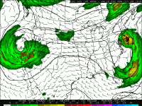
Yes, I agree, I think timing is everything. If you look at previous model runs of the GFS, you can see this capturing of the Hurricane by the trough.

64b759b196dbeef30f38515892171874.gif
8f5d6d109f3509e5eff7bc6269feeca6.gif
1a83ecd80db384a2975e0112ce35f74c.gif

This solution could have been pretty bad for the northeast, although the storm would be in a much weaker state than it is now by the time it made landfall. I guess it is still not impossible for this track to verify, but it is looking more likely that the trough timing and interaction with the storm will be perfect for residents cheering against landfall.
 
From what I can see of the spaghetti maps, there is almost no chance that the storm follows anything close to the official NHC track - it either makes landfall in the Carolinas OR goes OTS.


Sent from my iPhone using Tapatalk
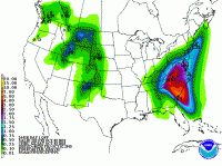

Generally speaking, the NHC official track is a combination of several of the computer models. Had it been any other model besides the GFS, CMC, NAM or Euro that was the outlier, it would likely have been disregarded. However, the Euro is better at handling tropical systems while the GFS is better at handling mid-latitude systems. The CMC tends to be too aggressive with tropical systems as well.
 
0e0384c8a33fb94bd571936d67ea9229.gif


This is over 24 hours. Very dangerous flooding situation going on in Charleston! VA and NC's mountains might get a lot of rain so it'll be dangerous to be out driving. Rough surf and rip currents are also possible along much of the east coast too and there are high wind warnings in southern Delaware and southeastern new jersey.
 
I am not sure why the NAM is not a reliable model for tropical systems, or maybe it is just an outlier for this particular system, but it's funny to look at how much different of a solution that it has. It has Joaquin just meandering around off the southeastern coastline for awhile, and basically eating up the southeastern US trough. This would be pretty awesome to see, but it won't happen... Does anyone know much about the models and their relationships/track records with tropical weather?
 
Last edited:
The NAM is not a global model and it was not developed to do tropical systems. It's like asking a quarterback to become a lineman. Both involve football - but their areas of expertise are too different to be of use :)
 
Back
Top