Chase Case #6 - these are getting tougher

Joined
Dec 8, 2003
Messages
2,208
Location
Kansas City, Missouri
Ok - it's time to make these a little tougher to figure out. So go to it.

We are starting with 12z analysis.

1. This is a possible chase event or a possible bust.

2. This event/non-event may have occurred anywhere on the maps provided.

3. This event/non-event may have occurred at any time.

---------------------------

The first person that successfully does any of the following wins:

1. Successfully names a specific target that produced a tornado;

2. Successfully describes the factors that played into a bust;

3. Succesfully provides a date for this event;

or

4. Successfully describes the solution for this day ...

--------------------------------------

12zsfc.gif


12z850.gif


12z500.gif


12z250.gif


Have fun ... and bickering (within the limits of TOS) is allowed this time, as long as you figure it out.
 
Since this is pretend, I was up late the night before and, anticipating a chase, left hours before this data became available. I'm driving to Terre Haute, IN, where I'll hang out and wait for new data to become available.
 
Well this certainly looks a lil tougher Mike.

Brief reasoning: For a 12z obs, temperautres/dewpoints are awfully high across much of the eastern part of the country - look at all those fog obs. Looks to me that there is good moisture in place all the way up to 850mb across the entire said area. We have that disturbance poised over the upper NW Plains on the 500mb map, with the associated jet dipping down into parts of Colorado/Kansas/Nebraska extending NNE into Canada (note of the 85-100kts max). Looking at the MO/IL/IN area, especailly over MO - we have pretty good directional sheer (sfc winds roughly 5-10kts at 185, 35-40kts at 225-230 at 850mb).

Target: Think i'll sit somewhere around extreme eastcentral MO/westcentral IL for the time being; St. Loius maybe for those that want a city.
 
Looks like mid-late May some year and I can't ignore that serious moisture in the southern plains(18/18 at 850 at dfw). I'm going to a place in far ne OK I think. I'm hoping with that serious jet diving down in the mountains there will be a nice sfc low form and move ne into OK(seems like a circulation at 850 is already trying to form in nc TX). So yeah, extreme ne OK and likely heading into the ozarks. I'm sooooo lost without models!

The positive tiltness to it says maybe stay home, but perhaps with that strong jet plowing south on the backside it is going to try and come out more neutral.

I'm actually starting to think this is a big tornado day too. Looks like cold 500 temps are going to rapidly overspread those crazy morning temps and dews...while a nice area of divergence atops this as well(yes I know it is convergent right now).
 
Haven't got much time for this one :( 
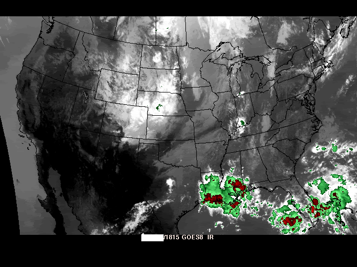
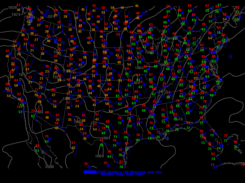
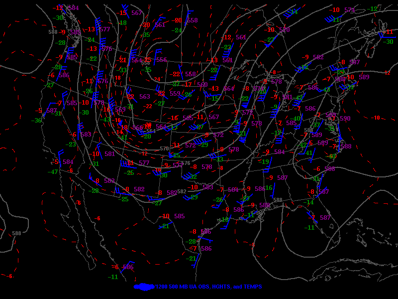
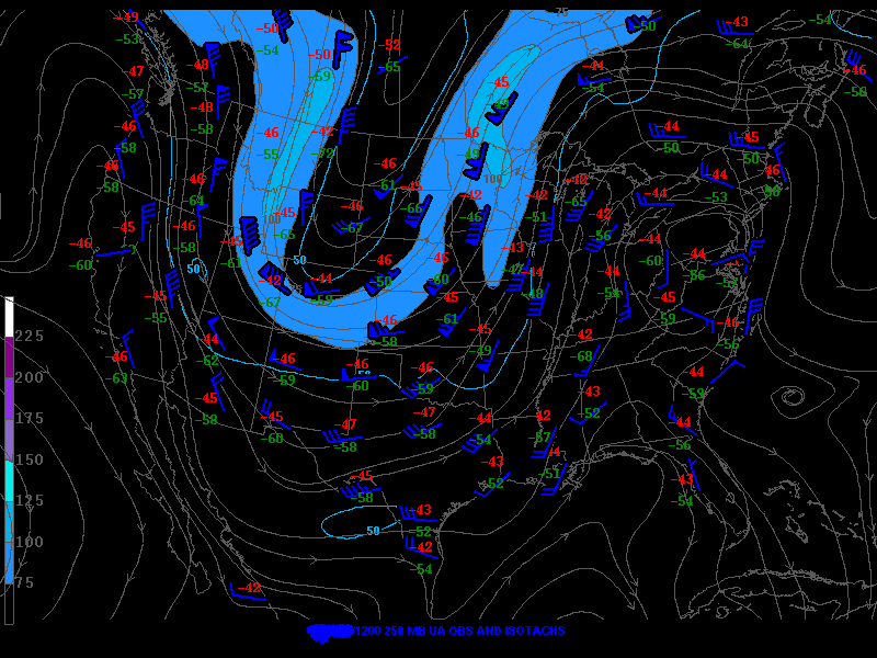
. The upper Midwest is an obvious choice, but it look like a pretty respectable traditional dryline-driven setup for eastern OK. I'll just drive to Muskogee, OK and see what develops. Plenty of moisture, no deal-breakers in the upper winds and a little upper-air cold advection to maybe kick things off.
 
Need more data to go in depth but at this point y general target is somewhere in the uper midwest. (will narrow it down later when I get more data) looks like moisture is plenty abundant that far north, nice surface low in the area. Shortwave across Iowa should push northeast into target area and make things interesting. Not much backing wind at this point but that could change.

Will go more in depth as more dats comes out.
 
What I like:
--moderately strong flow at all levels
--high magnitude of moisture (Tds in the 60s and 70s)
--insolation in advance of s/w trof at 500 mb

What I don't like:
--backed winds at 250 mb (which would suggest some problems with storms seeding each other and organizing into an MCS).
--positive tilt trough (thus limited strengthening of lee trough which would lead to small directional shear and potential for MCS development)

I'm going to say that storm mode was probably a problem on this day, with discrete storms quickly coalescing into a squall line.

Target: Cedar Rapids, IA
 
I believe I’ll set up in Jonesboro, AR. There is a well saturated boundary layer with backing winds, and the upper level disturbances should be rotating there.
 
I'll never be able to forecast from a few upper air maps and a satellite so I'll just guess the date: October 24, 2001
 
I'm going to aim for southern Wisconsin on this one, perhaps along the Iowa border. From the looks of the IR image, the incipent cyclone developing along the surface trough (correlated by the westward-directed moisture plume at 850 mb) has strengthened considerably by 18Z, with the attendant surface dryline extending back tot he southwest. However, as the 500 millibar jet overspreads the region and combines with strong ageostrophic curvature divergence near the inflection point of the 250 mb contours, these should contribute to rapid development (too rapid) along the surface boundary. The 250 mb trouhg, however, appears to be a bit too amplified for a supercell case. I would prefer a more gentle, perhaps weakly positively tilted UL trof to see a good severe weather episode. Early on in their lifespan the storms probably produced at least a few small tornadoes (most likely northeast of the surface low in the region of strongest low-level backing) along with a lot of hail, but rapidly congealed into a squall line which backbuilt along the surface boundary.

It smacks of linear high-risk wind event bustola.
 
I think I'll move slightly ENE from my central IL position... From the IR imagery, it looks like there is quite a bit of low level clouds further west. There also looks like there could be a cell, or cluster of cells, firing in northern IN / southwestern lower MI, which makes me more confident that something will / would be happening soon.

It sure is tough forecasting on only sparse analysis data...
 
Back
Top