Chase Case #6 - these are getting tougher

I agree with rdewey's ENE push. Going off the IR and the soundings (LZK, FWD, and DTX) DTX looks to be the only one with both CAPE and shear/helicity.

I'll contine my eastward push across central MO and reposition on the central IN/IL border - possibly Lafayette IN.
 
Yeah, I'm gonna hold my position based on the soundings. ILX doesn't really appeal to me with the lack of directional shear and instability. Better shear is present towards DTX, but overall lapse rates are pretty weak... Hopefully the shortwave will be enough to spark something near my position...

The only sounding that does appeal to me on that list is FWD... They have nearly 5000J/KG of CAPE with decent directional shear (though speed shear looks crappy). The SFC data also showed nice moisture pooling, while data from 700MB showed a dry slot that could act as a boundary depending on how it hangs around... Then again, there appears to be some upper level speed convergence at 250MB which may keep things quiet in that area.

Mike, you sure did pick a tough one! :lol:
 
Look at the flow aloft(say between 250 and 400mb) on the LZK and SGF soundings...note the difference between the two. SGF has basically south flow aloft while LZK just to its south has more westerly flow. Wonder if there is nice jet plowing in west of there now as it is rather divergent now. OUN has 55 knots out of the sw just above 500mb now. Yeah I'll stay with far ne OK and hope my sfc is somewhat sane at this point...it should be.
 
Sat2.gif


0zSfc.gif
 
I hope I got on my ne OK supercell early and am chasing it across northern AR now. While I'm doing this I'm hoping to god there isn't some deviant monster dropping south in c TX(making up for the lack of shear).

I'm missing Jarrell TX ain't I?

Cool, just looked and I shouldn't be missing Jarrell anyway.
 
looks like a line of cu trailing southwest into north central texas from that cell in southeast oklahoma. I should of targeted Denton Texas :cry:
 
LOL, Mike you erased the Wx symbol at McAlester... wonder if that was a hint ;-)

I was kind of eyeing the I-20 corridor just west of the D/FW metroplex initially with entrance region of upper jet in region of +18C h85 dews.. So, my target is ~20 W FTW for tail end charlie... with options to blast to the Red River if Cu doesn't develop pretty soon (virtual time is 2030 utc)
 
LOL - ok, with U's post, it's time to reveal ... (yeah, you caught me ... I tried my best to hide the thunderstorm symbol ... pesky things) ...

----------------------------------------------

Here's your solution:

http://www.spc.noaa.gov/climo/reports/010908_rpts.html

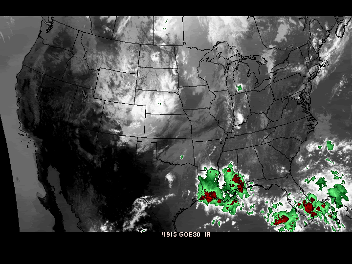
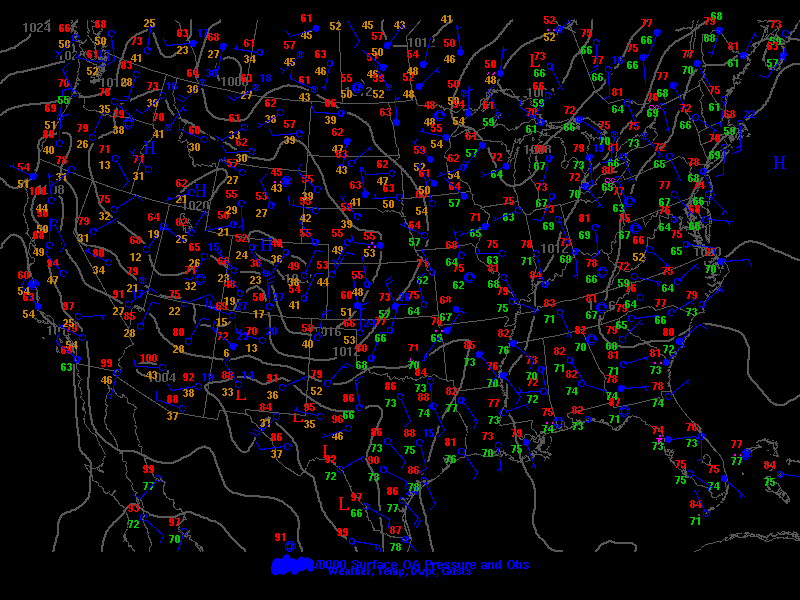
The date was September 8, 2001, a date in which any weather news was quickly eclipsed by the events of 9/11 a couple days later. The day resulted primarily in a widespread squall line/bow echo event that caused wind and hail damage for the most part, with some tornado reports in central Texas in the Tail End Charlie cells.

From Eric Nguyen's chase account that day:

SAW A ROTATING STORM IN YOUNG COUNTY, TX. NICE STRUCTURE FOR ABOUT 45 MIN. HAD PRONOUNCED INFLOW BANDING AND BEAVER TAIL FOR A WHILE. ALSO HAD A NICE ROUND BASE AND SOME STRIATIONS. WITNESSED A PERSISTENT MID-LEVEL FUNNEL COMING OFF THE NORTH SIDE OF THE STORM. STORM EVENTUALLY WEAKENED AN HOUR LATER. ON MY WAY HOME I SAW LIGHTNING STRIKE A TRANSFORMER 20 YARDS OFF I-35 WHICH EXPLODED AND SENT OUT A LARGE PLUME OF SPARKS AND SMOKE. THAT WAS THE BEST UP-CLOSE LIGHTNING I'VE SEEN IN MY LIFE.

Roger Hill intercepted in Abilene on this day.

Bob Conzemius targeted north Texas but states on his site:

I felt out of phase with the storms.

WLNS reports storm damage in Michigan here.

------------------------------

Scoring

We should get more sophisticated with our scoring somehow (of course, it's nice to keep this informal too, so I don't know if I'm really for this - just thought I'd throw the idea out) ... found this example on the internet, which I don't think would really work for us, since these cases are mainly descriptive of atmospheric behavior more than they are of naming a specific county or city as a target for various types of severe weather. But we may be able to modify it somehow (if you're interested in getting serious that is). Mathematically, this may not be the best system (forecast scoring gets quite a bit more sophisticated than this), but the rules could be modified somewhat to fit the scoring system used. Here's an example:

If your target produced a severe thunderstorm warning, give yourself 2 points.

If your target produced a tornado warning, give yourself 5 points.

If your target was <25 miles to SPC Hail/Wind Event, give yourself 5 points.

If your target was <25 miles to SPC Tornado Event, give yourself 10 points.

And if your target was <5 miles to SPC Tornado Event, give yourself 20 points.

Award your points for the event with the highest point value. In other words, if you have both a tornado and hail/high wind event in your target window, you would count the tornado but not the hail, since the tornado is worth more.

---------------------------

Anyway - this was a fun one ... thanks to everyone who played -- nice work!
 
Ouch, I completely missed that one! I should have either stuck with TX or my home state :lol:

I thought you were going to come up with it when you made your observations about the way the sounding looked in Dallas, though - it was definitely the best looking sounding on the board -
 
Ouch, I completely missed that one! I should have either stuck with TX or my home state :lol:

I thought you were going to come up with it when you made your observations about the way the sounding looked in Dallas, though - it was definitely the best looking sounding on the board -

LOL yeah, I would have chosen Dallas... But my initial target was IL though, and I was trying to be realistic in the fact that unless I had a plane ticket to TX, I was stuck in IL :lol:
 
Back
Top