Jeff Miller
EF5
Modest chase opportunities opening up for June 3, Thursday, across portions of Nebraska and South Dakota. Here's my two cents after some analysis. These are just my opinions, take them with a grain of salt, use your own head and make your own calls...and feel free to constructively criticize my amateur analysis. ")
Supercellular chances appear marginal for the most part in maturity, tornado chances *appear* even less once it gets going into an organized complex. However, with lifted indices indicating strong instability on the order of -6 and modest cape around 2500 j/kg (im believing the modes as slightly stronger then what SPC is indicating) being aided by 65-68 degree dewpoints - any thunderstorm activity does have the potential to be severe with hail and high winds as the predominant modes.There is good directional shear but speed is lacking according to sfc and 850/500 crossover plots from GFS. Though I agree with SPC the predominant mode will be a messy cluster with hail threats and damaging winds in some segments when it matures quickly- I'm really liking what I'm seeing with storm relative helicity:
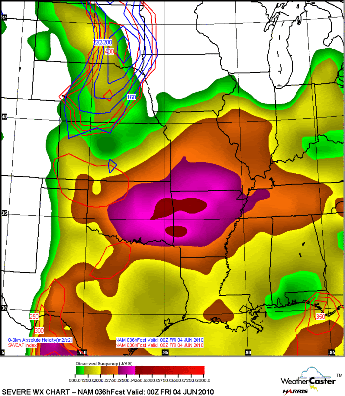
The area of strongest SRH coincides with the predicted area of storm initiation.
I also took note of Energy and Helicity at 00z as well - and models are painting a localized "3" for Energy and Helicty as well just north of the O'Neill area. Taken at face value, this would, obviously, *suggest* a possibility of a rogue tornado and maybe even one with some punch to it at onset before it gets conglomerated into a mess and moves into more stable air with eastward progression diminishing any tornado chances (if that happens at all) and increasing hail and damaging winds potential.
UCAR GFS scan at 00z breaks the cap in this general area tomorrow as well, just north of O'Neill in the area of highest severe parameters and potential.
The bottom line is, I'm not holding out for any sort of big earth shattering Bowdie show tomorrow. Instability will be strong, and, on the nose of a low level jet - at least on the onset, I'm thinking with high SRH/EHI values and GFS breaking the cap at a point of strongest instability, I think there's a chance that there will be a small window (1-2 hrs after initiation) of supercellular activity (see the Supercell Composite Index to verify this thinking) with the offside chance of a tornado IF it can remain discrete and IF other storms (which will develop) don't choke it to death first. IF it can remain discrete, tornadic chances would dramatically increase, but this is roulette here. Banking on maybe some O'Neill Magic? With that said, I'm looking for it to quickly morph into a cluster of severe thunderstorms (see 42hr GFS) which might aid into some spectacular structure and photography opportunities as it develops into a complex through the early evening, spreading mainly east, with the risk of damaging hail and strong downdrafts.
Edit: Concerns with LCL heights may limit or negate any tornado potential, but I'm still going out on this one - as a storm chaser, I just might have a field day with structure... You just..never..know. And I have a feeling I'm going to have the plains all to myself on a day like tomorrow, which makes me even more excited!
Supercellular chances appear marginal for the most part in maturity, tornado chances *appear* even less once it gets going into an organized complex. However, with lifted indices indicating strong instability on the order of -6 and modest cape around 2500 j/kg (im believing the modes as slightly stronger then what SPC is indicating) being aided by 65-68 degree dewpoints - any thunderstorm activity does have the potential to be severe with hail and high winds as the predominant modes.There is good directional shear but speed is lacking according to sfc and 850/500 crossover plots from GFS. Though I agree with SPC the predominant mode will be a messy cluster with hail threats and damaging winds in some segments when it matures quickly- I'm really liking what I'm seeing with storm relative helicity:
The area of strongest SRH coincides with the predicted area of storm initiation.
I also took note of Energy and Helicity at 00z as well - and models are painting a localized "3" for Energy and Helicty as well just north of the O'Neill area. Taken at face value, this would, obviously, *suggest* a possibility of a rogue tornado and maybe even one with some punch to it at onset before it gets conglomerated into a mess and moves into more stable air with eastward progression diminishing any tornado chances (if that happens at all) and increasing hail and damaging winds potential.
UCAR GFS scan at 00z breaks the cap in this general area tomorrow as well, just north of O'Neill in the area of highest severe parameters and potential.
The bottom line is, I'm not holding out for any sort of big earth shattering Bowdie show tomorrow. Instability will be strong, and, on the nose of a low level jet - at least on the onset, I'm thinking with high SRH/EHI values and GFS breaking the cap at a point of strongest instability, I think there's a chance that there will be a small window (1-2 hrs after initiation) of supercellular activity (see the Supercell Composite Index to verify this thinking) with the offside chance of a tornado IF it can remain discrete and IF other storms (which will develop) don't choke it to death first. IF it can remain discrete, tornadic chances would dramatically increase, but this is roulette here. Banking on maybe some O'Neill Magic? With that said, I'm looking for it to quickly morph into a cluster of severe thunderstorms (see 42hr GFS) which might aid into some spectacular structure and photography opportunities as it develops into a complex through the early evening, spreading mainly east, with the risk of damaging hail and strong downdrafts.
Edit: Concerns with LCL heights may limit or negate any tornado potential, but I'm still going out on this one - as a storm chaser, I just might have a field day with structure... You just..never..know. And I have a feeling I'm going to have the plains all to myself on a day like tomorrow, which makes me even more excited!
Last edited by a moderator:
")