3/30/2006 REPORTS: KS,NE,OK,TX

Well, I missed the two highly visible tornadoes near my hometown (DOH!) as I was engaged with a very nice looking wall cloud with very good rotation near Lindsay. After finally coming to my senses and getting on the tail-end, we saw most of the action near Pernell/Elmore on through Ada. God bless the GPS, it kept us ahead of the storm the whole day. Props to that thing.

Anywho, onward with the report. We watched the wall cloud in the Elmore City-Pernell area and heard the reports of tornadoes, but we watched this thing the whole time and did not see anything highly visible, so I bet they were rain wrapped, which I will have to check film on to check. Either way, the storm cycled down and went through a split about I-35, which really threw us off for awhile, as I found myself in between two storms and both had some decent rotation at times.

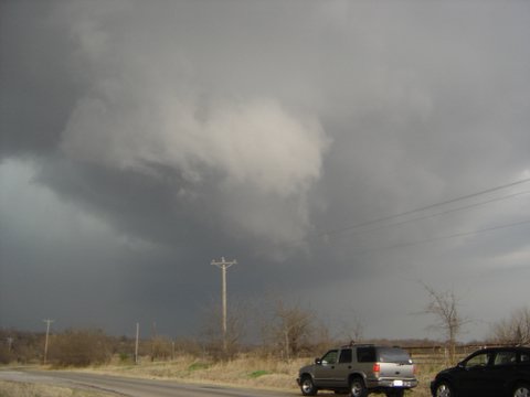
Finally, I'm pretty sure we observed a rain-wrapped tornado about 10-15 miles WSW of Ada. We experienced some ping-pong balls falling from the sky just before that, then the wall cloud completely wrapped itself in rain. We approached from the North and we began seeing a lot of leaves falling out of the air just about a 1/2 mile from the rain. We then saw a couple of trees broken in half, but I'm not sure if this was from a tornado or not, but I'm fairly sure the leaves were caused by a nader.

We later heard the reports of debris falling from the air from this same storm, so I imagine it was one of the folks who were convoying behind us (we had channells 11, 4 and 9 right behind us for about an hour and a half). Either way, it was a great storm and another great set of memories. I wish we could've saw the first two within a few miles of home, but I will not be too picky, this was the first Supercell I've seen in what seems like forever. Now time to focus on the next event...
 
Coming into Ratliff City I saw Shane Adams on the side of the road in his blue hatchback looking completely dumbfounded so as I screamed by I leaned on the car horn like a train. [/b]


(really laughing)

I never stopped in Ratliff City and I don't own a hatchback. The only person I heard honk at me was in a red SUV, and this happened south of Pernell. But the "completely dumbfounded" part I believe.
 
I left the KSBI studio today at 1:20pm. Almost immediately after leaving, I was in a torrential downpour, then started hearing the unmistakable sound of hail hitting my truck.

I pulled off I-35 in Moore at Indian Hill Road...with some nickel to quarter sized hail. No damage, thankfully.

My focus was down closer towards the Ardmore area, so I headed back south on I-35. I crossed over the Canadian River and off to my west, I saw a lowering, so got off at Goldsby. I was pulled into the Goldsby Baptist Church parking lot recording what was happening with the lowering, when Brady Brus told me that there were some tornado reports in Choctaw.

We considered having me head back up towards OKC, but then decided to keep focused on the southern storms. I got off at exit 72 near Pauls Valley when I saw the lowering, then decided to head a bit further south. I got off at exit 66 and saw the storm becoming better organized. The storm was headed straight at my location so again I headed a bit south. I'm glad I did. I was able to get some very good video from the south end of the two storms, including a very good inflow and tail cloud. At one point, the storm seemed to be struggling to produce a tornado, almost directly over I-35, but the rotation weakened on it.

I started following the storm towards Ada, but needed to meet the satellite truck back in Pauls Valley to get the video ready for the news. I was able to get some good pictures of the McAlister, OK supercell, and an anvil with nice mammatus. Those will be posted shortly, and some video captures may be posted sometime during the weekend.
 
No tornadoes today for me -- and not much of photogenic anything due to the persistant cloudcover. But a really fun chase, nonetheless, especially considering it was in my back yard. I started out by driving west a bit on I-80 and waiting at a rest stop just east of Goehner, between Lincoln and York. I got the impression that the dryline storms out west were going to be completely linear, and I noticed that convection was trying to pop from an area basically overhead to points south into Kansas. So I dropped south. Eventually, a supercell formed south of Beatrice, so I headed back east to HWY 103, then dropped south to Crete. As I was doing this, the Beatrice cell was really getting wound up, and given the fact that everything was tearing along at 50+mph, I only just barely got NE of the cell on HWY 33 before the core could catch me. This was actually pretty cool, as CGs were dropping left and right around me about once every 2 or 3 seconds -- and they were really, really close, close enough to get the 'radio hum' before the strike. I stopped about 2 east of Roca to watch the 'meso' (not too impressive looking) roll by and to get in position to try to close in on it (briefly) once I had a clear shot at the inflow area. Unfortunately, the storm started falling apart at around this point. Still, it was the only game in town at the time, so I tailed it by taking the grid roads to the north. While I was doing this, I noticed another cell forming to the south. To be honest, I didn't have a lot of hope for it, as it had plenty of crap convection surrounding it, but the original cell I was on was limping into Lincoln like a wounded deer, so I decided to "try" to get east before the core of the new storm overtook me. Drove east on Hwy 2. No luck, but at least I only caught the blinding rain and wind part of the core, not the hail part. It seemed pretty clear, though, once I got to Syracuse, that the storm I was positioning for wasn't going to make the cut. I munched out on Slim Jim's & Strawberry milk as disorganized storms marched overhead. Once it was clear the the squall was going to march in and finish the day, I decided to go and try to meet it somewhere picturesque, so I took HWY 2 back to Lincoln. Got to the outskirts of Lincoln just before the squall did, and let me tell ya -- it was one of the more visually frightening things I've ever seen. I knew I wasn't in danger, but it looked like something out of one of those Apocylpse movies. I sat in my car with my jaw dropped as I watched a massive, impenetreble fist-like curtain of rain sweeping across the horizion towards me. I mean you could really see it coming. I parked next to HWY 2, and boy was it was making the traffic on HWY 2 freak out! Once it got right on top of me, I could literally see the power of the downdraft -- the rain flying horizionally several thousand feet overhead, and then whoosh! The car rocks as the gust front hits and the visibility goes from 5 miles to 5 feet in just a couple seconds. It was all over in five minutes, but wow! I'll never get the image of that squall coming in out of my head. It's one of those things that's so surreal that you wonder if you're dreaming.

Now, I saw no tornadoes today, but I still had an awesome time. Between the wondergul squall and the challenge of getting in position (even though the storms died), I had a good chance to shake down my equipment setup and have fun doing it. Plus, the usual chase magic was following me around. For example, at the gas stop in Syracuse, the clerk who was ringing up my Slim Jims seemed really distracted... and then she suddenly got this huge smile and blurted out to me that her sister, who has had cancer for the last 3 years, just called her and told her that her cancer was in remission. Outside, the last storm had just rolled through and the sun was poking through the clouds for the first time of the day. Yeah, it was a pretty cool chase.
 
(really laughing)

I never stopped in Ratliff City and I don't own a hatchback. The only person I heard honk at me was in a red SUV, and this happened south of Pernell. But the "completely dumbfounded" part I believe.
[/b]

Bingo, that was me. Just I got the location wrong in the post. But I did notice you werent driving your white car with the back window blown. You were in some car with split antennas on top.
 
This morning after class, me and a few other meteorology students here at UNL made our way west toward York and then south on US-81. We were hoping to get to north-central KS. During our drive a few tornadic cells popped up in the Salina, Ks area. So we were hoping to get in front of it somewhere near the NE/KS border. Although I haven't heard this in any other reports, we were able to catch a quick glimpse of a funnel to the southwest of Hebron around 1pm. It happened so quickly, I was only able to get a few minutes of video of the wall cloud, but it wasn't anything out of the ordinary. Unfortunately, this particular area was weakening rather quickly, so we decided to head east toward Fairbury to get ahead of the Salina cell which was quickly heading to the northeast around 55 mph.

By the time we had gotten to around to about 6 miles south of Beatrice, we were just barely ahead of the storm. It had amazing speed. As reported by another person above, the storm began to bow out. While heading north on US-77, the storm overtook us and we were hit with 70 mph winds, heavy rain, and around quarter size hail. So after we let the heavier rains pass we headed back to Lincoln to end the day.

I believe this particular line would eventually be the one that went through the Papillion and Omaha areas causing some damage. Lessen learned today: Keep lots of distance between you and the storm when it is moving at 50+ mph.

All in all, I really enjoyed the chase today. It's been two years and the wait was well worth it. Sometimes it's just important to have some fun. Most importantly, I pray that there were no injuries today.
 
Work was a late start today which did allow me to be able to get a local chase in to start the season this year, and I was not all that dissapointed. Since I know I had to get back to work by 8 tonight, going farther south towards Omaha-Beatrice was not an option, so I took the hand I was dealt.

Stayed back for a while watching an unorganized, sloppy mess get going all around me here in NE Nebraska. When some storms began to take on severe characteristics and went tor warned, I was on the road to intercept.

Observed today was a nice gust front/shelf cloud with non-rotating lowerings and some eddies that were deceptively swirling about. Once in the beast, (moving from the northwest to south you had no choice but to get in there, plus when I was arriving coverage was increasing remarkedly), I got hit by extimated 50-55 MPH winds with higher gusts -- tumbleweeds were flying on and over my car like crazy. CGs were not very constant with these cells up here, however, there was some nice CCs intermixed.

Hitting the core was like entering a waterfall with torrential rains and possibly some pea hail, but the rain/wind combination brought visibility down to just in front of the hood of my Explorer.

I intended to chase further, but after encountering this cell, everything went to a stratiform heavy rain mess, and there was nothing more with any semblance of structure to see so I went home.

Am I dissapointed? Not at all. As a storm chaser, I chase storms, and was thrilled to start off the season with a great show of convection. No tornadoes, no severe hail, lots of lightning, strong marginally severe winds -- I wont call that a bust by any means -- I call it the season opener. Here's a toast to the rest of the season.

Got video of the core and the gust front and non rotating lowerings -- will see if anything worth showing here later. Fun day!


[[My favorite picture that I took]]

Click it to see all the pictures.

When I get my video back, I'll do some video captures for some other pictures.
 
Kenny Tapp and I left OUN around 12:45pm to target the supercell just south of Chickasha that finally had a nice presentation on radar. We proceded to head toward Lindsay, OK where we randomly met up with good friends Aaron Kennedy and Ashton Robinson (fellow grad students at OU). We watched some unorganized scud and brief funnels such as the first one pictured in my link at 2:20pm. At that time we made the incorrect decision to head northeast back toward Maysville instead of diving south toward the Duncan supercell. It was a blessing to have the KFOR simulcast on 1520 AM, as they soon informed us of the brief tornado on the ground near Purnell as we maneuvered around leisurely rural Oklahoma traffic toward Elmore City (definitely not a city either). Although too late for the brief tornadoes, we were able to witness the redevelopment of the mesocyclone directly overhead just southwest of Pauls Valley - more amazingly we could make out the cyclonic and anticyclonic couplet, just as you learn in your textbook mesoscale course. After witnessing this we tracked back northeast toward Wynnewood where we called it an afternoon as things looked fairly ragged.

mar3006c.jpg


Overall it was a fun chase, but the event definitely did not live up to the PDS hype. Early initiation, backed winds aloft and too many storms fighting for inflow definitely limited the action today - but it was nice to see supercells with some structure, lightning and heavy rain (we managed to avoid the hail). AND its only March...errr for one more day!


A couple of my best pictures of the afternoon: http://weather.ou.edu/~nwilson/chasing/mar3006/
 
I'll try to keep this report short...

I waited around OUN to see if the convection in southwestern OK would break up into discrete storms. I (with Jana Lesak, Gabe Garfield, Justin Walker, and *forgot the name,,, sorry!*) were originally planning on hitting up the storm near I40 to the west of OK, as it appeared to be becoming discrete. However, as we were leaving OUN, the cells in southwestern OK looked to be breaking up a bit, so we headed south in hopes that some insolation down there would help the cause.

The first storm we hit was northeast of Chickasha. It looked kind of outflowish, and it appeared as though the storm to its south was raining into that storm's inflow. So, we dropped south, eventually ending up two storm south in Pernell. We sat there for a bit and watched some nice RFD and wallcloud action to our west. We stayed with this storm through east of Wynnewood. Rotation was evident from time to time, but it didn't look too impressive. At some time, another cell developed to its west, near Paul's Valley. We watched this storm as we moved with it through Ada. We did stop somehwere west of Ada and watched some incredible rotation. The rotation of the rain bands and wallcloud is some of the most intense I have ever seen, and we all thought that the storm was going to produce. Well, it didn't.

We kept with the storm through Ada, where road network options became an issue. Here again, however, we did see some very nice, very wet RFD action. We ended up having to head into the forward-flank downdraft core for a bit, and we got some penny-sized hail for a while. Through the rest of the daylight time, we followed this storm through east of McAlester. Road network was a problem, as were hills and trees. We did have a time where we were north of the strong rotation and south of the larger hail and main core (in the 'bears cage' as some refer to it as), and there was at least one time where the storm possessed a very low, very large wallcloud. However, even then, the wallcloud(s) didn't look all too organized. We called off the chase northeast of McAlester.

Overall, I was slightly disappointed with the chase. We were able to get on two nice supercells, and there were a couple of times during which I really thought we'd see tornadogenesis (particularly that time when we were 10-12 miles west-southwest of Ada). However, something was obviously missing. Speaking of missing, I'm not sure how we missed the tornado near Velma, since we were watching it, but I assume it was a precip-blockage issue. I was also surprised that, despite sampling almost all parts of that supercell, the largest hail we experienced and saw was penny-size. For whatever reason, the supercells largely looked HP, with very wet, precip-filled RFDs (though they both had clean RFD occlussions once or twice).

It was good to finally chase west of McAlester. Roads were pretty bad, trees were abundant, and hills got in the way. This area wasn't HORRIBLE, and I don't think I'd avoid chasing there if there was a supercell there, but it certainly isn't what I would consider to be "good" chase territory, that's for sure! I'll probably throw some pics up tomorrow.

EDIT: I should note that, as usual, OUN was on the ball in terms of their presence on area ham radio / spotter/skywarn repeaters. There was quite a bit of play-by-play on the Cyril and OKC repeaters (also some good info on a freq that I have labeled as "Ardmore", but most be somewhere nearer Pauls Valley or Ada). Awesome job keeping everyone on the ball -- chasing and spotting is much easier when we have that good information!

My cellphone data worked intermittently, largely because I left my external antenna at home. Gr.
 
Wow...I'm beat...just returned from chasing in KS. Me and my Dobie "Sky" that is! Jeff decided to head south earlier in the day and I decided to head North (towards the low). Unfortunately we had an equipment mix up and SOMEONE ended up with my GPS. I am rotten at reading maps, well, I think only rotten at reading them when under the gun. So I tried to navigate around the storms without GPS on XM and without the DeLorme on my laptop. The tornadic supercell near Freedonia...well I missed that one...flippin' trying to get my bearings, find roads, these storms were flying! So I ended up crashing down to another storm coming up to Independence, Ks that storm had a nice cone to the ground...I have posted pics on my website but will post video tomorrow evening. http://www.twisterchasers.com/2006_storm_c...rch%2030%202006
After chasing that tornado for a good long while I turned back to another storm coming up behind it....At Buffalo, KS...things got pretty hairy...the circulation was wrapped in rain...but looked so incredibly cool...then as it trucked on NE a nice trunk came to the ground. I only have video of that one. Then I followed that storm up to Chanute then Iola and east on 54 it was getting dark but looked to me that another cone, trunk had formed and was imbedded in the core. This is on Video as well. I hope everyone stayed safe. Now I'm going to sleep and getting rest for SATURDAY!
 
We kept with the storm through Ada, where road network options became an issue. Here again, however, we did see some very nice, very wet RFD action. We ended up having to head into the forward-flank downdraft core for a bit, and we got some penny-sized hail for a while. Through the rest of the daylight time, we followed this storm through east of McAlester. Road network was a problem, as were hills and trees. We did have a time where we were north of the strong rotation and south of the larger hail and main core (in the 'bears cage' as some refer to it as), and there was at least one time where the storm possessed a very low, very large wallcloud. However, even then, the wallcloud(s) didn't look all too organized. We called off the chase northeast of McAlester.

It was good to finally chase west of McAlester. Roads were pretty bad, trees were abundant, and hills got in the way. This area wasn't HORRIBLE, and I don't think I'd avoid chasing there if there was a supercell there, but it certainly isn't what I would consider to be "good" chase territory, that's for sure! I'll probably throw some pics up tomorrow.

EDIT: I should note that, as usual, OUN was on the ball in terms of their presence on area ham radio / spotter/skywarn repeaters. There was quite a bit of play-by-play on the Cyril and OKC repeaters (also some good info on a freq that I have labeled as "Ardmore", but most be somewhere nearer Pauls Valley or Ada). Awesome job keeping everyone on the ball -- chasing and spotting is much easier when we have that good information!

My cellphone data worked intermittently, largely because I left my external antenna at home. Gr.
[/b]


me and my buddies were also on that storm. at one point we had a nice little group on the bridge over US69 just east of that ammunition plant south of McAlester. but we were watching one wall cloud, then noticed another lowering further to the west, and it looked really low, but there was a hill there. but some guy that was "with" channel 2 called it in as a tornado on the ground, which i think is ridiculous. it was too far away to tell. so maybe my first tornado, maybe not. we decided to label it as a tard-nado. we moved a little north on 69, stopped to watch both areas, and saw a few different funnels that were very interesting. one was like a rope funnel, with broken condensation leading outward and down on the far east side of the east wall cloud. it was spinning a little bit, then disappeared in about 20 seconds. very cool to see. not a bad chase, considering it was visual.
 
Sorry I didnt get your message ya left for me Todd until later this evening. My Wifi only works if Im basically right on top of a solid siganl which I left in order to watch the storms that were moving towards Mountain Park NW of Lawton. Btw there is a wifi hotspot at the cracker barrell at the hotel behind it in Lawton.
Anyways I watched the storms to the NW strengthen along with a group of cows and then decided to follwo the cell as it kinda went parallel to I-44 North of Lawton. The storm began to exhibit signs of a wall cloud and some weak rotation and produce some half-dollar size hail. I took a few picks and followed the cell on into Chickasha. I decided to let this cell go on towards the metro as I did not run into all the moms crowding the highways to pick up kids from as well as the chaser hoards and I jumped over towards hwy 81 and went south to catch the cell that would produce possibly a couple weak tornadoes North of Velma. I caught this cell and followed it towards Elmore City adn sat atop a hill on I think hwy 29 and took some timelapse of the wall cloud passing very near as sirens sounded in the town.
I saw what I thought were a couple brief funnels with very good rotation in and around them and what at times was a rather large wall cloud. After tonights inspection on the timelapse I do believe one of these funnels touched the ground but oh so briefly. On the time lapse you can cleary see debris fly up towards the funnel off the ground and then dissapear. It was very very brief but now I do believe this was indeed the weakest or tornadoes but the time lapse was pretty neat. I followed this cell as it weakend towards Ada and waited as it died for the backbuilt brother to arrive that also began to have some good rotation. I decided to leave this cell at Ada however and head home even tho there was reports of debris falling from the sky such as leaves.
I headed South having to manuever sround the Indian Nation turnpike due to construction but caught a small LPis looking cell near Sulphur. I could also see the nice updraft and the anvils of storms to the SW along the Red River and decided to head that way on the way home to catch a few lightning pics.
I LOVE it when you can kinda ladder step your way South and catch multiple storms! Sometime ya wish ya didnt leave the northern storm but other times it can make ya look like a genious. :p.
For a March chase this wasnt bad at all and I think this may be my first tornado in March.
Ill post pics and vidcaps and perhaps a brief timelapse on my website at http://www.texhomastormchasers.com
Memorbale things about this chase were.
1. Happy Cows arent jsut in California
2. Amazing rotation at times
3. Not alot of really large hail reports. Golfballs largest maybe?
4. Very early chase hours
5. The quickest tornado touchdown I have ever seen
6. Amazed how people will block overpasses when there is only pea size hail
7. The Indian Nation turnpike under construction and a 13 miles detour
8. The newly "fixed" road on I-44 near Elgin drains VERY pourly. Hydroplaning there was horrible. Had to do about 45 mph to keep her on the road.
9. Road networks once out of Ada to the East are not very good along with hills and trees galore.
10. My forecast was pretty good. I figured we would have a better tornado producer South of I-40 but oh well. I was unconvinced it had even produced earlier but after viewing video I can "kinda" count this as a First tornado of the year tornado but I still only really count the ones you can look at and say " Oh my god! Look at that tornado!" ;-)

I also saw what was actually a very humbling scene in Chickasha. They had a funeral procession for a fallen firefighter who I believe was killed in duty last week or so battling grass fires. There were TONS of firetrucks, police, & utility trucks all driving beneath two extended ladders from two firetrucks that created an arch. When this occured it also completely stopped raining at the exact time. It was as if heaven actually was opening up for someone.
 
Back
Top