Ed Grubb and I departed Oklahoma City the morning of with an initial target of Great Bend, Kansas. Upon our arrival, low clouds and cool temps greeted us. After a delayed lunch stop (Wendy's took the fast out of fast food) and fuel, we quickly decided we were going to dive southwest on US-56 and aim for the Dodge City area. Moments after making that turn, I flipped us north on a dirt road to connect back with K-96 west of Great Bend and said I was going to "drive west til we see the sun".
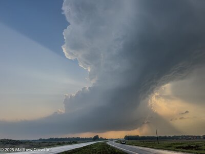
So west we went through Rush Center, Ness City, and as we approached Dighton, SUN! We made it. A surface analysis showed an arcing dryline, curving from west-east to almost north-south with a few blips starting to pop. With Scott City being a bigger town, we opted to hop over there for a final fill-up. About this time, our blips were becoming full-fledged storm, with the western storm becoming tornadic. Our focus was the eastern storm as it was not going to be sucking in the air of a sibling like the western storm.

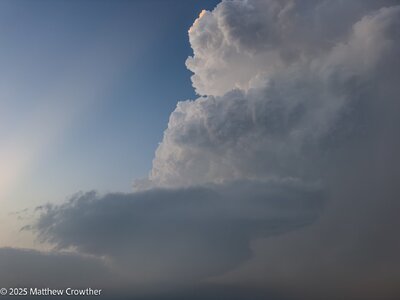
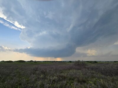
We drifted a few miles north to maintain a view of the base... inflow was massive and while the view of the updraft wasn't great due to clouds, we would occasionally see a massive barber pole in the breaks. The storm was far enough west where we didn't have the greatest contrast, it quickly became evident 'something' was happening. I was relaying info via NWS chat to Dodge, giving them a textual play-by-play as several funnels would tease their way down, when finally, the first tornado, a briefy, dropped shortly after 5:30pm north of Scott City.

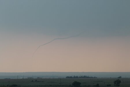
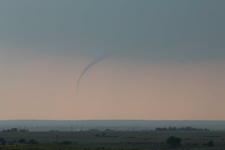
This tornado lifted, and we continued north to stay with the cell. The area where the initial tornado formed underwent a new cycle (you could see the ragged wall cloud give way to a much smoother look before a new round of fingers began to develop. Shortly thereafter, we saw multiple funnels, before seeing a couple start to tickle the ground.

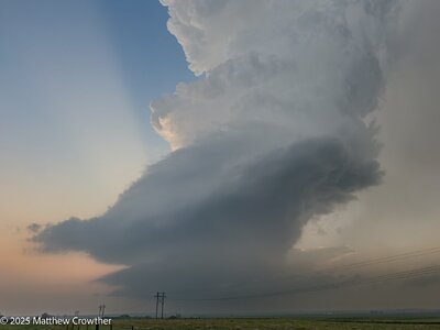
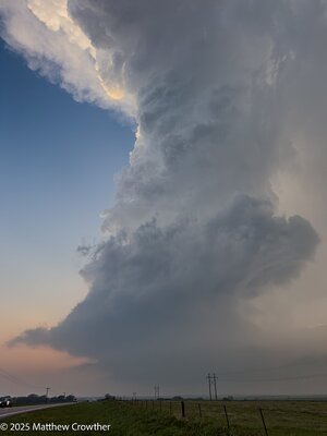
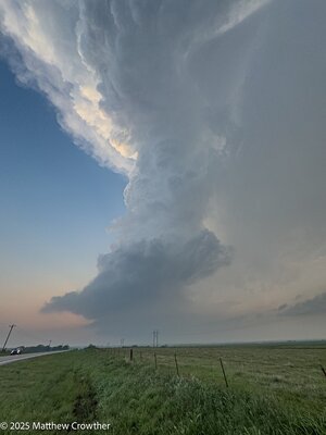
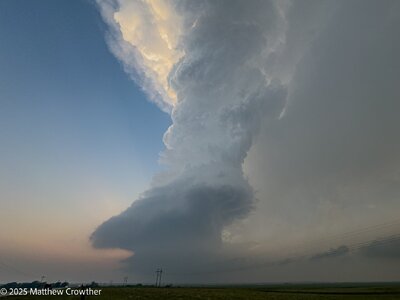
These funnels played around with each other for a moment or two before merging (so it appears from our vantage point) and combining into what would become the (assumed) long-track wedge.

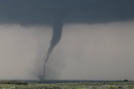
It grew to a wedge very quickly, a wide tornado with a very low base. We basically had the easiest viewing of this along US-83 northbound, stopping occasionally to collect imagery as we kept pace with it. US-83 has a short jog northeast north of K-4 that gave us a little extra time as it was almost parallel to the tornado's path. Occasionally, a satellite would rotate into view before being absorbed by the main tornado.


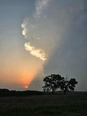
We continued north of Scott Lake State Park, stopping at a Historical Marker with a good view over looking the valley. By this time, our wedge was losing contrast, and with the hail core to our north and the tornado approaching US-83 into an area with NO roads, we noticed a cell immediately to its south that also had a look. We decided, "hey, we got all we can out of this, lets give the south cell a shot so we can see other tornadoes".
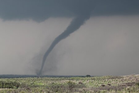
So we left it, yes, we left a WEDGE IN PROGRESS... we dropped south, virtually into the same place we saw the tornadoes before. And boom, new tornadoes.

After a couple briefies, a larger tornado developed south of the State Park. I noticed on the map that K-95 spurred off US-83 at the northeast dogleg and having never been on the road, I thought, "hey, there's a road that would put us closer for a time!" And I was right! Buuuuuuuttt...
It was all pretty much in a canyon, no view looking west. None, zero, zilch... we spent about 10 minutes hauling around up into the park, eventually turning back east and connecting us with US-83. As we finally got back to US-83 and had a view back to the west, we watched the tornado end. We have no imagery of this, but assume the tornado we saw starting before we dropped into the canyon was the tornado we saw end as we got back to US-83.
I was annoyed, bad choice... cost us views of that tornado. We continued north on US-83, letting the business end pass us with no further tornadoes. From where K-95 rejoins US-83, we had a 30-mile drive north to catch I-70 at Oakley. Both storms were over no-man's-land east of US-83 around the Monument Rocks area. With no legit east-west options, it was going to be I-70. The plan was to get up there and cut east, possibly skirting the south side of the southern cell to get east, then north to get back in front of the storms.
We got to Oakley, and radar indicated the the northern cell still had a tornado ongoing (what we could assume to be the wedge we were on 45 minutes prior). We figured that cell was going to cross I-70 at Grinnell, and with only about 10 miles separating us from the tornado, we figured we may have a shot. We were concerned the core of the southern cell may cut us off, but if we could "shoot the gap", we could get in front of the circulation.
As we approached Grinnell, we were hook-slicing from the west, definitely not my favorite move, particularly since we had the core of the southern cell inhibiting any real cleaner view of the hook. As we approached mile-marker 83, two miles from the Grinnell exit, we slowed to an eastbound crawl, buried in heavy rain and some small hail. We continued slowly, many cars on the shoulders waiting out the storm. We kept moving. Ed in the passenger seat calling out the views as I navigated us east.
(NOTE: we were now re-intercepting what we assumed to be the same tornado we had abandoned 45-minutes earlier and saw other tornadoes on the other cell before returning)
Passing Mile Marker 84, things began to change... still no real view of what was going on, but the wind directions indicated we were still okay. Suddenly, Ed observed atomized rain in the field to our south, and the air began to fill with light field debris, thickening up very quickly from north to south. We were nearly stopped, basically a 1mph coast. The debris field was thickening, and we stopped. Suddenly the precip curtains parted and there it was, 150 yards in front of us...
Seconds later, a semi we passed a few miles back flew by us, absolutely oblivious to the now VERY apparent tornado on the round. He drove straight in, and we watched him hit the tornado, flip on his side, and get THROWN off the interstate into the field on the south side of the interstate. As the tornado cleared the interstate, we raced up to where the tornado crossed, seeing another semi half-off the interstate, and the one we watched get thrown sitting in the field, surrounded by a handful of vehicles scattered about.
Ed and I pulled off on the shoulder, me immediately calling 9-1-1 to let officials know what had happened and that Grinnell was badly hit (we could see the west side of town in shambles as the tornado was roping out) and geared up, me racing down to the truck driver who was somehow alive, buckled into his seat which was completely exposed as the cab around him had been shredded and was virtually non-existent. I confirmed with him that he was alive, albeit bloodied and likely concussed. I wasn't able to get to him as there was nothing I could safely climb up. By this point, other people began to show up. I handed him a towel to wipe himself off, telling him to stay put as I focused my attention to the nearest vehicle to the semi. I ran up to it, stopping before I peaked in to take a breath, figuring I was about to see something awful. When I looked in, the car was empty.
The driver of the semi started yelling "those are my cars, those are my cars". The covered trailer he was towing had six Ferraris, all of which were ejected from the trailer and were the vehicles we saw scattered about. The sigh of relief I had was so massive. We returned full attention to the driver, who was slowly getting himself oriented. Others were on the scene and one being a fire fighter, took over the scene. We could hear sirens filling the surrounding air, both at our location and in town.
We finished what we could do before returning to our vehicle, and as more crews arrived, we moved on to get ourselves out of the way. Meanwhile, we saw a fleet of emergency vehicles heading into town, so we figured we were good to move on at this point.

The rope out was beautiful from the images I saw, but given we were neck deep in assisting, neither of us ever got any shots. I remember seeing it in passing glances as I was moving around, at one point tripping and face-planting into the mud over what was left of a fence. It was a sobering scene, and one filled with huge angst as we got our first view down the embankment at the multitude of cars. I remember thinking, "oh my God, everyone's dead". It was such a massive relief to know all the vehicles were empty. The driver was injured, but alive, and I don't know what came about after we left. But I was happy we were there to at least get things rolling.
We called the chase from this point, heading east on I-70 toward Salina as cells to our south began to die off. Lots of discussion of the event, between the highs of the incredible tornadoes, to the experience there on the interstate. All-in-all, a chase neither of us will ever forget, both for the good and bad.

It only took us 18 years to finally get a shot of us together in front of a tornado... May 18, 2025 Scott County, Kansas