Ben Holcomb
EF5
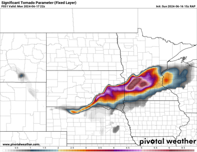
The SPC is not seemingly very bullish on tomorrow, but the 15z RAP from today is showing mid 70 degree dewpoints across southern Minnesota and Eastern South Dakota tomorrow afternoon. RAP is showing some overlap of the warm sector with the jet overhead, especially in Southern MN and absolutely skyrocketing the STP values in West Central and Southwest Minnesota and Eastern SD.

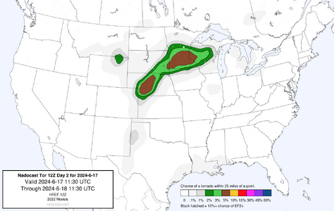
Nadocast has also been hot, showing MN and Western Nebraska areas. I'm not a fan of adding it, but it sure nailed yesterday and Silverton day and has been consistent on other days.

I got all the way back to Norman about 1 last night and thinking of making another trek northbound starting tonight to get into position. Could be a big day tomorrow. I don't want to miss that inevitable shelf after driving all those hours.
**EDIT**
Wanted to add that tomorrow has a 986mb low, deepening as we continue throughout the day. I believe June 17, 2010 was 988mb low. I swore I'd never miss another sub990mb low this late in June again.

Nadocast has also been hot, showing MN and Western Nebraska areas. I'm not a fan of adding it, but it sure nailed yesterday and Silverton day and has been consistent on other days.

I got all the way back to Norman about 1 last night and thinking of making another trek northbound starting tonight to get into position. Could be a big day tomorrow. I don't want to miss that inevitable shelf after driving all those hours.
**EDIT**
Wanted to add that tomorrow has a 986mb low, deepening as we continue throughout the day. I believe June 17, 2010 was 988mb low. I swore I'd never miss another sub990mb low this late in June again.
Last edited:
