2024-04-26 EVENT: IA/NE/KS/MO/OK

Joined
Oct 10, 2004
Messages
1,433
Location
Madison, WI
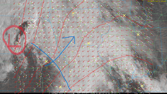
Haven't seen a discussion thread for Friday yet, with most Plains chasers understandably more interested in Thursday and Saturday. However, with Thursday's system progressing to the northeast and taking on a nice negative tilt over the Siouxland region, a fairly obvious (IMO) triple point target appears to be shaping up somewhere along a West Point, NE to Atlantic or Red Oak, IA line. Could be a cold-core type setup right on the low. The challenging thing at this point is that the Missouri River is right smack in the middle of this target area.
 
Looks to still be on track with Andy's positioning, with the best mix of shear and instability just south into Missouri. CAMs have cells going up near the river at 2100z, so I'd imagine I'd start on the East side and follow them from there. What's the terrain like for chasing up in northern Missouri into Iowa?
 
Looks to still be on track with Andy's positioning, with the best mix of shear and instability just south into Missouri. CAMs have cells going up near the river at 2100z, so I'd imagine I'd start on the East side and follow them from there. What's the terrain like for chasing up in northern Missouri into Iowa?

Southwestern part is not the best terrain in Iowa (that's up near the Highway 20 corridor around Fort Dodge/Sac City/Gilmore City, which fortunately seems to be a bit of a tornado hot spot as it's nearly as wide open and flat as the Plains); a bit hilly but certainly better than the Ozarks or most of Wisconsin.

Far northern Missouri is similar based on what I've looked at on Google Street View.
 
The shear profiles in northwest MO/southwest IA have improved even more in the latest model runs, which coincide with the strongest instability and longest duration on the warm nose. If convection can hold out until 21z as Mark notes and the latest HRRR runs indicate, I might actually be able to drive out there in time!

Dan might be right about the much better chaseability of the storms on the northern part of the low. I would just be worried if they lose steam too quickly.
 
Wouldn't be surprised to see this end up as an Eastern Nebraska play. Catch the cells an hour or two before the Missouri River region.

(Usually a bias towards slowing down a bit on the models and ending up a bit west -- although I'd take a speed up if it got us past the river... models currently have annoying placement with this one)
 
Of note is that the HRRR, HREF and ECMWF all ignite discrete convection across SW IA and N MO after 21z. The current run of models signal this being a longer lasting discrete mode here as opposed to EC NE. The 06z/25 ECMWF indicates the same pattern based on 3hr QPF outputs and the HREF even has a discrete cell firing further south into NC MO, possible associated with the apex of the upper level jet core that noses north of I-70 by 00z/SAT. This is something to watch as other parameters are otherwise favorable in the open warm sector here and there is a notable uptick in the LLJ (as to be expected) by 0z.
 
Of note is that the HRRR, HREF and ECMWF all ignite discrete convection across SW IA and N MO after 21z. The current run of models signal this being a longer lasting discrete mode here as opposed to EC NE. The 06z/25 ECMWF indicates the same pattern based on 3hr QPF outputs and the HREF even has a discrete cell firing further south into NC MO, possible associated with the apex of the upper level jet core that noses north of I-70 by 00z/SAT. This is something to watch as other parameters are otherwise favorable in the open warm sector here and there is a notable uptick in the LLJ (as to be expected) by 0z.
Latest runs seem to have backed things up west a bit. Now more of a line crossing into far SW Iowa around 0z. (latest NamNST and HRRR) I'm going to be ready to be in the Lincoln area by 21z. Today's setup ended up being a bit further west than expected as well.

Do think tail end down into far E KS into Missouri could be an interesting play, but favor terrain along I-80.
 
I'm not as enthusiastic about today at first look. For the northern target near the surface low, some sub-60F dewpoints are upstream. Shear and lapse rates are shown weakening throughout the afternoon due to the upper support being mainly south and east. The southern target depicted by some of the CAMS (Kansas City and south) has better upper support, but lapse rates again are weakening and this activity is shown as not having great separation from the mess of precip/clouds to its east. The sun is only just now coming out here in Salina, I would have liked to see that clearing line a little farther east by now. All things considered, I think the vorticity-rich surface low target looks better, so that is where I am headed - for now.
 
Last edited:
It is still early but we'll really need to get that diurnal heating going in SW IA and NW MO by this afternoon. Models do want to indicate the low pulling the surface WF north of the MO/IA border by this afternoon, although ongoing convection may suppress that further south than models were hinting at yesterday. I'd still watch for initiation proximal to KC associated with the best upper-level energy as the HREF and about 50% of the models indicated that, whereas the other 50% keep the show in IA between the MO border and I-80. There will be plenty of shear to work with and morning precipitation will help with ambient LCLs, so the northern target just needs ample time to destabilize this afternoon. Initial tornadic modes will be maximized with discrete cells early on. Some CAMs indicate a transition to a QLCS mode but that seems commensurate with Skew-T/Log-P forecasts across central IA (look at orientation relative to the boundary and direction above the lowest 3 km), so the best tornado potential may be in the open warm sector before storms reach the true warm front. 12z/26 NAM is showing some CINH southeast of the main surface low, but holy hail at those UA profiles and gigantic hydrolapses! The early afternoon convection in NE will be damn near cold core with the H5 temps pushing AOB -18C.


1714144640600.png
 
In Topeka this morning with a focus zone primarily on E/SE Kansas along and west of the HW-69 corridor. Favoring deeper moisture return by mid/late afternoon into the early evening along a modulated dryline with quick CI that will move northeast at a rapid pace. Ample/acceptable 500-850mb veering, forecast SB CAPE’s around the 3000 J/kg, Theta-e rich moisture tongue and some hint for locally backed surface winds along/S of HW 54 into MO has my attention. Suspect at least one or two discrete supercells can/will get going in that environment late this afternoon with further development towards NE OK into the early evening. Terrain and road networks are always a challenge in that geography, but favor a region from Fort Scott to Parsons, Kansas and points eastward for a discrete supercell or two. I’m also factoring in positioning for Saturday in SC KS or OK and how my energies will be by later this evening post chase [i.e. need for hotel/rest]. Shall see what transpires.
 
I would start in the KCMO area, not to chase, but for sit-down lunch and 12Z data. Interstates depart KCMO in multiple directions. North and West won't have much traffic. I-35 in Overland Park is kind of like the casinos in MO - a gamble; but, I don't think it'll be that direction.

Models have the boundary intersection lifting into OMA Council Bluffs. Again not to chase in town, but it'd be a starting point. Depending on how stubborn the boundary is, set-up could be farther south. Maybe St. Joe to Nebraska City?

By afternoon I want to be north, with the ability to adjust south, per usual chase SOP. Storm motions usually make it easier to adjust south vs adjust to the north. So KCMO is only through lunch. Maybe then St. Joe or even Nebraska City. That's close enough if one had to get to OMA. Yet it gives flexibility to go back south.

CAPE will return. Winds turn with height adequately. Initiation should be late afternoon and probably before 00Z. 700 mb isn't as warm. Nothing squirrelly in the hodograph below 300 mb. Just follow that boundary intersection at the surface.
 
Departed Salina this morning and am on the road. Targeting Vinita, OK for initial target. Not sold on northern target, and southern target is closer to home and sets me up nicely for tomorrow. Airmass recovery is already underway in se KS and central OK with rich moisture quickly surging north behind the morning MCS. Plentiful insolation already occurring so 2-3k CAPE seems reasonable. Model data has trended with a slower weakening of the deep-layer wind fields, with forecast hodographs on 12z models looking quite favorable for all hazards. I see SPC just upgraded eastern OK.
 
Hanging in western Iowa for now. Still worried about how far NE the juice will get, but the HRRR seems to think we'll get it done in the 22z-0z time frame. We shall see.
 
18Z OUN sounding shows uncapped, extremely unstable atmosphere ahead of dry line, and an outflow boundary from earlier convection roughly just east of Tulsa, moving E-W. Given the lack of capping, and that clearing will proceed W-E across the area, I am thinking to head down I-44 towards OKC as a target. Haven't decided yet--being in the Tulsa area means most of my potential targets are within a 50mi radius. "It's a blessing...and a curse."
 
Back
Top