• A friendly and periodic reminder of the rules we use for fostering high SNR and quality conversation and interaction at Stormtrack: Forum rules

    P.S. - Nothing specific happened to prompt this message! No one is in trouble, there are no flame wars in effect, nor any inappropriate conversation ongoing. This is being posted sitewide as a casual refresher.

2023-06-01 EVENT: TX/NM/OK

gdlewen

EF2
Joined
May 5, 2019
Messages
195
Location
Owasso, OK
Although I have an afternoon appointment and cannot make it into the target area today, I am hoping to hear what others have to say about the potential for severe weather on the periphery of the cold-pool/outflow boundary in W Texas today. If not for that commitment I would be on my way right now. Is that a good call?
 
There is a lot of rain-cooled (stabilized) air looming around. Raining here in LBB right now. Might be a sweet spot later, but if storms fire all at once like yesterday, it's not a good chase day. I'd look at the next SPC outlook to see what has changed.
 
Satellite shows some clearing in the Seminole/Andrews TX area, with temps warming into the low 70s and dewpoints in the low 60s. The OFB is roughly between LBB and Denver City. The 15Z HRRR run shows moisture pooling along the OFB roughly along the latitude of Denver City at 21Z, and depicts a nice right-moving discrete supercell between 22Z and 00Z around the Brownfield / Lamesa area. NAM 3KM (earlier run - 12Z) shows the OFB at about the same latitude, but has the moisture pooling further east, say around Post/Snyder. It depicts a large storm developing in the area, possibly not as discrete as shown on the HRRR. NAM3KM also shows a discrete storm near Denver City, but it does not last long. From what I can tell, neither model shows the OFB moving all that much from its current position, although SPC mentioned some drift to the north.

Overall, I'm a bit more hopeful than I was a few hours ago, and will likely target somewhere around Denver City / Adair / Seminole, subject to adjustment based on surface obs. About to check the 16:30Z SPC outlook now.
 
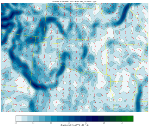
My initial argument was based on the 13Z SPC Day One Convective Outlook. But also the 12Z RAP forecast for 21Z shows a pronounced dry line bulge near Midland, and the remnant outflow boundary was prominent in the gradient of virtual potential temperature plot. Looking at the clock--the update should be any minute now...

1685637109087.png
 
There is a lot of rain-cooled (stabilized) air looming around. Raining here in LBB right now. Might be a sweet spot later, but if storms fire all at once like yesterday, it's not a good chase day. I'd look at the next SPC outlook to see what has changed.

Based on the 1630Z update, and considering I would be reading it somewhere just W of Wichita Falls if I were out, I would not change my plans. Obviously I would be counting heavily on storms not firing all at once, as you say, but--well--we'll see. Obviously at least you and @JamesCaruso will be out so I wish you all great success.
 
I know this isn’t a Reports thread (I will post all my reports at the end of my trip), but just to close the loop, we drove south toward Denver City and the OFB was clearly delineated by Cu; satellite showed it roughly on the latitude of Seminole. We went east to an area of more agitated Cu near Lamesa (after also noting significant mixing/drying closer to the NM border) and intercepted the first severe storm as it moved east toward Gail (going through some high winds and skirting the edge of the hail core as we approached from the west) and stayed with it southeast to Colorado City before it died. It had some good visuals at times and we saw a gustnado and a *possible* landspout. I enjoyed the day and it was better than I thought it would be when I woke up in the morning, but not as good as I had hoped when it was still a Day 3 and Day 2 forecast…
 
I know this isn’t a Reports thread, but just to close the loop, we drove south toward Denver City and the OFB was clearly delineated by Cu as satellite showed it roughly on the latitude of Seminole. We went east to an area of more agitated Cu near Lamesa (and also noted significant mixing/drying closer to the NM border) and intercepted the first severe storm as it moved east toward Gail (going through some high winds and skirting the edge of the hail core as we approached from the west) and stayed with it southeast to Colorado City before it died. It had some good visuals at times and we saw a gustnado and a *possible* landspout. I enjoyed the day and it was better than I thought it would be when I woke up in the morning, but not as good as I had hoped when it was still a Day 3 and Day 2 forecast…

I agree it was not as good a day as I'd hoped, but I'm glad you caught that cell. I hope you will post pictures--since I could not be there it will be interesting to correlate what I could see in the radar view with what you saw from their ground.

Bottom line: Great! that you were there.

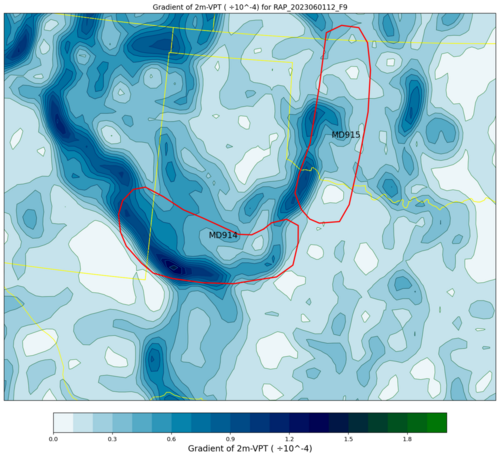
Anyway--to recap, there were two MCD issued for the area delineated by the 12Z RAP 21Z (F09) forecast for "gradVPT". And a third (not shown) along the western edge of the gradient in NE New Mexico.

RAP_20230601_12Z_F9_Gradient of 2m-VPT.png
 
Back
Top