• A friendly and periodic reminder of the rules we use for fostering high SNR and quality conversation and interaction at Stormtrack: Forum rules

    P.S. - Nothing specific happened to prompt this message! No one is in trouble, there are no flame wars in effect, nor any inappropriate conversation ongoing. This is being posted sitewide as a casual refresher.

2024-03-14 EVENT: TX/OK/AR/MO/IL

Randy Jennings

Supporter
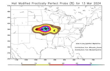
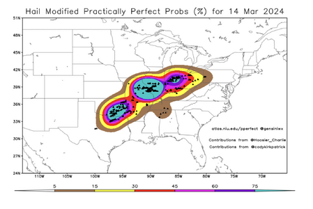
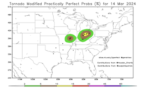
As a southern plains based chaser, today has been on my radar for almost a week now, as SPC has had an area for almost a week now and they even started tweeting about today's (Thursday's) event last weekend. I've tried not to get too excited as models have kept the upper level low way out west from the start, and now that we are to the morning of the chase, that is still the case. But with a low west of I-35 in northern OK, a front, and a dryline, it seems like we will have enough lift to get the job done.

Moisture looks good enough to get the job done with models showing warm sector Td in the mid-60's to lower 70's in TX and the mid 60's in most of the rest of the area. The observed morning soundings already show surface Td of 64 at OUN and 68 at FWD.

Instability wise the morning observed soundings already show 2400-2700 CAPE at OUN and 2600-3400 CAPE at FWD. Models show CAPE reaching close to 4500 in TX and close to 4000 in a small section of central OK by mid-afternoon. Cap is already pretty small at OUN (CIN of -48) and FWD (CIN -75) on morning observed sounding. With temps forecast to be above 80 in TX and close to it in OK, I don't see capping being an issue by afternoon.

The best sheer appears to be OK just in front of the front. The dry line doesn't look like it is going to move very far east today.

So today is a chase day for me, but the target choice is agonizing. Do I leave work in DFW really early and go north up I-35 and park myself somewhere between the Red River and OKC for storms to begin around lunch time and hope to catch a tor before the storms head into the trees and Ouachita Mountains (not to mention it is early and temps aren't that warm yet), or do a stay at work longer and stay closer to DFW and hope for some structure shots and large hail, or do I split the difference and head up US 75 to US 83 and hope to catch a storm that headed towards Paris, TX in the afternoon (and hope that I don't have hail to my southwest at home and a tor to my north in eastern OK)? I guess I will give it a little more time before I make the decision. If it wasn't for the trees and mountains in eastern OK, that would be my target, although there is a chance that area lines out into a MCS fairly quickly because of the flow along the front).
 
11am: For the Midwest component of this event, the obvious target is the outflow boundary that is just now beginning to stall out in southern MO/IL. I'm also seeing what appears to be a secondary boundary farther north right outside of home in New Baden (east of STL) baking in the sun, earlier it had some weak towering cumulus along it. How far the primary boundary can lift back to the north before storm time is the primary unknown. It should be favorably oriented for storms to latch on with slight deviant motion to the E/ESE from the WSW upper level flow. Deep-layer shear looks great with 50-70kts WSW at 500mb. The main jet streak will be departing during the afternoon, but flow remains strong. Ambient low levels are veered, but the OFB should counter that. Models hint at storms initiating and maturing west of the Mississippi River, but that area is largely unchaseable with trees, hills and few good roads. I will be waiting on the IL side of the river where the road network and terrain is much better. I'm also watching for any new leading storms to fire east of the river farther into Illinois. All should have decent tornado potential in the vicinity of the outflow boundary. Now it's just a matter of watching visible satellite and surface obs to see where the main OFB ends up in a few hours.
 
or do I split the difference and head up US 75 to US 83 and hope to catch a storm that headed towards Paris, TX in the afternoon (and hope that I don't have hail to my southwest at home and a tor to my north in eastern OK)?

I have not done any analysis for this event so this is not a technical response, but in terms of chase strategy in my experience splitting the difference never works out very well. I think it’s always best to commit one way or the other!
 
Outflow boundary is on the move slowly and knocking on the door of the St. Louis metro area. Cumulus field near Festus and east into Illinois could be the area to watch. Concerning if the boundary keeps moving and storms hold off much longer.
 
Is there also some outflow from the storms off to the SE which is kicking off the stuff near St Louis?
 
Main OFB is just south of STL, storms there will have greatest tornado potential as they head east. Storm coming into the western metro now has lower tornado threat due to veered/weaker surface winds, but has a classic look on radar. Would not be surprised if it ends of producing, large hail of course is pretty certain with it. Could be a major hail event coming right through the city.
 
Main OFB is just south of STL, storms there will have greatest tornado potential as they head east. Storm coming into the western metro now has lower tornado threat due to veered/weaker surface winds, but has a classic look on radar. Would not be surprised if it ends of producing, large hail of course is pretty certain with it. Could be a major hail event coming right through the city.
I have a devil of a time seeing boundaries in data (very frustrating for me personally), but in this 21Z analysis I see three major boundaries, with the boundary south of STL being a comparatively minor (not including the cold front, of course, which is draped across OK-MO-IL-IN.) Several smaller ones not highlighted.

MFC_METAR_20240314_2100.jpg
 
Looking at the SPC storm reports pages, I see there were more than 100 reports of hail 2 inches or larger spread from Texas to Ohio and including every state in between. I don't know if this is a record, but I personally don't recall seeing that many reports of hail that large in one day in the past. And over a very widespread area.

 
John,

Here are the "perfect prog" hail verifications for Wednesday night (Alma Tornado, Rossville Tornado) and for the Texas to Ohio event Thursday.

I've also attached the tornado perfect prog for Thursday. Of course, the IN-OH should be hatched, but this site doesn't add the hatching.
 

Attachments

  • Screenshot 2024-03-16 at 12.39.40 PM.png
    Screenshot 2024-03-16 at 12.39.40 PM.png
    455.1 KB · Views: 5
  • Screenshot 2024-03-16 at 12.39.51 PM.png
    Screenshot 2024-03-16 at 12.39.51 PM.png
    503.5 KB · Views: 6
  • Screenshot 2024-03-16 at 12.41.14 PM.png
    Screenshot 2024-03-16 at 12.41.14 PM.png
    442.4 KB · Views: 5
This chase was pretty uneventful for me, so instead of posting a rather boring post on the reports thread for 2024-03-14, I will post here because to me the more interesting thing is how so many didn't forecast this event as well as we should (myself included). Please excuse me for focusing on the southern part of this storm, as the northern part of the storm was way too far for a day chase from DFW so I really didn't look at that area before or after.

As we left the Plano TX area around lunch time and headed to just outside of Ardmore OK, I told my chase partner that I had seen this movie before, and we where not going to see a tornado in OK this day, the big tornado show would be well to our NE, and meanwhile back at home in Collin County TX we would get gorilla hail and even a tornado warning, but no tornado. I was right, except a few miles from my home in Collin County there was a bird fart EF0 tornado (although it really did mess up a car bad). To me, this is lesson #1 here - I knew what was likely to happen - but it is very hard to skip a SPC 10% hatched TOR for an area that is in a 2% to 5%. We need to trust ourselves more. (The pessimist in me says if I had stayed close to home the cap would have won out).

We ended up travelling from Ardmore to Madill and where in the polygon when a tornado warning was issued for Madill at 5:51 PM. Rain made it hard to see anything, but we really didn't think there was anything to see, and that was correct - that cell never produced a tornado. We chased it to the northeast and did see a brief wall cloud later, but nothing exciting. We gave up on it, despite still being warned, as it was headed into bad chase territory and tried another cell to the southwest. No luck on it and we headed home.

So what went wrong? The only 2 tornados in OK was a early one at 1:45 PM CDT in McIntosh Co OK along I-40 and a late one at 11 PM CDT near Broken Bow. To me it seemed like the storms went linear along the front quick and one cell was raining into the next. As I noted in my original Event threads post "there is a chance that area lines out into a MCS fairly quickly because of the flow along the front". Models seemed to show fairly discrete cells, but that wasn't what happened.

I think the 7:57 AM CDT SPC D1 Outlook by Edwards/Dean nailed it: "The duration of the threat, as well as the potential for tornadoes once hodographs enlarge greatly in late afternoon/evening, will depend on the number of relatively discrete supercells remaining. That is uncertain, given a substantial component of deep-layer flow parallel to the likely corridor of greatest forcing, which suggest a transition to messier convective modes." I think that is lesson #2, flow matters.
 
Back
Top