• A friendly and periodic reminder of the rules we use for fostering high SNR and quality conversation and interaction at Stormtrack: Forum rules

    P.S. - Nothing specific happened to prompt this message! No one is in trouble, there are no flame wars in effect, nor any inappropriate conversation ongoing. This is being posted sitewide as a casual refresher.

2023-03-31 EVENT: AR/IA/IL/IN/MO/MS/TN

Michael Towers

Supporter
Joined
Jun 28, 2007
Messages
359
Location
Machesney Park, IL
The preliminary survey from NWS Davenport lists the two wedge tornadoes near Keota as a single tornado of maximum EF-4 strength (Tornado #7 – Keota, IA).


I think the close proximity between the location where the initial tornado dissipated and where the second tornado began has them mistaking the paths as a single path and hence the same tornado. The initial tornado dissipated near Hwy. 92 and likely no later than 4:15 p.m. yet they have it extending many more miles and ending at 4:37 p.m., the track and duration very similar to that of the second tornado. I contacted them and in addition to informing them about what I observed I linked both my video and the full video by @Andy Wehrle for them to review. I hope this provides evidence and clarity that what they have as one tornado was indeed two tornadoes with the first being a maximum EF-3 and the second a maximum EF-4. Anyone else who witnessed the event and wishes to provide them with further information can contact them at:

[email protected]

[email protected]
 
Last edited:
The preliminary survey from NWS Davenport lists the two wedge tornadoes near Keota as a single tornado of maximum EF-4 strength (Tornado #7 – Keota, IA).


I think the close proximity between the location where the initial tornado dissipated and where the second tornado began has them mistaking the paths as a single path and hence the same tornado. The initial tornado dissipated near Hwy. 92 and likely no later than 4:15 p.m. yet they have it extending many more miles and ending at 4:37 p.m., the track and duration very similar to that of the second tornado. I contacted them and in addition to informing them about what I observed I linked both my video and the full video by @Andy Wehrle for them to review. I hope this provides evidence and clarity that what they have as one tornado was indeed two tornadoes with the first being a maximum EF-3 and the second a maximum EF-4. Anyone else who witnessed the event and wishes to provide them with further information can contact them at:

[email protected]

[email protected]

Excellent, I've been spamming their Facebook comments myself but with no replies I just sent them a direct message.
 
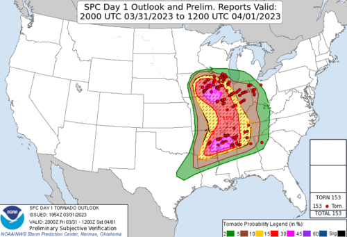
This was a historic outbreak. Based on the preliminary numbers from SPC, there were 153 tornado reports on 3/31. If they verified this would be second only behind the 2011 Super Outbreak for most in a 24 hour period. Update: I agree with Jim Caruso that some individual SPC reports may be of the same tornado. The current total on Wikipedia is 113, which still puts this outbreak in 6th place all-time for a 24 hour period.
1680796572352.png
 
Last edited:
No doubt it was a historic day, but are those stats apples to apples? The SPC numbers are reports and the actual number of unique tornados will probably drop… In the Wikipedia link I assume those are unique tornados since it’s a final tally after all the analysis has been done, but I’m not sure. I could be wrong, just seeking to clarify..

Either way, it’s amazing when you look at the dynamics on March 31, it’s hard to imagine them being more favorable, yet still not enough to make it #1, which shows just how impressive 2011 (and 1974) really were…
 
NWS DVN has now updated their survey and what was previously reported as a single EF-4 tornado is now accurately reported as two distinct separate tornadoes. The first tornado is now rated a maximum strength EF-3 and the second tornado a maximum strength EF-4, the terminus of the first and genesis of the second shown in close proximity to each other.


NWS DVN has now updated their survey and what was previously reported as a single EF-4 tornado is now accurately reported as two distinct separate tornadoes. The first tornado is now rated a maximum strength EF-3 and the second tornado a maximum strength EF-4, the terminus of the first and genesis of the second shown in close proximity to each other.


Glad to see this, this reflects exactly what I and other chasers saw occur southwest of Keota around/just after 4:10 PM.
 
Back
Top