• A friendly and periodic reminder of the rules we use for fostering high SNR and quality conversation and interaction at Stormtrack: Forum rules

    P.S. - Nothing specific happened to prompt this message! No one is in trouble, there are no flame wars in effect, nor any inappropriate conversation ongoing. This is being posted sitewide as a casual refresher.

2024-02-27 EVENT: MO/IA/IL/IN/KY/AR/TN

Models have been in agreement for some time now on a potent shortwave trough translating across the US early next week. With ample moisture return shown taking place following a cold front on Saturday, the synoptics favor some form of an organized severe weather outbreak on Tuesday and possibly into Wednesday.

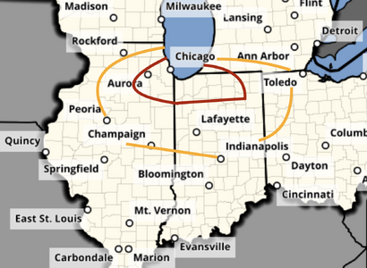
What models agree on now is a broad zone of dewpoints in excess of 60F shown reaching at least the I-70/I-64 corridors in the Midwest with 30kt+ southerly surface flow, as a 50 knot southwest flow at 500mb increases to 70kt into the early afternoon. Beyond that, there many details yet to be resolved.

Potential negatives include the lift arriving early and too strongly with widespread clouds and/or precipitation in the morning. There are some indications of this event extending continuously into Wednesday the 28th as the main trough ejection occurs over the Midwest.
 
It's still early to focus on specifics but there remain some timing and placement differentials, as per usual, with the phasing and placement of upper-level features now that the NAM is starting to come into range through 18Z TUE/27. The system is now in range of the SREF as well which is painting the best mean Sig Tor values across N MO into WC and NC IL and far S WI, owed mostly to the best shear parameters overlapping seasonable moisture influx with NWS model ensemble blends progging to be in the mid-50s. It's interesting to see the placement of the surface low a little further south on the ECMWF, which may shift the risk area a bit further into IL, although true model ensembles would still center a 989 mb low somewhere in E IA proximal to or just south DVN. The ECMWF has been consistently showing what appears to be a prefrontal trough or wind shift ahead of the main CF. This will be something to watch as the surface low tracks somewhere across the mid-Mississippi valley. Historically, if all of the other ingredients come together nicely, that has been ominous more often than not in sustaining initial discrete convection to enhance tornadic potential with otherwise favorable setups in the Land of Lincoln. There has also been an occasional meso-low of sorts showing up near the true warm front into S WI west of the lake, out ahead of the surface low. Some of the surface feature placements look similar to the setup on the 8th save for better moisture this time around. There is a piece of energy that traverses the area earlier in the day although peeking at H7-H85 RH charts indicates a dry punch enters the region before the main lift arrives after 18z. It does appear the CINH holds until closer to the front's arrival. Still, instability isn't overly magnanimous but it is FEB. The real component to watch, besides potential residual convective debris and/or cloud cover, will be the quality of moisture return. There does not appear to be moisture-robbing convection further south with split areas of concern, at least through Tuesday evening, so that works in favor of whatever convection occurs having plenteous moisture, as is seasonably adequate, to work with.
 
Glancing over it this morning, my biggest concern looks to be not so much surface moisture but moisture depth. Most of the outputs I've seen have a very shallow moisture plume. While I do like having a dry slot to work with, I don't like seeing it dry out that close to the surface. The other concern, of course, being timing of the wave. I'm not in a position where I can put in for PTO this close to an event, so I'll be sitting it out, unless there's some late evening stuff near my part of Indiana.
 
It's still early, so there's lots of opportunities for this to change, but:

Just based on this graphic, and knowing that surface dew points are forecast to be in the low 60's and STP values are running 5-7 in the vicinity of the high vorticity/high 3km-CAPE, what speaks against this being a situation one would plan to chase? (I'm can't get there given my schedule, but it never hurts to analyze potential situations for the future.)

CODNEXLAB-FORECAST-2024022521-RAP-NIL-sfc-avort-0-51-100.jpg
 
With CAMs now in range of the event, the most remarkable features of note are 1.) the bona-fide dryline that develops SSW to NNE in central Illinois from around St. Louis northeastward, and 2.) the indications of supercells on a warm front along I-80 & much farther east into northern Indiana than previous guidance. The biggest concern remains with the moisture depth/quality, with models still in disagreement whether we'll get to the 60F mark north of I-64 (outside of moisture pooling on the boundaries), and thus whether substantial capping will prevent convection the warm sector east of the dryline (limiting storms to the cold front).

As to how chaseable this event is - as it looks now, my personal take is that I wouldn't drive more than 6 hours or so for this (anything more than an out-and-back day trip). For a Midwestern chaser, it's a no-brainer. But if this same setup was in western Nebraska or the Dakotas as it appears right now and I had a 12+ hour drive to get to it, I probably would stay home. If the moisture situation improves, my opinion would definitely change.
So, @Dan Robinson is this the dryline you mention (see below)?

1708925689067.png

I confess I didn't look too closely for a dryline before your post. But in looking at it in more detail, I was surprised to see a dryline with such a pronounced Thermal Front Parameter (TFP) signature. (But then, I have only just recently started looking at that parameter.)

(Credit to MetPy for the code used to compute and plot various parameters, thus the logo display.)
 
Attached is my updated tornado forecast as of 4:45pm (you'll find it on my blog).

I use a 4-level risk scale for tornadoes:
  • Significant risk
  • Enhanced
  • High
  • Extreme risk
Red is an enhanced area valid after 4pm and yellow is significant, also valid after 4pm.

The strong dry prod (see Geoff's post above) east of the Mississippi is often a climatological indicator of enhanced tornado risk. The CAM's are showing somewhat greater instability than earlier.

In terms of chasing, it appears to be a better-than-average day.

I'll have an updated forecast on the blog tomorrow morning.
 

Attachments

  • 2-27.png
    2-27.png
    801.4 KB · Views: 14
Boy storms fired quickly, and not hideously far from where HRRR and NAM-3km indicated. (I know it’s a trap to associate CAM forecast cells with real cells that might form, but outcomes like this are hard to ignore )
 

Attachments

  • IMG_0776.jpeg
    IMG_0776.jpeg
    317.9 KB · Views: 8
Back
Top