• A friendly and periodic reminder of the rules we use for fostering high SNR and quality conversation and interaction at Stormtrack: Forum rules

    P.S. - Nothing specific happened to prompt this message! No one is in trouble, there are no flame wars in effect, nor any inappropriate conversation ongoing. This is being posted sitewide as a casual refresher.

2023-02-26 EVENT: KS, OK, TX

Joined
Feb 19, 2021
Messages
551
Location
Wichita
The 18Z ECMWF for Thursday, 23rd is in and -- wow. If this happens to be a "perfect prog" it is going to be a major early-season event.

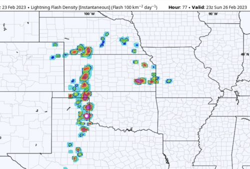
I have attached the lightning flash rate for 23Z Sunday and it shows the storms still discreet along the dry line along with a few cells in the warm sector ahead of the line. Instability for February as far north as Kansas, is extremely high (vs climb) at 1000+ j/kg. The 500mb short wave, with difluent flow over N Oklahoma and S. Kansas, strengthens rapidly as it comes out of the lower Rockies.

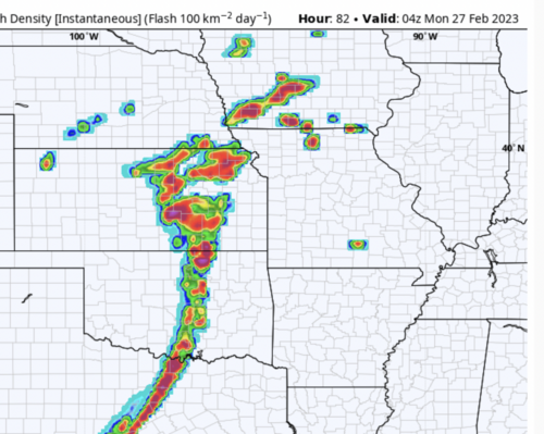
At the surface, the low pressure system shows pressures falling from ~noon to 11pm when the low's central pressure drops to 980 mb near TOP at 06Z. Especially ominous is that temperatures do not drop Sunday evening in Wichita. They stay at the day's high of 59°F. At Eureka (2 counties E of ICT), the high for the day is 62°F, which occurs at 11pm! Similar conditions are forecast to occur in the TUL-MKO area. I did a synoptic climatology of nighttime tornadoes when I was at WeatherData, Inc. and rising evening temperatures + rapidly falling pressure in the threat areas were a common features of ≥F-2 tornadoes that occurred after dark.

My target for late afternoon or nighttime tornadoes would be to take the dry line as shown at late afternoon. From there, the area between I-44 and U.S. 56 seems prime for fast-moving tornadoes. Or, another way: DDC - IXD - TUL - CSM - DDC. The north boundary is the warm front. Of course, this may have to be revised based on later data but this one is well worth watching.
 

Attachments

  • Screen Shot 2023-02-23 at 6.34.24 PM.png
    Screen Shot 2023-02-23 at 6.34.24 PM.png
    1.4 MB · Views: 0
  • Screen Shot 2023-02-23 at 6.50.38 PM.png
    Screen Shot 2023-02-23 at 6.50.38 PM.png
    1 MB · Views: 0
Getting shades of November 16, 2015 from this setup but a bit further east perhaps centered around or just W of I-35. I think moisture quality (how far north it gets and how rich it gets) and storm mode are my biggest questions from this setup. Obviously being 3 days out, it is hard to assess either of these beyond a certain extent.

I will say looking at the low level jet at 03z 02/27 on the 00z Euro, it shows a 65 knot SSE 850mb wind from Northern OK into Southern KS and low 60 dew points with storms ongoing. Pretty impressive for late February for that region. Not to mention looking at the 500mb charts for Sunday evening. No doubt storms will be flying off to the NE at speeds probably close to or exceeding 50 knots (saw some bunker rights at close to 56 knots lol) with that kind of mid and upper level jet streak pushing in.
 
Moisture return is one of my largest questions. There was alot of divergence in the models yesterday on how far north moisture could make it. It appears this will be a "day of" moisture return battle. Hard to believe it is currently 13 degrees with a 7 degree dewpoint here in KS and we are talking severe weather risk in 3 days...
 
I have big concerns about moisture/instability due to the shallow arctic airmass that is entrenched across the plains. As much crap as we give the NAM for its cold bias, it usually outperforms other models when it comes to these shallow arctic fronts. We really need cloud cover to break up over Texas and Oklahoma today and tomorrow to help erode the cold air, and that is likely not going to happen. Once the system begins to eject into the southern high plains, mass low level response will be in full gear, but if that cold air is slow to erode, it will be too little too late for an appreciable tornado threat. Damaging winds will be the greatest threat with a squall line racing east at turnpike speeds. Could see some QLCS spin-ups after dark.
 
Was actually considering an early season warm-up on Sunday but decided against it. Cell speed is a deciding factor, but I'm also wondering if our old friend, a.k.a the western "dust blob" will be playing interference with early cells of interest (see below). I would likely chase as far S/SW as possible, hoping to catch an early cell -- with the blob in mind. Maybe Childress. I'm guessing the SPC will upgrade the outlook at some point to cover hail, wind and QLCS tornadoes after dark.
 

Attachments

  • IMG_2811.PNG
    IMG_2811.PNG
    1.6 MB · Views: 0
Something that jumped out to me this morning while looking through obs was the degree of moisture aloft already over areas much farther north. Looking at vis in south Texas shows some very impressive inland advection already. To the earlier points about the NAM and WRF members handling shallow cold airmasses better, there still seems to be some factors they arent getting right. With 14-15C 850mb dewpoints I'm hesitant to say the shallow airmass will only mixing to what's currently depicted by these members. I do however think the GFS and ECMWF are probably still overdoing things and it unlikely we get a solid 60 F dewpoint to the KS border by 6 pm. But with the kind of mass response we are talking about, there could be some very rapid airmass modification Sunday in southern and central OK. My personal target is south of the Red River. We are going to learn a lot more in the next 12 to 18 hours. I'd pay very close attention to vis and surface trends.
1677265809996.png
 
I don't wish to consider modifying my forecast at this point but I do wish to make a note w/r/t the output from the 18Z ECMWF.

In Butler County, Kansas (El Dorado and Augusta), the model predicts the surface pressure to be 1008mb at noon. By 10pm, the pressure has dropped to 983 mb! In other words, we have the approximate equivalent of a bomb cyclone in Kansas. [The bomb definition is 24 mb in 24 hours.]

We are dealing with an usual situation here.

Addition at 8:53pm. Greg Carbin points out that it will be a record minimum barometric pressure if correct.
 

Attachments

  • Screen Shot 2023-02-24 at 8.52.30 PM.png
    Screen Shot 2023-02-24 at 8.52.30 PM.png
    570.8 KB · Views: 0
Last edited:
Still quite a bit of dry air around, panhandle temps in 70's today but very dry. I still have doubts as to how much low level moisture return will be by the time the system arrives.

1677362962679.png
 
I note that SPC is talking about "strong" tornadoes tomorrow (17Z Day 2) and has gone moderate risk. They have also hatched a zone from west Oklahoma to the Ozarks. I believe winds will exceed 80 mph.

If anyone is interested, I have updated my forecast here: Tornado and Damaging Wind Outlook: 2pm Sunday to 3am Monday

There is a meteorological discussion with my outlook. I am relying heavily on synoptic climatology due to the extreme pressure falls (perhaps a Kansas record) and temperatures (absent rain) rising during the evening. As SPC notes, 0-1km SRH's could reach an astounding 750!

Because of the unprecedented pressure falls and the very early in the year nature of this event, I feel I have to rely on some "old fashioned" tools. My bust potential is high but that is why we are paid "the big bucks" 🙄-- to make difficult decisions to warn the public.
 
If I were chasing tomorrow I would target the Childress, Texas area around 00z for a rogue supercell or potentially a kink in the line (if it goes linear that fast). I'm expecting there could be at least an hour window early on for tornadoes near or just WSW of this area upon initiation.

Could be a fairly widespread early season damaging wind event across much of the target area as well too. Impressive to see the cyclone deepen to sub 980mb over N MO/E IA by early Monday morning. We don't see too many systems with a central pressure that low pass that closely.
 
Kind of a dangerous day tomorrow for chaser and spotters. Since it's a weekend, chaser traffic will likely be higher. This system is so dynamic, it's going to make chasing especially difficult. Dust storms, high winds, nighttime QLCS hazards including the potential for strong (likely brief) rain-wrapped tornadoes and large hail. Storm speed will make interception very difficult. If you don't have a lot of experience, I might avoid this set-up.
 
The moderate risk area expanded this morning due to the wind potential. It is looking like a very damaging wind event setting up and even after the line passes there will be very high winds from the system. I would expect power outages in numerous areas this evening. EF2 or greater tornado threat is looking to be present too.


1677424308651.png
 
There is a toungue of near 50 degree dewpoints across eastern ok into far SE KS
1677431035765.png
Temps here in East Central KS are right at about 50 degrees with thick cloud cover. It sure doesnt have the "feel" of an enhanced risk
 
I would not be surprised to see a high risk issued for the derecho winds with the 2000Z update. Going to be a rare day where almost every severe hazard will be on the "extreme" level.

While I don't think this is an extreme hail day, I just sent a note to SPC inquiring why "EF-2 intensity" winds* (110-135 mph) doesn't equal "high risk"? I'm not sure why it isn't already high risk. I'm glad they expanded the tornado risk, but I think it needs to be further expanded north toward END.

Because this is an EVENT thread, I won't go into my concerns about SPC's risk categories and related issues. Regardless, this should clearly be a high risk day.


*Their forecast in the 1630Z outlook.
 
Pertinent Non-Model Forecasting Technique

Back when dinosaurs roamed the earth (😉), Col. Bob Miller -- in addition to his groundbreaking tornado work -- found that squall lines with a high risk of damage winds were preceded and then accompanied by a (his term) "fall/rise" couplet.

We have one of the most powerful fall/rise couplets I have ever seen today, especially since this is for two hours rather than the more standard three. This pretty much guarantees (in my mind) a powerful derecho.

Above, you'll see my posts about the extreme pressure falls in Kansas. They and this = non-model forecasting technique.

This is the type of thing I am considering putting in a book if there is enough interest.
 

Attachments

  • 4pm 2-26-23 fall rise couplet.png
    4pm 2-26-23 fall rise couplet.png
    2.5 MB · Views: 0
I love me some ground truth methodology!

I also believe the tail end could get true supercells as it interacts with a boundary lifting north from CDS. It's a differential heating boundary. Should intersect nicely with the DL / prefrontal trough.

Trouble is that it'll probably be just after dark. Chasers should also mind storm motion.
 
Banking more on the southern stuff ongoing right now to take off versus the stuff in the Northern Panhandle. If one looks at mesoanalysis at 23z (5pm CST), there is an area of stable air over NW/W Oklahoma with temperatures in the low 60s along with a decent amount of CIN and drop off of CAPE. I wonder how this will impact any storms moving into the environment.

As pointed out above, any storm that could manage to ride along the southern part of this gradient could benefit from the thermal gradient and enhanced SRH it provides....not as if we need any more today lol.

Edit: I notice at 5:16pm they added a tornado warning for the storm I mentioned. I will say the gradient is oriented from NW to SE and storms are flying to the NE at 60+ mph, so it will be interesting to see if we get any long trackers out of this or it is just a brief ordeal with tornadogenesis as they cross the boundary....or perhaps the boundary lifts with them?
 
03Z sounding from OUN before the tornado struck SE part of town. Note the helicity. The fact there was an inversion doesn't matter much when dynamics are this strong. Good thing the inversion was there. View attachment 23483

Saw that this morning and my jaw dropped. I might frame it and put it on the wall. A -333 CIN totally destroyed by a 1000+ 0-1km SRH. I'm assuming there was also a lot of localized help by outflow / inflow interactions and other, yet-to be determined factors. Cannot wait to see a professional write up of this event.
 
Wow looks like Oklahoma went with the Deep South overnight playbook. I read somewhere a modest inversion can actually strengthen overnight inflow. Believe its connected with LLJ mechanics. However that's more like a moderate inversion. The Plains gonna Plains!
 
day1otlk_v_20230226_1200.gif

I've heard several people trying to call what happened on Sunday a "bust". I fail to see the reasoning behind this except from maybe a chasing standpoint?. However most setups with these types of parameters end up being messy anyway with a lot of storms, so I don't know after all these years what people expect? lol. IMO the best "chase" days are the 2% and 5% days that yield that most photogenic results at least from my personal experience. Alas I diverge....

There were A) numerous tornadoes confirmed B) some of which were strong (See Norman/Cheyenne OK/Shawnee for EF2s) and C) widespread destructive winds across most of the original MDT risk area including a 114 mph wind gust near Memphis, Texas. This follows along with the discussion mentioning wind gusts of 80-110 mph along with a few strong tornadoes.

Pretty high end wind event for late February for that particular area. I wouldn't be shocked if additional tornadoes are not confirmed via high resolution satellite in the coming days/weeks....
 
Back
Top