2020-05-13 EVENT: NE/KS/OK/TX

Joined
Mar 2, 2004
Messages
2,384
Location
Northern Colorado
It's been hinted at for days now, and SPC has jumped on board highlighting what arguably could be considered the first central plains chase day of the season for Wednesday. Models continue to support the change in pattern, moving the ridge outta here and setting up southwest flow across the plains. The Gulf opens up thanks to the lack of southward surging cold fronts and moisture starts to return as early as Monday with 60s dews getting as far north as I-80 by Wednesday. Looks like a low develops in eastern Colorado with a dryline setting up and moving into western Kansas with potential triple point setting up. 500mb flow may be a hair bit on the weak side, but good directional turning will support supercells along the dryline. This may be the first in a several day stretch as models keep that SW flow going into the weekend, so perhaps other days will line up. But this definitely feels like the start we've all been waiting for.
 
This setup is kind of reminding me of the week around Dodge City. DC was an outflow boundary on the dryline, which has a chance of happening on Wednesday and beyond. The weaker flow aloft with the more substantial winds near the surface gave a great show in 2016. Leoti, Sweetwater, Turkey, DC and Chapman were all slow moving supercell days back to back and to the best of my memory had a similar pattern to what we potentially have coming up.
The cap seems to be settling into the sweet spot too where we won’t have too many storms crowding the party and without leaving the crowds with a blue sky bust.
I’ve got my rose colored glasses on, but it’s hard not to get excited. Wednesday is in the heart of prime chase territory and if that low stays camped on the OK panhandle, chasers won’t have to make any big moves to chase each day.
 
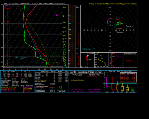
As much as I want to buy in to a classic Plains dryline setup being successful, I'm always leery and pessimistic when I see h5 flow < 30 kts over such a large region. Sure, there are pockets of somewhat faster mid-level flow (still, < 40 kts), but that's going to be hard to predict before game time. The GFS forecast soundings I pulled up (one is attached) show pretty weak mid-level storm-relative flow, which is an indication of storms getting messy fast, even if they start out supercellular (i.e., they'll have trouble staying that way). If a storm happens to slow down even more than the progged Bunkers RMV, then that's a somewhat different story, even though shear itself still won't be great above ~3 km.

But thermodynamics look mostly good, so there are some definite pluses about this setup. If it's close enough for me to feel comfortable on a one-day chase (not yet comfortable going for something requiring a hotel stay), I will definitely pull the trigger on it. I'm Jonesing pretty bad this season.
 

Attachments

  • 2020051000_GFS_093_37.26,-98.16_severe_ml.png
    2020051000_GFS_093_37.26,-98.16_severe_ml.png
    179.5 KB · Views: 0
Quickly losing confidence about this first SW flow transition as a tornado producer. As previously noted, the upper level flow is quite weak and I'm not impressed how models are handing surface features ATM. During a non-COVID year, I might just light the candle and go, but it's going to take more than a marginal set-up to get me moving with the additional risk factor. Later in the week, I suppose the upper levels could increase in speed and backing as the trough approaches, maybe pulling the DL westward, but it's too far out to call.
 
Only the GFS even has much in the way of storms up until 00Z, the SREF and NAM are quite unimpressed.
I just looked at the latest runs. ECMWF, GFS, Canadian, Australian and German all having varying degrees of convection going up anywhere from North Texas to Southern Kansas. NAM is still showing basically nothing yet.
It’s definitely not guaranteed anything will go up at this point and if it did go up that it would be chase worthy. Lots of uncertainty which can only mean one thing. I’m in!
 
This is probably the best Southern plains setup I have seen thus far this year. 500 mb flow is to shift back to where it needs to be after some frustrating NW flow that has dominated the upper air pattern this month. Have to agree with Jeff as WSW 500 mb speed shear on up to 100 mb isn't that impressive but directional shear from the surface up is there. Latest NAM run showing a warm front with very good moisture making its way across Oklahoma throughout the afternoon and evening with warm front along the I-40 corridor in Central OK by 7 p.m. However, 180 mb MLCAPE/shear, CAPE, lift and LCLs are crazy good and cap looks like its going to be limited. 1km Helicity is decent at around 200 m2/s2. Sure, would like to see this around 300 or higher. The pluses far outweigh the minuses on this set up and is definitely worth making a play on, given that the season has been somewhat tame thus far in the Plains. Hopefully things keep trending in the right direction when the NAM 3k comes online tomorrow.
 
I'm really not seeing the tornadoes forming in Oklahoma with the latest readings of the NAM at the moment. To me, it looks like the best spot may be SE KS. The CAPE in Central OK is good enough, but I don't believe there is enough Shear (<35 kts). We'll have to see if the models stay consistent on this, only time will tell.
 
The 9-12 KM winds are screaming HP on top of the already meager mid-level flow; 30 knots reaching a peak of right around 40-45 knots is definitely not encouraging for mode.

Runs of the NAM since 12Z yesterday have slowly worked down the cap with each run but it still looks to be a sizable enough inversion for more isolated convection. The instability has stayed solid as expected with 3500 j/kg^2 of MLCAPE being the baseline for the NAM runs on a corridor ahead of the dryline. Hodographs are obviously small but do have great curvature in the lowest 3 KM with a decent right-mover vector.

I was initially interested in the NW Texas portion of this setup due to relatively deep moisture being in place early in the morning/proximity to me but the spreads out that way are looking increasingly unfavorable. High 80s with LCLs approach 1400-1500 meters at 00Z could make for some pretty storms but I'm not sold on tornado potential for this on the southern end of the dryline. Further north into west central Oklahoma/the Canadian River Valley looks better for tornado potential with any right mover but the weak flow still is concerning for mode.
 
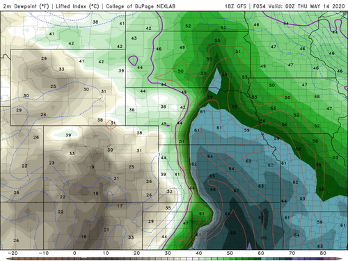
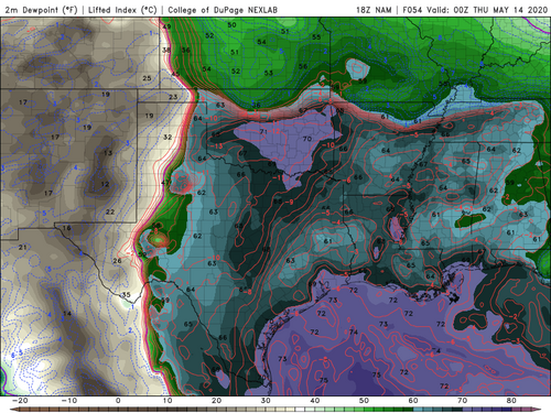
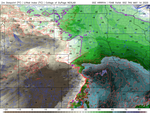
The latest models (NAM, GFS, HRRRV4) still disagree on the setup. The NAM shows a sharp warm front in northern OK, while the HRRRV4 has the front stalled in northern Kansas. The GFS does not really depict the front. This explains the differences in convective probability and location. All models show decent 0-1km shear (>25kts), but they also show weak 0-6km and effective shear (<35kts). I'm going to put my money on the NAM for now and plan a trip to NW Oklahoma.
GFS 18Z Dewpoint North Kansas.pngNAM 18Z Dewpoint.pngHRRR 00Z Dewpoint North Kansas.png
 
Try as I might, I can't find a lot to like about Wednesday, at least thus far. My sense is that an historically poor first third of May has distorted some perceptions of what a respectable setup looks like this time of year on the Plains (and no, I don't mean an outbreak or slam-dunk big tornado day; just a setup where sustained, high-quality supercells featuring some tornado potential are likely).

To me, Wednesday looks more like an event I'd get excited for in March as a chance to dust the gear off. Forecast bulk shear magnitude is marginal at best for sustained supercells, and at least until 00z-01z, low-level shear also appears poor. Most NWP guidance suggests CI on the dryline during the 20-22z timeframe, which I always dislike seeing several hours before decent hodographs are in place. Sufficient moisture for tornado-supportive LCLs is in doubt, with most (though not all) guidance depicting a diffuse moisture gradient where mid-upper 60s dews only exist several counties off the dryline. All these ingredients point to storms birthing and even maturing in a poor environment.

Watching the 00z CAMs post this evening, there is unanimous agreement in outflow-dominant storms with only transient, spotty values of meaningful UH, and large composite cold pools developing by 00z Thu. This scenario has also been hinted at in the QPF output of the ECMWF for several runs. CAM solutions are not the answer to every forecasting problem, but when their depictions of convective mode look this nasty across various dynamical cores and physics parameterizations, I take note.

It's May, and high CAPE will be in place along a dryline, so there's certainly the potential for a tornado or two... but they likely will be very hard-earned if they indeed occur. I won't pretend I'm not chasing, given the proximity, but I've just had such bad luck over the years with similarly flawed setups in this W OK-C KS longitudinal band of the SGP, especially when moisture is less than outstanding.
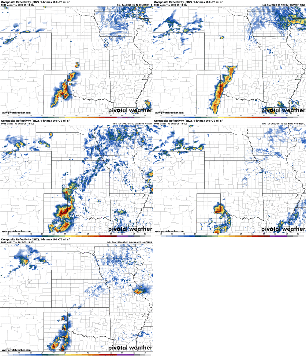
models-2020051200-f048.refcmp_uh001h.us_c.gif
 
T/Td spreads are continuing to go in the wrong direction on this one with LCLs in the 1400-1600 meter range. 12Z NAM seems a bit more bullish on favorable moisture pooling along the US 62 corridor around Hollis but signals for an HP/messy mode with any convection which seems likely given weak anvil level winds that have been a constant since this setup got within 84 hours. This morning's 12Z run of the HRRR progs lower moisture relative to both the NAM and the NAM 3K, with dewpoints not reaching even 65°F by 00Z likely due to some mixing out over the course of the day with surface temps reaching into the high 80s. The HRRR also is displaying far lower instability values than the NAM/NAM 3K, with MLCAPE on the order of 2750-3000 j/kg^2 versus the 3500-4000+ shown on previous runs. Deep-layer shear unsurprisingly remains incredibly poor (25-35 knots on all 3 aforementioned models between 21-00z) with that pointing to a more transient supercell mode with convection unable to maintain in a discrete form before congealing into a line.

I'd maybe take a flier on it and head to Childress or Paducah but I don't foresee much coming out of this one in the way of chase-able storms worth the drive for me.
 
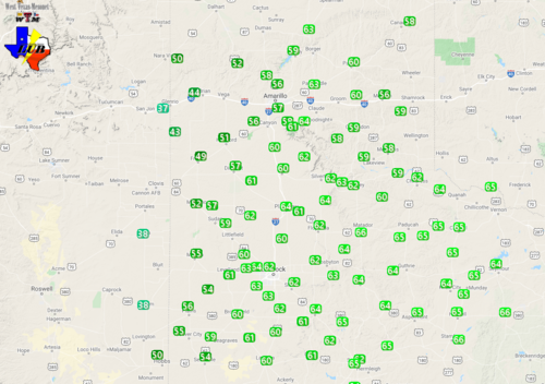
Moisture seems to be very gradually increasing across the west Texas Rolling Plains just off the Llano. High 50s to low 60s heading east towards Childress with pretty meager surface flow thus far. The better moisture is still displaced to the east in the Cross Timbers/I-44 corridor so it'll be interesting to see if this falls in line with the HRRR's lower dewpoint progs compared to the NAM or if moisture can pool closer to the dryline before initiation.

1589385468672.png

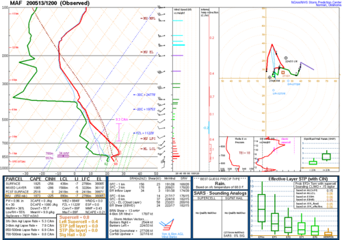
The 12Z MAF sounding below showed a reasonable cap for the time of year with good lapse rates but the moisture depth and the T/Td spread look not great and the continued slow trickle of moisture make it seem likely that LCLs will be an issue for tornado potential on the southern end of this setup, with surface temps already hitting the high 70s/low 80s as I'm typing this.

1589385950981.png

Mid-level flow is exceptionally weak which makes the slightly above forecast upper level winds almost moot for this one. Looks to be a messy day in the Panhandle/NW Texas/ W Oklahoma.
 
Back
Top