• After witnessing the continued decrease of involvement in the SpotterNetwork staff in serving SN members with troubleshooting issues recently, I have unilaterally decided to terminate the relationship between SpotterNetwork's support and Stormtrack. I have witnessed multiple users unable to receive support weeks after initiating help threads on the forum. I find this lack of response from SpotterNetwork officials disappointing and a failure to hold up their end of the agreement that was made years ago, before I took over management of this site. In my opinion, having Stormtrack users sit and wait for so long to receive help on SpotterNetwork issues on the Stormtrack forums reflects poorly not only on SpotterNetwork, but on Stormtrack and (by association) me as well. Since the issue has not been satisfactorily addressed, I no longer wish for the Stormtrack forum to be associated with SpotterNetwork.

    I apologize to those who continue to have issues with the service and continue to see their issues left unaddressed. Please understand that the connection between ST and SN was put in place long before I had any say over it. But now that I am the "captain of this ship," it is within my right (nay, duty) to make adjustments as I see necessary. Ending this relationship is such an adjustment.

    For those who continue to need help, I recommend navigating a web browswer to SpotterNetwork's About page, and seeking the individuals listed on that page for all further inquiries about SpotterNetwork.

    From this moment forward, the SpotterNetwork sub-forum has been hidden/deleted and there will be no assurance that any SpotterNetwork issues brought up in any of Stormtrack's other sub-forums will be addressed. Do not rely on Stormtrack for help with SpotterNetwork issues.

    Sincerely, Jeff D.

2019-05-17 EVENT: TX/OK/KS/CO/WY/NE/IA

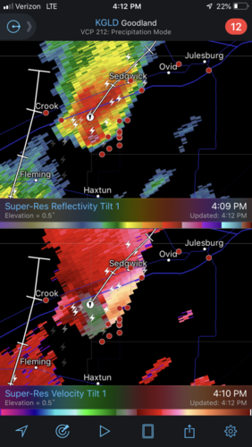
Northern target: Surface winds cranking nicely but failing to back. Worried about resulting weaker convergence on the dryline, although winds behind the DL are pushing decently. Some pesky high cirrostratus/cirrus threatening to interfere with peak heating. RAP has a nice DL bulge NE of Colby, we'll see if we can get and sustain a storm there like the CAMs suggest.

On another note, I've been touring some of the county roads around Colby/Oakley/Grainfield, and everything is dry and in good shape. A few are being graded this afternoon. Of course that will change with storms later, but at least starting out, the road grid looks good to go.
 
In the NEB target area, convection has initiated well southeast of the triple point in the open warm sector. These storms are likely in a decent parameter space yet have no chance of latching onto the frontal boundary. Curious as to why these storms initiated where they did. Will this be the start of the main show or will there be new development back west closer to the surface low and dryline??
 
I’m curious why the storm in extreme northeast CO hasn’t gotten a tornado warning. Looking at radar it appears it may be an L.P. supercell so it’s radar signature hasn’t been all that impressive. However, it has had a solid couplet on it for a while now and it continues to get stronger.
 

Attachments

  • F55AA1D6-5F3A-46B2-B1C4-7DAEF1030825.png
    F55AA1D6-5F3A-46B2-B1C4-7DAEF1030825.png
    465.8 KB · Views: 0
In the NEB target area, convection has initiated well southeast of the triple point in the open warm sector. These storms are likely in a decent parameter space yet have no chance of latching onto the frontal boundary. Curious as to why these storms initiated where they did. Will this be the start of the main show or will there be new development back west closer to the surface low and dryline??

Just taking a glance at the upper air data on mesoanalysis, those cells seem to be co-located with the right quadrant of main 500 mb energy and associated cooling temps AOB -11C. CINH has mostly eroded beneath the cooling aloft in the last 2 hours or so. Surface observations show appreciable pressure falls along and west of the line of convection, from Holdredge, NE to Russell, KS and westward.
 
As previously mentioned, even if that TEC happens in deep SW Texas, the shear environment (IMO) just doesn't look conducive to tornadoes....but then again there's ALWAYS a tornado-warned sup in that area while other storms struggle north of it.


And it's happening again right now, confirmed.
 
@Shane Adams Yeah man, was just looking at that, looks nice on radar, satellite shows it’s perfectly isolated

View attachment 18132View attachment 18133


I'm so upset with myself. Managed to get off work earlier this afternoon and toyed with the idea of heading down towards Big Lake or Ozona to wait and see if anything formed. Second guessed myself and convinced myself nothing worthwhile would happen and hung back here in San Angelo. Whoops. Live and learn I suppose.
 
I'm so upset with myself. Managed to get off work earlier this afternoon and toyed with the idea of heading down towards Big Lake or Ozona to wait and see if anything formed. Second guessed myself and convinced myself nothing worthwhile would happen and hung back here in San Angelo. Whoops. Live and learn I suppose.

Sometimes stuff like that just happens, you can’t beat yourself up over it. Happens to me all the time. I think the road network is pretty bad out there anyway, and I’m sure that tornado was brief if it was even legitimate. May have even been a landspout.
 
Michael Norris said:
I'm so upset with myself. Managed to get off work earlier this afternoon and toyed with the idea of heading down towards Big Lake or Ozona to wait and see if anything formed. Second guessed myself and convinced myself nothing worthwhile would happen and hung back here in San Angelo. Whoops. Live and learn I suppose.
I guess I'm not the only one who toyed with the idea of going out...I also had the afternoon off, just for the heck of it checked the radar to see what was going on in the north/east part of CO. It showed a lineup of cells (still small) north of me all the way to the state line (looking north out my back windows I could even see the southern most one ). I decided against it & ended up doing some stuff around the house instead.

I know atleast a couple of those storms ended up getting severe-warned, but it was in the far north-east part of the state (too far for me)... what I don't know is if I missed any opportunities (even if it was just cloud photos) with that closest cell.

But oh well, atleast I got to watch a separate small thundershower that moved over my area just after dinner.
 
Yep, today will be an exercise in forecast failures. I felt like the moisture just wasn't really making it to SW Nebraska, and I feel things went really early and further down the DL than forecast. The 12Z HRRR did pretty good with storm location, but did not seem to adequately distribute the UH tracks as they seemed to verify.
 
Back
Top