RyanConnelly
Enthusiast
Relative to the past week, it's certainly not much, but a short wave embedded in a belt of modestly strong westerly mid-level flow could create something chase-worthy in the Dakotas and perhaps northern Nebraska for those of us who need something to do on our chasecations!
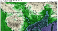
Below is the NAM's first guess at the setup:

Notice the dry line in western ND and central SD, with the NAM resolving a secondary Low along it in western SD allowing for more backed flow in southeast and eastern SD. FWIW the last couple GFS runs have had this signal too.
Obviously, moisture quality is a huge concern, with modeled Td's generally only about 53-55 F in ND, but slightly exceeding 60 F along the Missouri Valley in SD with the aid of extra evapotranspiration, I assume (it's not advected in).
Shear profiles should support supercells, with 0-6 km vectors around 40-45 kts (up to 50 kts on the NAM), and 0-3 km SRH of 200-300 m2/s/2, and CAPE is adequate as well farther south in SD, generally around 2000 J/kg, but more questionable farther north, more like 750-1500 J/kg in ND owing mostly to higher LCLs.
Considering the next day should also feature a severe threat as the wave continues moving eastward into MN, and the long-range doesn't look too great, it's probably worth the drive for chasecationers who are already out there.
tl;dr: dryline/mesolow, low-end but good enough CAPE/shear combo, PBL moisture a big question
Below is the NAM's first guess at the setup:

Notice the dry line in western ND and central SD, with the NAM resolving a secondary Low along it in western SD allowing for more backed flow in southeast and eastern SD. FWIW the last couple GFS runs have had this signal too.
Obviously, moisture quality is a huge concern, with modeled Td's generally only about 53-55 F in ND, but slightly exceeding 60 F along the Missouri Valley in SD with the aid of extra evapotranspiration, I assume (it's not advected in).
Shear profiles should support supercells, with 0-6 km vectors around 40-45 kts (up to 50 kts on the NAM), and 0-3 km SRH of 200-300 m2/s/2, and CAPE is adequate as well farther south in SD, generally around 2000 J/kg, but more questionable farther north, more like 750-1500 J/kg in ND owing mostly to higher LCLs.
Considering the next day should also feature a severe threat as the wave continues moving eastward into MN, and the long-range doesn't look too great, it's probably worth the drive for chasecationers who are already out there.
tl;dr: dryline/mesolow, low-end but good enough CAPE/shear combo, PBL moisture a big question
