2015-07-15 EVENT: NE/KS

Joined
Apr 5, 2010
Messages
223
Location
Omaha, Nebraska
Note: May need to add other states depending on how this turns out.

A day for a summer Chase? Not for me! I've got class! But for some of you Wednesday might be a good day in N KS or E Neb. High Res models showing an MCS forming overnight and spreading into E Neb with a shortwave low. NAM 4km predicts some 20+ SCP and 9+ 0-1 EHI. 0-1KM UD Helicity at 104 predicted with a cell west of Omaha between 0z and 03z, just before sundown. Based on prevalence of LLJ and shear, a couple of tornadoes seem possible before things go MCS, just like the last few days in IL, MO, KS.

Normal NAM doesn't disagree, but puts the action further SW toward the N KS border, and GFS puts a bullseye of 0-3 EHI ~ 13 near Crete, NE. Usually when all of the models agree like this, It's a bust for me....but since I can't chase Wednesday, I think someone has a pretty good shot of catching a couple summer tors, which hopefully won't be HP's, however PW is really high, so watch out for flash flooding on the side roads.

Otherwise, based on the setup, we might be looking at quite the wind / hail event. Soundings are super moist aloft, and I've got a feeling they are overdone, meaning we may have a high downburst potential.

My target (if I could go): Hastings, NE around 4pm, then moving toward Omaha by 8pm.
 
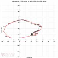
Another fool's gold warm front setup with maxed out STPs? Maybe. However, you can never ignore 50 kts of 0-6 km shear on top of a hodograph like this:

89951d017d3fc37341d4fe3f5d3a278a.png

Now, if there's one thing I learned about this year, it's that an MCS will move through in the morning and trash your whole forecast, but why not give it a shot anyway? I also learned that low-level shear, not corn field instability, more often than not, is the determining factor when forecasting tornadoes in the central plains. Maybe that's a foolish assumption, but anytime I see hodographs like this, I get excited. So here's my noobcast:

The warm front moving northward through Kansas will back winds to mostly ESE, and low-level winds are pretty impressive, giving us those ridiculous hodos. Weak anvil level winds and high PW near 2" will likely lead to HP mode, but shear at 50 kts and mid-level winds AOA 40 kts should be sufficient for conditional supercell development in central/southern Nebraska. The GFS and 4km NAM agree pretty well with the position of the warm front, as well as the progression of the surface trough moving eastward through western Kansas.

Main concerns are will that cap actually break? How strong will it really be? It seems that more often than not, these warm front setups are busts, but that surface trough/wannabe dryline moving in from the west looks like it could provide enough forcing to get the job done. There's also the chance of a lingering outflow boundary from the morning MCS. Also, a combination of 50-60 kts of shear, some capping, and good directional shear should hopefully keep these isolated for awhile, if they don't line out along the warm front. The last concern is a given for 2015; what will that MCS actually leave behind? 2-3k CAPE forecast from the NAMs and GFS is actually pretty low for this time of year in the central plains. This is likely in response to the crapvection that both of the models have lingering around all day. The models don't typically handle these pretty well, so it's a crapshoot as to what is actually going to happen. It may just rain all day and throw out any tornado potential. Or, it could leave behind an outflow boundary that interacts with the warm front and makes some magic happen. Who knows? It's 2015.

If I were to pick a target right now, it would be somewhere between Hastings and Geneva, NE, where I cherry picked that hodograph. I'll see what morning convection does and probably change that target. Hopefully I can get off early enough to actually chase.
 
While the hi-res models are in big disagreement with the NAM and GFS on the placement of the surface low and warm front, the most recent RAP runs have pushed it ever-so-slightly back west, which leads me to believe I should put most of my trust in the NAM for now. The MCS is moving out early, and there appears to be an OFB just northeast of KUEX. If this hangs around and doesn't get washed out, initiation could occur somewhere southeast of Hastings, and move eastward. I've temporarily refined my target to Hebron, NE where there is great road networks. However, with the disagreements in models I have somewhat low confidence in that target until the day moves on and surface observations come in.

P.S. if anyone is chasing today and wants to meet up, I am in need of a chase partner. I'm located in Lawrence. PM me if interested.
 
Last edited:
The MCS in E Neb is coupling with the warm front, which is now pretty clear on the radar. It seems that cells are already trying to root to the surface on the warm side of the front, just behind the stratus deck. This is often a dead giveaway for soon to be intensifying storms. They will likely tap into the enhanced vorticity along the front and could become severe much earlier than expected. Further SW, models are forecasting the warm sector to become crazy unstable, and there will likely be numerous outflows to play with. I'm expecting supercells to form from Hastings toward Beatrice tonight, with maybe a few quasi-supercells further north closer to the shortwave near Columbs before things consolidate around 10pm. The warm sector play could be capped, so the further N / NE you go, the better your chances for storms, but instability could be an issue with storms possible all afternoon.
 
Cell between Manhattan KS and Topeka is turning hard right. Apparently it is riding along the outflow boundary from earlier KC metro storms. This right moving supercell is also on the edge of the hottest mid-level temps, keeping it away from that issue. Cell will also enjoy the right LCLs. As of 7:35 pm Central it had okay rotation on radar. It is my clear favorite cell at the moment.
 
Crossed the warm front and died?
Cell between Manhattan KS and Topeka is turning hard right. Apparently it is riding along the outflow boundary from earlier KC metro storms. This right moving supercell is also on the edge of the hottest mid-level temps, keeping it away from that issue. Cell will also enjoy the right LCLs. As of 7:35 pm Central it had okay rotation on radar. It is my clear favorite cell at the moment.
 
Crossing WF was part of the problem. LCLs were a little high anyway. While dews were plant high, temps in the 90s can still reduce relative humidity. That's one of the rare uses of RH.
 
Back
Top