2015-06-24 EVENT: IA,NE,MO,SD,MN

Joined
Apr 5, 2010
Messages
223
Location
Omaha, Nebraska
Another day 2 ENH with mention of tornadoes! Another possible bust!

If we go back to the forecast for 6-20-15, it's pretty similar. Tons of cape, good shear, warm front pushing up from the south ahead of a low in KS. I Went to Beatrice on 6-20, sat and watched the storms to the south eat up all the WAA and undercut any towers that tried to form. There was also little to no theta-E advection that day, as the winds were blowing from the NE ahead of the warm front, and along it they were pulling in cool air from the cells to the SE. It was hot, sticky, and the Cu field didn't produce until almost dark, and even then re-capped almost right away.

The difference for 6-24-15? HUGE! This time the low is forecast to actually move, instead of stalling in KS. Surface low should be just west of Omaha by 21z Wed, and moving. So now we've got much better trigger for convection, a better warm front (on 6-20 the temps were actually warmer to the north in places), a possible triple point scenario back in NE, and what looks to be lots of theta-E advection.

Two main targets for the day: N MO and all of IA vs E Neb on the triple point. SPC has mostly IA covered for the ENH, but I've got a feeling the low isn't gonna move quite that fast, and E Neb still is a good play.

NAM, NAM 4k, and even GFS pull 4k-5k cape across both targets, with a window for cap to break around 21z, and IA staying open as late as 03z. Shear is forecast to be bonkers long the warm front, as well as near the triple point in E Neb. Surface temps with some silly Td's should be in the 85-90 range and 70-75 range.

Regarding the IA side, some models are saying you should head toward SC IA and N MO, whilst other say stay further toward Des Moines or just west of DM. You also may have ongoing convection to deal with as a complicating factor. Bonus, small Vort-Max possible during the afternoon.

Regarding the Neb side, I'm worried about the dry slot, and the cap. All the models are poking a solid dry slot in pretty quickly, which could mean that only a sliver of the triple point will be viable, likely near Norfolk or Tekamah. As for the cap, just like on 6-20 it's going to be a gamble. Such is summer chases. This time around, however, we've got some major moisture convergence forecast, so things are looking better.

Good luck Chasing! I'll be at work / school Wednesday so the only way catch a TOR is if they come and visit me in Omaha!
 
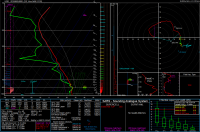
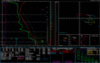
Very nice, Jim! That Supercell Composite of 84 is pretty sexy! Only issues I see are some serious capping at the surface and the ML, meaning if it goes, it might be elevated. TOR could still be a threat, but that sounding really screams gorilla hail to me. You've also got a pretty high PW, so if there is a TOR, it's gonna be HP.
 
This is way too far for me to chase; wish I could. I think the key today is to catch storms crossing or riding the warm frontal boundary, which has been enhanced by this morning's convective outflow. The RAP is showing the best low-level helicity on the IA/MO border west of Keokuk, so that might be the best area to avoid the effects of higher LCLs farther west. Once they get much north of the front the storms will be elevated, but right along the front I would think the chance of a tornado would be pretty good given the rather extreme combination of shear and instability.
 
Another day with completely maxed significant severe parameters. Looking at the 00Z OAX sounding last night I'm actually having a somewhat hard time understanding why things ended up the way they did last night with a messy storm mode. Storm movement to the SSE didn't seem to help matters, but almost should have increased shear based upon this sounding.
20140625-OAX-00Z.png


So what went wrong? Boundary parallel flow?
 
Another day with completely maxed significant severe parameters. Looking at the 00Z OAX sounding last night I'm actually having a somewhat hard time understanding why things ended up the way they did last night with a messy storm mode. Storm movement to the SSE didn't seem to help matters, but almost should have increased shear based upon this sounding.

So what went wrong? Boundary parallel flow?

What do you mean by boundary parallel flow?

It's been awhile since I was educated in such matters, but my intuitive guess as to why more organized storms didn't form is that too much convection went up almost all at once. Seems like with the amount of CAPE present an area of strong convection could be enough to cause significant effects on the surrounding atmosphere (like subsidence). Yesterday, it appears that 2 or 3 areas of strong/organized convection went up in relatively close proximity to each other within the span of about 20 minutes, so I'm thinking maybe all that energy slamming into the tropopause in such close proximity caused messy mesoscale effects that disrupted the dynamics one would frequently see given the synoptic conditions.

I have to agree. Also, insane parameters doesn't guarantee insane visible tornadoes from discrete supercells. Storm mode can easily counteract the effects from a seemingly good environment. Those storms all went up so close together and quickly interfered with each other. Had just a single storm initiated, it may have been something more significant.

Also note from the 00Z OAX sounding the storm relative flow near the anvil was a little on the weak side, thus promoting an HP storm mode even more so.

Also don't be fooled by SB parcels that are thermodynamically distinct from the rest of the profile. Moisture drops off a bit just above the surface, resulting in MLCAPE of only (ha, yeah, ONLY) 3800 J/kg, but with 53 J/kg MLCIN and an LFC 800 m higher than the surface parcel. Those storms were decidedly elevated when they first formed, although I think they quickly rooted, but even then the ML thermodynamics likely were more representative of storm behavior than SB stuff. I tend not to lend much credence to SBCAPE/CIN when there's such a dramatic difference between that and MLCAPE/CIN, because a bad surface ob (I have had discussions with people who fly the raobs who confirm biases in the sensors used to obtain the lowest obs on soundings) can strongly influence the final composite indices in a way that is not realistic. Indices derived from ML parcels are much less sensitive to obs error and are generally more representative, especially in a situation like this (peak heating during the warm season, mostly clear skies).
 
Sorry, a few days away for a friends wedding. Didn't mean to abandon this.

What I meant by boundary parallel flow is that the storms fired off a more or less east/west oriented WF. With mostly western/zonal flow, it seems like mid level and upper flow would likely be mostly boundary parallel. If I've stated that wrongly, please correct me.

And I would have expected HP with such high PW values and low anvil level flow. But everything blowing up at once (high buoyancy) wasn't what I was expecting. Seems like that part of Iowa dodged a pretty big bullet if things had managed to stay discrete/isolated.
 
I agree with Jeff about ML parcels. When forecasting for tors, I have a bad habit of usually ignoring SB parcels, and focusing totally on ML parcels (Call it Nebraska Bias). If the ML LCL is >1250, you're dead in the water. Also if there is a large difference in SB CAPE and ML CAPE, I'm almost always favoring high-based hailers. Storm mode was also an issue, but it should be pretty obvious. If you forecast from only the ML LCL, up, then you've got almost linear shear and little helicty, and would expect a messy or even multi-cellular mode. I didn't think the ML LCL would get up that high on my original forecast, but the surface was a little too toasty, and the 850's a little too dry.
 
If you forecast from only the ML LCL, up, then you've got almost linear shear and little helicty, and would expect a messy or even multi-cellular mode.

This is a good point, and one I meant to bring up in my prior post. The wind profile looks incredible below 3 km, sure, but there's very little to no shear in the 3-5 km layer and the shear is only marginally better (but anticyclonic) between 5-9 km. Given the time of year and with such a deep effective layer, the "deep layer" for good supercell structure is probably deeper than 6 km (in fact, using the effective shear calculation, the top of the "deep shear" layer is around 6700 m AGL), so that weakness in the profile between 3-5 km and switch in the 5-7 km layer probably negatively impact supercell structure. I bet if the hodograph stayed nicely smooth and curved up to 7 km you would've seen more impressive supercell structure. However, storm mode will probably still have impacted things.
 
Back
Top