2015-06-11 EVENT: CO, NE, IA, KS, MO, IL

adlyons

EF2
Joined
Feb 16, 2014
Messages
167
Location
Norman, Oklahoma
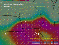
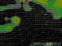
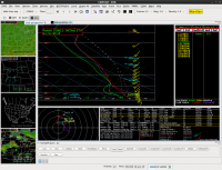
Looking at the possibility of a few severe storms near the surface low moving into Iowa. Looks to be a significant chance of wind and hail and a more isolated tornado threat if cells can manage to tap some of the stronger turning near the warm front. Taking a look at current obs, the gulf is open quiet nicely. 70's dewpoints reside across the south and upper 70's along the coast. High pressure is parked over the southeast which will promote return flow over the next 36 hours. Dews in the target area in central and western Iowa are currently in the low 60's. A cold front is slowly sliding south from Minnesota and will park over the next 12-24 hours. Exact positioning is up for debate but it looks to stall through central/ southern Iowa. Looking up, H5 flow is northwesterly with a ridge to the west. The ridge begins to weaken slightly as the axis shift eastward in response to a closed low coming into coastal California. Diving into model land with the 80 km NAM we see a shortwave trough develop and move into the area early thursday. At the surface a lee cyclone develops on wednesday and attaches to the stalled front over the central plains. It begins translating northeastward along with the shortwave aloft. The low appears to be fairly strong near 1000 mb. This backs the surface winds fairly strongly near the front. ECMWF agrees with the relative strength and location of the low as well as the backed nature of low level flow. With strong moisture good heating and okay shear, severe params jump up. One possible complicating factor is the presence of a decaying MCS from the night before. Hi res guidance has continually placed this in and around the area between 15-18z. However, cloud breaks to the west do show up on several runs. 0-6km shear is also angled to surface boundaries which could mean a messy storm mode with short line segments and semi discrete cells. Soundings from the immediate vicinity of the front show strong instability as well as good turning in the 0-2km layer and moderately strong low level wind fields. 0-6 km shear is 45-50 knots along the front and 35-40 30 miles south. This is adequate One thing to note was that the 10-200 m winds are almost perpendicular to the progged storm motion. This equates to nearly 100% streamwise vorticity ingestion in the lowest level storm relative inflow and is often associated with tornadoes. Sig tor parameter is upwards of 2 which leads me to believe at least an iso tornado threat does exists. I expect a fairly quick transition to an eastward moving MCS with a wind and hail threat. Iso qlcs tors would still be possible. Something to watch over the next few runs.
 

Attachments

  • gfe-VB1.png
    gfe-VB1.png
    360.8 KB · Views: 163
  • gfe-VB2.png
    gfe-VB2.png
    192.6 KB · Views: 159
  • gfe-VB3.png
    gfe-VB3.png
    188.7 KB · Views: 151
12z 4 km NAM looks pretty phenomenal along the warm front in IA taken verbatim, with extreme low level shear (ESRH of 500 m2/s2 or higher) and 2000-3000 J/kg MLCAPE near the boundary. It also seems to want to initiate a string of semi-discrete storms around 21z and move them into this area. Wouldn't rule out a fairly substantial tornado threat being present should this solution be on the right track (actually rule out is probably the wrong term, since it almost certainly would be there), although lingering convection has already screwed up a number of setups this year and will obviously be a factor here too. Still, not exactly a setup I'd want to sleep on if I was living in Des Moines, Ames, etc. These triple point/warm front deals are associated with many significant Iowa events, if not the majority of them.
 
I've only looked at the NAM 12km and GFS, as the NAM 4km tends to over hype everything IMO, but I can't see a scenario in which tomorrow isn't massive squall line or MCS racing through IA. Not much capping and models show crapvection all day with veering winds. Top that off with a cold front crashing in from the west, and it's June. I wouldn't be surprised to see some embedded tors with those hodographs, but given the conditions, it just doesn't seem like there's enough shear to get supercells to me. Maybe I'm just pessimistic because I can't chase, but I think a lot would have to change for tomorrow to be a chaseable day.

My hope is that tail end charlie will light up in NE Kansas and I'll be able to race up there after work, if things haven't totally lined out by then. Both models show better CAPE down there due to the lack of morning precip, but I'm guessing anything down here will be higher based given the 90s temps.
 
I've only looked at the NAM 12km and GFS, as the NAM 4km tends to over hype everything IMO, but I can't see a scenario in which tomorrow isn't massive squall line or MCS racing through IA. Not much capping and models show crapvection all day with veering winds. Top that off with a cold front crashing in from the west, and it's June. I wouldn't be surprised to see some embedded tors with those hodographs, but given the conditions, it just doesn't seem like there's enough shear to get supercells to me. Maybe I'm just pessimistic because I can't chase, but I think a lot would have to change for tomorrow to be a chaseable day.

The GFS is the only model where the shear would be questionable for supercells. Not sure what forecast soundings you were looking at on the 12 km, but the ones I looked at all showed substantial backing in the near-sfc layer with good veering above that. It's one of those setups that could really show its teeth if the early convection isn't as widespread as some solutions show. In addition, forcing with this wave won't exactly favour a rapid transition to linear mode, although the lack of capping like you mentioned could eventually lead to a messy storm mode. I don't see how there won't be tornado potential for a couple of hours after initiation though if the NAM side of guidance is on the right track. This is also really not your classic crashing cold front scenario, given that any "surge" southward is well behind any ongoing convection, except perhaps on the extreme northern end of the risk (and even then that's questionable).

In addition, how does it being June have any influence on what will happen?
 
While 35 kts of shear may be sufficient for supercells in some setups, I'd think with the lack of capping and abundance of forcing you'd need more than 35kts of shear to keep things discrete, in this case. There's more shear in the 18z time frame, but there's also a lingering MCS sitting over most of Iowa at that time. On the 12z NAM from 18-00z you have 30-40 degrees of veering of surface winds with time. I kind of assumed that the southeasterly winds along the warm front in northern Iowa near the triple point wouldn't have a chance at having any kind of discrete convection with the precip forecasts from all of the models, but that might not necessarily be the case. Additionally, soundings near Ames show weakening of the LLJ by 10-20 kts from 18-00z. This setup has potential for sure, but it just seems to me like it will have trouble not going totally linear right off the bat. I think the only hope would be early cells that fire ahead of the line.

June/late summer in general tends to climatologically favor linear MCS modes.
 
Im hesitant to say things will go linear immediately or that this will be an overly significant event. There are many complicating factors here such as overnight convection, boundary placement, exct. But By 21z 6km shear vectors are more perpendicular to the front. While I still think storm mode will be messy, I would expect more semi discrete storms with a quick transition to short line segments. Capping isnt as weak as it is given credit. 12z cinh looks to be 250+ which is more than enough to hold things down till mid afternoon. Prior to 18z cinh is still upwards of 110 which which while weak by EML standard should be fine to limit some of the activity. Looking quickly at a few sharpy soundings it shows some veering of the low level flow near the front per 12z NAM. Again this is something youd expect to see with a june coldfront and you will likely get a messy response out of it. But down stream Iowa looks to have much better turning which leads me to believe supercells are possible. Weak upper level winds would likely mean these storms would be HP but regardless, low level shear looks to favor an iso tornado threat. NAM 4km soundings are very impressive. It has the MCS exiting to the east between 12-16 z which given storms will light in far western Iowa, eastern Nebraska looks to give ample clearing out that way. Regardless this appears to warrant some attention. If things play out perfectly, a significant event could unfold. However that is a big if. Screen Shot 2015-06-10 at 1.56.20 PM.png Screen Shot 2015-06-10 at 2.05.51 PM.png Screen Shot 2015-06-10 at 2.08.27 PM.png
 
Man, where did this event come from? Didn't see too much out of the models lately, but I also hadn't been paying as much attention.

This looks like a fairly potent mid-June shortwave for the Midwest. There isn't really an EML, so we won't be seeing extreme instability, but with surface dewpoints in the upper 60s to low 70s widespread across the southern 2/3rds of IA as well as E NE, E KS, and N MO, and surface temps progged to reach into the 80s to near 90, there will still be strong instability. I think the amount of cloud cover that may remain following overnight into morning convection to the north will play the biggest role in how much instability develops and where storms form.

I'm impressed with low-level flow. There's going to be some serious low-level shear. 0-3 km SRH is forecast to be quite high. Deep shear is marginal for supercells, but in a strongly forced environment with high CAPE, 35-40 kts should be sufficient to get supercells.

700 mb temps are uncharacteristically low for an Iowa June setup. If this lack of capping verifies, that could drive widespread convection, especially if clouds should clear out early. I see that being another potential fly in the ointment.

Other than low level winds being just a tad veered along the cold front, this looks like the kind of setup that could reward chasers who play both the warm front and cold front.

This makes me wish I could make the trip.
 
One area that should not suffer from midday rain is far western Kansas. New jet stream energy will poke out over the Panhandles into western Kansas. Synoptic front and dry line are forecast to intersect in southwest Kansas. I'm afraid the DL will not be a play due to warm mid-levels, high LCLs, and no backed surface winds. Also we need that synoptic front to behave as stationary/warm front, which is only possible in far western Kansas. Cold front behavior is forecast in central Kansas. I'd look for a cell starting to cross the SF in far western Kansas. Also a cell or two north of the SF may be interesting. The above is for a local target in western Kansas, say if one has to work or otherwise can't go far from there. I would not travel for it.
 
Last edited:
This morning looks like a mess. Mid level lapse rates under 6 sampled on the 12Z TOP and OAX soundings as well as poor mid level lapse rates showing up on mesoanalysis. I want to like the Northern IL target at least somewhat along the warm front, but I'm not thinking any tornadoes will be photogenic. I think iowa is a wash and we might see some redevelopment along the cold front in NE KS/NW MO. Not sure why SPC kept the 5% tornado risk at 1630Z up there.

I also think SW KS looks pretty decent, perhaps not for tornadic activity but for some good storms. Lapse rates are 7-7.5 with some decent flow (Sfc-6km shear of 40 knots). I would not be surprised to see a pretty supercell or two in SW KS today.

Wish I could chase, but stuck in the office today
 
Well this event certainly took a turn for the ugly. Overnight convection ended up being much more persistent and widespread than had been previously forecast. It looks like this preceding convection has really wiped out most of the target area I had referred to in my previous post (basically everywhere north of the IA/MO border). However, it also looks like the low itself is going to track much further south than had been previously forecast. This doesn't look like a bust on the synoptic scale, as upper air features haven't changed much over the past several runs. However, it seems this is one of those "banana" lows featuring an elongated and/or curved area of low pressure rather than a more focused local minimum. Thus the forecast MSLP field now looks less like a closed low and more like an inverted trough. There does appear to be something of a focused closed low currently, but over C KS.

The HRRR still shows a tendency for strong storms running along far S IA or the IA-MO border later today, but the best chances for a photogenic show will almost certainly be from extreme SE NE through C KS. Looks like there may be sufficient shear for supercells in KS, but the areal extent looks to be limited. Also, given the crappy mid-level lapse rates, it looks like CAPE won't be as high as one would expect for mid-June with temps in the 90s and dewpoints near 70.

Bummer for upper-Midwestern chasers. Typical Iowa in June, though.
 
Back
Top