• While Stormtrack has discontinued its hosting of SpotterNetwork support on the forums, keep in mind that support for SpotterNetwork issues is available by emailing [email protected].

2013-04-17 MISC: OK

Stan Rose

EF5
Joined
Mar 8, 2006
Messages
513
Location
Pueblo, Colorado
Odd statement in an MCD earlier today foreshadowing things to come: LOW-LEVEL CIRCULATIONS HAVE THUS FAR BEEN MODEST...AT BEST. THIS MAY
BE ASSOCIATED WITH DELETERIOUS STORM-SCALE EFFECTS RELATED TO STORM
SEEDING AND A STRONG VEER-BACK-VEER VERTICAL WIND PROFILE PER TLX
VWP DATA AND PURCELL PROFILER DATA WITHIN THE 2-6-KM LAYER.
Human cloud seeding??? Never seen a statement like that before. Am i reading this wrong?
Hmm that is an interesting statement. I do not recall reading something like that previously. Perhaps someone with first hand knowledge can shed some light on this.
 
Yes, the forward storm this evening was getting precip from the storm behind fall into it. That's what they mean by "seeding." I was on the forward storm all evening, and it gave it several tries, but always seemed to gust out really bad whenever it did. Perhaps this was because of the extra evaporative cooling from precip from the storm behind it? Perhaps it was wrapping in cold air from north of the boundary?
 
A couple posts in the forecast/NOW thread for this day mentioned debris balls with the supercells northeast and south of KFDR. Just thought it might be useful to review what true debris signatures are in supercell storms...

Before dual pol, a tight velocity couplet co-located with high reflectivity in the appendage of a supercell was often called a "debris ball". Of course one can have:
1. a high reflectivity area in the appendage without a tornado
2. a tight velocity couplet without a tornado
3. both high reflectivity in the appendage and a tight velocity couplet, but not virtually co-located, which is then not a debris signature.

With dual pol, this debris signature can be determined with more confidence by combining velocity and reflectivity with a relative minimum in correlation coefficient/rhoHV (for example < .80 (or 80% on GR2AE)).

The supercell near Elgin mentioned in the Forecast/NOW thread had high reflectivity in the appendage, and occasionally a decent velocity couplet (for example the 0020Z volume scan), but they were not colocated. One can see that on the below image. The red dot on all 4 panels is centered on the high reflectivity in the appendage. The yellow dot on all 4 panels is centered on the velocity couplet. They are not co-located, so the high reflectivity in the appendage would not be termed a debris ball pre-DualPol. Looking on the bottom two panels (0.5 and 0.9 degrees CC/rhoHV), there is no relative minimum associated with either the high reflectivity or the tight couplet. Volume scans for this storm after this time also did not show a debris ball/debris signature.

Similar observations could be made about the storm that moved to the south of KFDR.

A lesson on tornado signatures as seen on Doppler radar can be found at http://www.wdtb.noaa.gov/courses/dloc/topic7/lesson12/player.html

oSG1zNX.png
 
Last edited by a moderator:
Jeremy and Tim--thanks, yes i agree that certainly makes more sense, and in context of what you mention that must be what they meant (poor choice of words, cause if you google 'storm seeding' you get dozens of pages of cloud seeding)
 
Thanks for the info GPhillips. I thought for a second perhaps you grabbed your data from OKC but for whatever reason my FDR data did look more impressive and showed better velocity but I don't have a grab to present. Either way, thanks for the link.

I was PMd that there was chatter about a tornado in that location last night. I really just figured NWS was utilizing chaser convergence on all storms to help verify in conjunction with the info you presented. They did torn warn the storm but after the couplet weakened. About 1930ish time frame if I remember correctly.
 
Am I the only one who is of the opinion these SW OK to Central OK storms, were lacking in lighting activity considering their size and frequency and spacing? I'm from the school that if there is not a lot of lightning activity, there may well not be any tornado activity. After a tornado bust on 4 different prime locations, I set up at sunset on the eastern edge of the system west of Purcell for hoping for some lightning captures and they just never materialized. The models missed something and they did a few weeks ago IMO. What's going on? Have they tweaked the models? If so, I vote they revert back where they were last year.
 
I wasn't chasing this day, but from my own personal observations over the years I swear I've noticed several storms that actually tornado immediately AFTER lightning activing has noticeably decreased. I too used to associate this as a sign the storm was weakening, but I don't automatically take that as a given anymore.
Has anyone else noticed this?
 
Am I the only one who is of the opinion these SW OK to Central OK storms, were lacking in lighting activity considering their size and frequency and spacing?

I was on the Lawton area storms and they seemed to go through phases of lightning activity. When the low level structure was ramping up, and most likely the updraft intensifying, there seemed to be a CG barrage. I've got a frame grab in my reports post of a CG behind a wall cloud that was tightening up with some strong rotation and there were numerous other CG bolts within those few minutes. As the storms transitioned into outflowy messes the CG's would subside and we were left with the sporadic CC's. Tornadogenesis and lightning activity are probably tied more to what the updraft is doing, rather than to each other.
 
This was one of those chases where you had to play in the bear's cage to get any intense action. Yet even though we managed to be in the hook for most of the storms we were on, there wasn't a whole lot of hail. When we filmed the first Lawton tornado, we did almost get hit with golfballs, but that's it. Usually big storms like this with strong updrafts seem to lob hailstones everywhere.I knew this entire setup was in trouble when we broke into the warm sector in clear skies to see storms already going at 1:30pm. There were some soundings from the triple point area I saw the shear wasn't lined up until later that afternoon. Overall I was disappointed for trashing good moisture like that due to the veer-back-veer winds, but that's how it goes i guess.
 
The main reason why I think today’s setup didn’t produce as many tornadoes as most people would have thought with multiple supercells in the Frederick to Lawton area was because of the cap, and not because of the “S” shaped hodographs that were in the area. Despite the wind profile in the area with the weakness at 750-800mb flow (showed by the hodograph that Jeff Snyder displayed a few posts ago from the Purcell profiler) and the slight “veer/back/veering” occurring that caused the hodograph to have an “S” shape to it, there were still multiple very organized supercells that formed that, at times, if you were chasing them and saw what they looked like, had rapidly rotating low level mesos that looked like they were about to drop a tornado. The first supercell that formed near Frederick, in particular, at one point, had a barrel meso that looked like it was going to drop a huge wedge tornado. With its appearance and the very rapid rotation associated with it, it was clear that the helicity values in the area were more than sufficient for supercells with a chance of producing tornadoes. Furthermore, when it comes to producing tornadoes, usually as long as the shear is sufficient in the 0-6km layer for supercells, the most important factor for tornadoes is the amount of shear in the lower levels (0-1km). Usually what occurs above that is not nearly as important, as long as the shear in the 0-6km layer as a whole is enough for supercells.

Having been on all of those storms and looking at how their mesos were evolving allowed us to see what we believed was the real problem with the supercells and something we were worried about earlier that day……..the cap. There was a significant cap in the area at 700mb. The 700mb temps were in the 8-9 degrees C range throughout SW OK and they possibly were closer to 10 degrees C in NW TX. That is a STRONG cap for this time of year. None of the models were forecasting any amount of cold air advection to occur in that area throughout the day, so those temps were going to remain constant. Also, by looking at the analyzed 700mb map at 12z that morning, you could see the only area of cold air advection that was occurring was much further to the west. This is a typical problem with positively tilted trough with the cold air advection occurring/staying much further west of the warm sector. Without any cold air advection, significant vorticity advection, and/or any other kind of large scale forcing aloft moving into the area to cool off those 700mb temps, any storms that formed would constantly have the cap messing with them.

The first Frederick supercell, in particular, is what showed this storm/cap interaction occurring. The mesos with this storm were constantly having rapid fluctuations in the amount of rotation with them. One minute, the meso would be rapidly rotating and appeared to be ready to drop a big tornado. A few minutes later, the rotation in the meso would rapidly decrease, along with the amount of scud that was being pulled into it and the appearance of the associated tail cloud would deteriorate. The oscillation of strengthening and weakening of the meso kept going on throughout the life of the supercell. This is a classic indication of the cap messing with the updraft. Whenever the meso was rapidly rotating and tornadogenesis appeared ready to occur, the meso was getting a steady, uninterrupted, stream of surface based parcels feeding into it, which was evident with the meso rotation, tail cloud appearance and how it was feeding into, as well as the amount of scud. The second the cap starting impeding with the stream of parcels into the updraft, the rotation rapidly decreased, along with the amount of scud and the tail cloud started to deteriorate. This rather annoying process was becoming really frustrating to us. We noticed this occurring with the other supercells we were on as well, but it was most evident with the first supercell since it remained as more a classic instead of an HP the longest giving us a clear view of meso without heavy rain wrapping around it.

Being able to see what a supercell looks like on radar, examining it in person, and seeing how it’s interacting with the environment is one reason why I love chasing so much. You can only get so much information about what is going on with a storm on radar. In this case, I think seeing how the supercells were evolving throughout the day really helps to put into light what was the problem with them producing tornadoes, when taking into account what the upper level data was showing.
 
Last edited by a moderator:
The main reason why I think today’s setup didn’t produce as many tornadoes as most people would have thought with multiple supercells in the Frederick to Lawton area was because of the cap, and not because of the “S” shaped hodographs that were in the area. Despite the wind profile in the area with the weakness at 750-800mb flow (showed by the hodograph that Jeff Snyder displayed a few posts ago from the Purcell profiler) and the slight “veer/back/veering” occurring that caused the hodograph to have an “S” shape to it, there were still multiple very organized supercells that formed that, at times, if you were chasing them and saw what they looked like, had rapidly rotating low level mesos that looked like they were about to drop a tornado. The first supercell that formed near Frederick, in particular, at one point, had a barrel meso that looked like it was going to drop a huge wedge tornado. With its appearance and the very rapid rotation associated with it, it was clear that the helicity values in the area were more than sufficient for supercells with a chance of producing tornadoes. Furthermore, when it comes to producing tornadoes, usually as long as the shear is sufficient in the 0-6km layer for supercells, the most important factor for tornadoes is the amount of shear in the lower levels (0-1km). Usually what occurs above that is not nearly as important, as long as the shear in the 0-6km layer as a whole is enough for supercells.

That's a feasible hypothesis, but I'd like to make a few contrasting observations. The relatively early initiation and the radar appearance of the storms doesn't make me think that the cap was a significant problem. Typically, when we talk about capping, it's often in the context of "boom or bust" -- the cap either breaks or it doesn't. Of course, in the real world, it's a bit more complex, as large CINH even in absence of a prominent warm cap atop the boundary layer (such as is the case when the CINH profile is tall and skinny) can reduce updraft intensity (as some "energy" from the updraft is expended to lift the negatively-buoyant surface parcels through the CINH layer). However, after Wednesday's storms initiated, they never really looked to me like they were struggling with a cap. I didn't see any of the west-of-Lawton storms have a highly laminar low-level updraft that I've often seen when appreciable CINH is present. In addition, the radar evolution of the storms didn't really look like they were getting "munched by the cap" per se; the observations you made primarily were only seen with the low-level mesocyclone, which we know is very heavily affected by the structure of the low-level wind field. If it means anything, both the NAM and GFS initializations had ~0 j/kg CINH across the areas where the storms formed, so at least the models didn't analyze a cap. They both showed, however, very prominent S-shaped hodographs.

As you noted, 0-1 km SRH is often thought to be a very effective discriminator between tornadic and non-tornadic supercells (all other things being equal). However, there's more to a supercell's tornado potential than just 0-1 km SRH. After all, we see storms in high SRH often (usually in the southeastern US) that don't produce tornadoes. Anecdotally, however, I still have yet to see an impressive supercell in an environment characterized by an S-shaped hodograph. The rotation of the shear vector IS important when it comes to the linear term of the perturbation pressure equation -- p'_linear = dV/dZ (dot) grad(W) . The perturbation high and low pressure centers would normally rotate clockwise with increasing height in an environment in which the winds veer with height and the shear vector rotates clockwise with height. This allows for preferential updraft and downdraft development that helps supercells move in an "anomalous" direction, which in turn usually increases the SRH.

We know that the low-level mesocyclone is strongly affected by the vertical perturbation pressure gradient force, since the tilting and stretching terms of the vertical vorticity equation are comparatively small in the very lower troposphere. The negative SRH near the 1-2 km layer would be problematic assuming updraft parcels were not exclusively limited to the 0-1 km layer. Indeed, if a parcel near 1.5 km AGL was ingested into the updraft, there would be a tendency for anticyclonic rotation instead of cyclonic rotation.

I've chased a lot of days with s-shaped hodographs, and I almost always see these types of supercells with organized mesocyclones but very sloppy low-level mesocyclones. They also seem to be quite unsteady.

It's also possible that low-level CAPE was rather limited which, combined with a suboptimal low-level wind profile, could explain the messy low-level mesocylones. There were times when low-level rotation was strong, but I saw a lot of very lazy motion at cloud base, hinting that vertical motion and accelerations near cloud base weren't particularly strong.

[Edit: I need to move this out of the REPORTS thread since these aren't chase reports]
 
Last edited by a moderator:
As promised, here's more stuff from my chase. We popped out the other side of the cold front near Childress and Quanah. After letting the first storm roll through Vernon, we waited northeast of town for the next storm that was exploding. Finally caught up to it northwest of Davidson and pretty much stayed within the bear's cage the whole time to Lawton. That's where most of my video comes from is from that storm.

This was somewhere northeast of Frederick. This was as close as a storm gets without producing (see the video)

IMG_2912-XL.jpg


Here we came back into Lawton for the next storm, which I believe was the one that hit the Goodyear Plant. Big scary meso over Ft Sill. After we were cored by this, it produced the tornado east of Elgin.

IMG_2954-XL.jpg

IMG_2956-XL.jpg


Here's an interesting pic, and would like to know if anyone can confirm this as a tornado? This was taken just north of Randlett, OK looking northwest. Another chaser said it was a cone tornado that was quickly wrapped in rain. I'd like to know if anyone else has any insight. I took 2 pics that were a good 15 second shutter and this feature was pretty much similar in shape in both pics before it wrapped in rain.

IMG_2976-XL.jpg


And here's the video from that day.

Watch video >

I'd certainly say that's a tornado Marcus. After playing with contrast in PS you can see a small funnel that appears to be nearly to the ground right above that left light of the group of three.
 
Last edited by a moderator:
That's a feasible hypothesis, but I'd like to make a few contrasting observations. The relatively early initiation and the radar appearance of the storms doesn't make me think that the cap was a significant problem. Typically, when we talk about capping, it's often in the context of "boom or bust" -- the cap either breaks or it doesn't. Of course, in the real world, it's a bit more complex, as large CINH even in absence of a prominent warm cap atop the boundary layer (such as is the case when the CINH profile is tall and skinny) can reduce updraft intensity (as some "energy" from the updraft is expended to lift the negatively-buoyant surface parcels through the CINH layer). However, after Wednesday's storms initiated, they never really looked to me like they were struggling with a cap. I didn't see any of the west-of-Lawton storms have a highly laminar low-level updraft that I've often seen when appreciable CINH is present. In addition, the radar evolution of the storms didn't really look like they were getting "munched by the cap" per se; the observations you made primarily were only seen with the low-level mesocyclone, which we know is very heavily affected by the structure of the low-level wind field. If it means anything, both the NAM and GFS initializations had ~0 j/kg CINH across the areas where the storms formed, so at least the models didn't analyze a cap. They both showed, however, very prominent S-shaped hodographs.

I think that is one of the big misconceptions about the cap when using it in the context of “boom or bust”, where if a storm doesn't fire it means that the cap was “too strong”, and if a storm does fire that the cap automatically just vanished and doesn't exist anymore. That layer of warm air aloft, unless it is cooled in some way, still exists and is ready to mess with any parcel that is not positively buoyant when it rises into that layer. Storms can still fire in regions where there is still CINH in the general area, if there is enough forcing via many different forcing mechanism to make one go up. Once a storm moves away from that forcing mechanism, if the meso is strong enough, it will still be able to periodically force parcels through that layer. This process of sometimes been able to force parcels through the layer and sometime not being able to is why you get cells that, at times, look crisp and very organized, and the next second look very fluffy, as they are starting to evaporate without any parcels rising into it.

Since you have been chasing for quite a while, I’m sure you have seen storms that have gone up, look very crisp, and you can see the rapid vertical motion in the updraft as parcels are streaming upward into the updraft. A few minutes later, the updraft is flurry, the core has weakened, and there isn't very much vertical motion observed in the updraft because parcels are not rising into it anymore. A few minutes later, as a few parcels are able to break through the cap again, intense vertical motion is observed again on a part of the updraft and it starts looking crisp yet again. This is a classic example of the cap trying to “pinch” off the storm throughout its life cycle. The storm never died during this process, but it was clearly been messed with the whole time. This process doesn’t always show up on radar, which is why visuals help out so much since radar cannot tell the whole story. Also, we know the models are good at analyzing some things and can be very bad at analyzing others. One thing the models have a problem with is underanalyzing CINH. I can’t tell you how many times the models, with the RAP being the most prolific offender, show there being 0 CINH, and yet no storms have fired and don’t for hours. Clearly, there must be some type of cap.

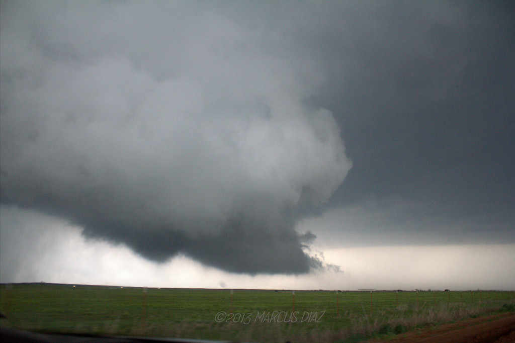
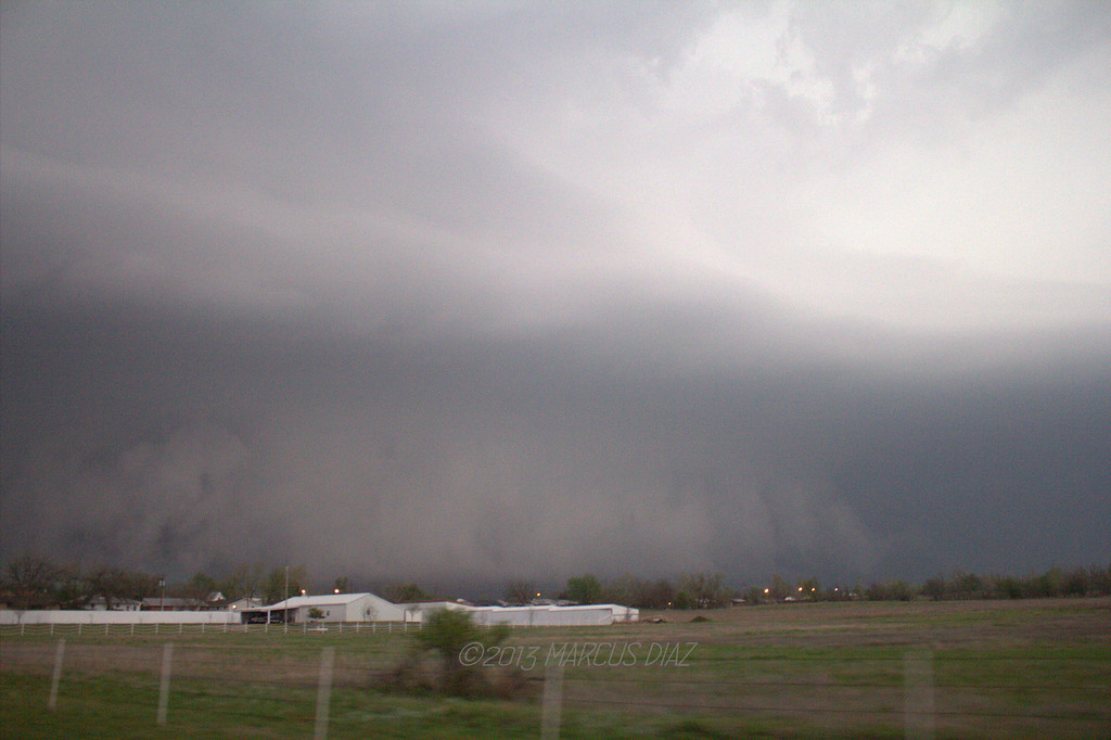
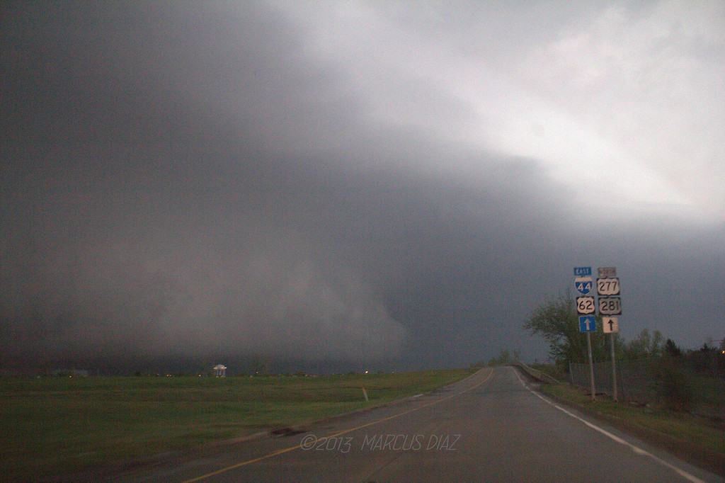
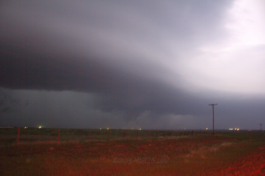
As far as this particular setup goes, I look at the 700mb analyzed map at 12z and 0z, and the soundings, to determine if there was indeed a cap or not, since I know models tend to underanalyze the cap. Looking at the 12z 700mb map, you can see the 700mb temp at OKC were 8 degrees C (high for this time of year), and the temps were even warmer to the south and west. There was SW 700mb flow that entire day in the area without any cold air advection going to move in, so if anything the temps in OKC, and in particular SW OK, could have even increased during that time. To see what kind of surface temperatures it would take to break that kind of cap and keep a sustained (not being pinched at all) updraft, I looked at the convection temperature at a site that closely resembled what the warm setup would be like with comparable moisture and comparable 700mb temps. This sounding would be DFW at 12z. The convective temperature at DFW was 91 degrees F. Now since the 700mb temps there were 11 degrees C and not the 10 degrees, which was being analyzed in SW OK, I shaved a few degrees off that convective temp and said the most optimistic convective temperature would be in the mid 80’s. The temperatures in that area, while the event was ongoing, were in the upper 70’s, with a few low 80’s sprinkled in near the Red River, per the NCAR surface map and OK Mesonet. Those temperatures were not what the convective temperature would be in that area and thus there was definitely CINH in the area. Whatever surface based parcels attempted to rise into that 700mb layer was going to have some issues. Storms were able to go up because there was strong enough convergence along that stationary front and some other N/S oriented boundary (possibly the edge of the 850 jet) that intersected the front that was showing up on radar, regardless of the CINH in that region. There was also some lift that arrived later on from the left exit region of a jet streak at 250mb that could have helped in keep storms sustained later on. Those cells were able to develop mesos that were strong enough to sustain themselves away from the original area of low level lift/convergence that caused them to break the cap in the first place, but they were still having problems sustaining a steady stream of surface based parcels into the updraft, since convective temperature in the area definitely was not reached. Thus, any parcel that was rising into the updraft would have negative buoyancy the second it hit that warm layer around 700mb. That negative buoyancy is something the mesos that day were going to have to fight their entire life cycle. That struggle was evident in the rapid fluctuations in the strength of the low level mesocyclone and the amount of rotation with it.


It's also possible that low-level CAPE was rather limited which, combined with a suboptimal low-level wind profile, could explain the messy low-level mesocylones. There were times when low-level rotation was strong, but I saw a lot of very lazy motion at cloud base, hinting that vertical motion and accelerations near cloud base weren't particularly strong.

Was the strong low level rotation and the lazy motion at cloud base you speak of occurring simultaneously? We saw “lazy motion” at the cloud base too, but that was when the rotation in the low level meso significantly dropped off and other features such as the tail cloud started to deteriorate, which is what gave us the indication that the cap was affecting the storm. Several times, when the first Frederick storm had a barrel, rapidly rotating meso and appeared to be ready to drop a huge tornado, the cloud base motion would definitely not be described as lazy at all.


We know that the low-level mesocyclone is strongly affected by the vertical perturbation pressure gradient force, since the tilting and stretching terms of the vertical vorticity equation are comparatively small in the very lower troposphere. The negative SRH near the 1-2 km layer would be problematic assuming updraft parcels were not exclusively limited to the 0-1 km layer. Indeed, if a parcel near 1.5 km AGL was ingested into the updraft, there would be a tendency for anticyclonic rotation instead of cyclonic rotation.

As far as the negative SRH in that layer, the relative small amount of negative SRH will get completely overwhelmed by the large amount of positive SRH that is being analyzed in the rest of the effective layer. Per the SPC RAP mesoscale analysis, the effective SRH in SW OK was 200 m2/s2 at 22z and increased 300 m2/s2 as 23z. Since the moisture and boundary layer was very deep in the region, the effective layer was around 750mb. This would encompass the 1.5km layer you described with the small negative SRH layer in it and still the helicity values strongly favored tornadic supercells, and in the case of 300 m2/s2…….strong/violent tornadoes.


I've chased a lot of days with s-shaped hodographs, and I almost always see these types of supercells with organized mesocyclones but very sloppy low-level mesocyclones. They also seem to be quite unsteady.


I have also chased many “S” shaped hodographs over the years too. I have been quite rewarded on some “S” shaped hodographs days, with the biggest winner and example of a very good day being March 28th, 2007. I remember the discussion about the “S” shaped hodographs that day also, and it turned out to be a huge outbreak. Pretty much if you chased that day and didn’t see a tornado you were extremely unlucky, as practically all the storms that formed that day produced a photogenic and/or large tornado. The warm sector was littered with “S” shaped hodographs that day, and it didn’t make one bit of a difference because the helicity values were still very sufficient for tornadic supercells. One big difference between that day and 04.17.2013……the strength of the cap. That warm layer aloft and the effects it can have on an updraft with the amount of negative buoyancy a parcel will have rising into that layer should not be underestimated. Many of the "S" shaped hodograph days recently that come to mind that weren't tornado producing machine, I think didn't produce because of the capping issues. This is where actually watching a storm while chasing it sheds so much light into what is really going on, as opposed to what the models are saying/forecasting should be happening with the errors that we know are in them.
 
Back
Top