• A friendly and periodic reminder of the rules we use for fostering high SNR and quality conversation and interaction at Stormtrack: Forum rules

    P.S. - Nothing specific happened to prompt this message! No one is in trouble, there are no flame wars in effect, nor any inappropriate conversation ongoing. This is being posted sitewide as a casual refresher.

1990-06-06: Limon, CO

Joined
Mar 12, 2009
Messages
349
Location
Englewood, CO
I'd like to think that this tornado was what originally got me so interested in severe weather. Granted, I was 12 years old at the time but I remember seeing the damage and destruction on the the news that night and honestly think it was the first time I'd ever been speechless over something the weather had done.

I rarely see footage or pictures of this tornado. It happened around 8PM so it was just around dark and obviously is why not many photo's exist but was just curious if anyone on this board chased this event or had any stories to share about it? I couldn't help but think about it when I was chasing a supercell in Elbert county on June 15th that produced 4 tornadoes. Here I was sitting in Limon 19 years later filming a massive wall cloud in the same city that was practically destroyed by a tornado which led to my interest in storm chasing to begin with. Definitely a full circle type moment for me personally.

The other story out of this tornado that I remember is then Governor Roy Romer had just been exposed to be having an affair with his aide. Bam, tornado happens the same day and the very next day, he's down in Limon with sleeves rolled up, telling everyone things will be okay, and the story of the affair was completely forgotten. Thus coined the term, "Good timing on that one, it's your Limon tornado!" Anyway, like I said, if anyone has any good chase stories about this event, I'm all ears!
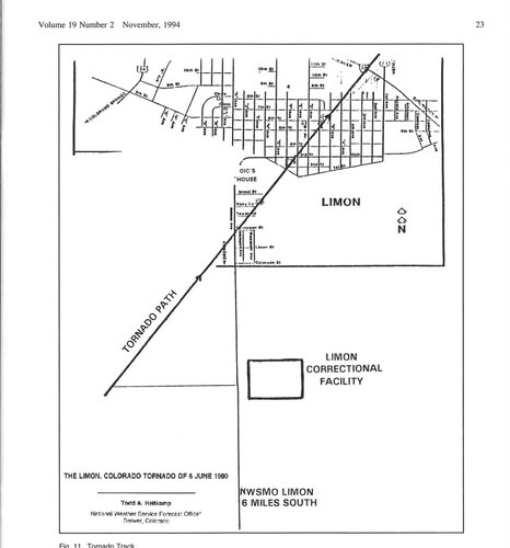
The Limon tornado touched down in Matheson and tore through fields for roughly 16 miles before arriving in Limon. Long track tornadoes like that one are quite rare in that area. I'm on a hunt for photos, and all I'm turning up is various research papers regarding atmospheric instability, mixing, and mesoscale factors, etc. As well as plenty of newspaper results.
 
I too remember this tornado as it happened a couple of years after we moved to Colorado. I remember a professor at Metro State talking about chasing this event in the fall of 1990. His name was Tony Rockwood and he taught Synoptic Meteorology II at Metro during the time. I believe he worked at NOAA in Boulder at the time as well and he and a couple of his coworkers headed out to chase this on the afternoon it happened. I'll have to do some looking around on the internet to see if there are an pictures I can dig up. I'm glad you posted this as I was just thinking about it the other day. If I remember correctly the tornado that hit town was an F3.
 
I remember seeing some footage of this tornado I believe in the TVC series. It looked very similar to the Last Chance tornado that Bill Reid shot. I remember the footage very well because the one guy ran out of "F'n" film. The tornado eventually became rain wrapped as it went into Limon and then they started filming gustnadoes.
 
This event is what really peaked my interest in severe weather and tornadoes. I remember it like it was yesterday. My family and I watched the cumulonimbus build to the east into a tower that was so tall, we were just in awe. I remember the weatherman stating that the top on the storm was like 60,000 feet or something crazy like that. I've never to this day seen a supercell with that kind of vertical structure.

Here's a case study of the event with photos.

http://rammb.cira.colostate.edu/resources/docs/limon.pdf
 
Long track tornadoes like that one are quite rare in that area.

Actually, I'd say they're not as rare as you think. There are a few documented cases of long track cyclic tornadic supercells along the Palmer Divide and into northeast CO. June 1990, the 1993 Last Chance tornado, and the May 10, 2004 tornadofest. There's a few others I can't pinpoint, but know of.
 
I was actively storm chasing in the 90's but at the time I was locked away in a top secret building at Martin Marietta with no windows, radio or any contact with the outside. When I got out of the building at 5pm I could see the line of back-sheared towers out east. It was the most impressive sight I had ever seen from Denver.
 
Larry Green on channel 4 said the storm grew several (60)thousand feet in minutes, alas i was at work :(
 
Actually, I'd say they're not as rare as you think. There are a few documented cases of long track cyclic tornadic supercells along the Palmer Divide and into northeast CO. June 1990, the 1993 Last Chance tornado, and the May 10, 2004 tornadofest. There's a few others I can't pinpoint, but know of.
I agree on all accords... Now that I've looked over the records over the years... I can attest to seeing May 10 '04, right from my old house in Calhan. Here's an image!
WallCloud_fixed.jpg

This is after the two storms merged. Baseball size hail was pretty common throughout the Calhan area, with 1/2 Dollar size hail covering the ground. The wall cloud was rotating pretty fast, it could have produced at any moment. I'm still surprised Calhan didn't set off their siren for that, seeing as the police are pro-active about tornado warnings.
 
Last edited by a moderator:
My experience with the Limon tornado was getting the call at midnight for an "assist other agency," the wee hours drive down there, and working the security, search & rescue from daylight the next day. Emergency services were set up in the police department building. The building seemed perfectly undamaged inside, unless you looked up. The roof was completely gone and open to the sky. And there were generator cables all over the floor for the computers and communications. We were really hoping it didn't storm AGAIN. It didn't; the next day was hotter than blue blazes.
 
I remember that one...infact whenever I hear 'Limon' its the first thing that comes to mind. Really thinking about it, for tornadoes in CO that would be #1 on my memory.
(been too long to remember details or anything .. just the fact there was a strong tornado & bad damage to the town)

On a related note:
There used to be a "Limon Weather Radar" that the TV news would use during weather reports...
At some point that was gone/replaced with the one closer to Denver. What I don't remember was if it was destroyed in the tornado, or simply newer/better systems came online at some point. Just curious, anyone here remember/know that?

The tornado went to the north of the NWS office and co-located radar. This was the WSR-57 radar. The office was closed in the early 1990's and the radar was de-commissioned to make way for the first wave of dopplers.
 
Thanks for posting this topic. The case study is fascinating. I read it several times. As a 1990's chaser, the morning sounding and surface data might not be that impressive on face value -- although in Colorado, 50+ DP's with upsloping (from surface charts), a possible outflow boundary from a eastern MSC (on satellite) and a trough moving in from the west (upper air data) might have raised eyebrows. Unless you had access to updated, remote forecast data (not available in 1990), the forecast might have been seen as long shot. It's still a great lesson on understanding the severe weather meteorology in a fun-to-chase region. I do wonder if the storm would have produced an F3 (or any tornado) if "storm 2" did not interact with it in a favorable (enhancing) manner.
 
Back
Top