10/09/2024 - Hurricane Milton

Joined
Jan 14, 2011
Messages
3,331
Location
St. Louis
Milton is looking to be the second major hurricane to strike the west coast of Florida. Guidance is clustered on a Cat 2/3 landfall on Wednesday midday in the Tampa area, with a significant surge risk for the region.

This looks to be a better candidate for a hurricane chase: major, daytime landfall and lots of available shelter. Still a lot of potential for landfall timing forecast changes to occur. I'm going into standby mode and will make a decision Monday.
 
00z guidance is a little more diffuse on track, slower on timing and lower on intensity. Some more ensemble members are suggesting a more southern track toward Fort Meyers. NHC is maintaining a Tampa track, but slowing the landfall timing to just before 7PM EDT. That's getting awfully close to sunset, any further slowing and we'll be looking at a nighttime landfall. All things considered, my confidence in a chase has gone down somewhat. I'm also not really "feeling" as up to this one either for some reason.
 
Last edited:
"Milton is forecast to move a little south of due east today." That's somewhat good NHC news for Tampa if that trend can continue and impact the overall path. As many of you know, a landfall north of Tampa creates hugely problematic storm surge for that town given the wind direction; the further south towards watering the Everglades, the better, with more off-shore flow for Tampa Bay.
Some of you may remember Neil Frank, the Kansas-born meteorologist that helmed the NHC for more than a dozen years that left there to do on-air weather for Houston in the late 1980s. Thoughts of a big hit on Tampa with attendant, massive surge became his nightmare scenario that he mentioned often. So for the sake of many who already live there, the non-chasers, the southern portion of the cone's better.
 
00z guidance is slower and later for landfall, and even shows some significant weakening beforehand. In addition to the timing/intensity uncertainty, I continue to not have a good feeling about a Milton chase. I am concerned that the expected large-scale evacuations having to funnel through most of northern Florida will greatly increase the necessary fuel reserves needed, beyond what one can safely carry in containers. A chaser simply cannot use fuel that evacuees will need, and so your last fill-up will have to be possibly as far north as southern Georgia. So you're going to be on your own for fuel from there southward, then the entire chase, then the trip out afterward. Not like a Panhandle landfall where once you're 100 miles from the coast, you're out of the fuel shortage zones.

I just don't want to have to spend a week down there waiting for the evacuee return traffic to end so I can get gas and not worry about shortages or taking from someone local that needs it.
 
Last edited:
00z guidance is slower and later for landfall, and even shows some significant weakening beforehand. In addition to the timing/intensity uncertainty, I continue to not have a good feeling about a Milton chase. I am concerned that the expected large-scale evacuations having to funnel through most of northern Florida will greatly increase the necessary fuel reserves needed, beyond what one can safely carry in containers. A chaser simply cannot use fuel that evacuees will need, and so your last fill-up will have to be possibly as far north as southern Georgia. So you're going to be on your own for fuel from there southward, then the entire chase, then the trip out afterward. Not like a Panhandle landfall where once you're 100 miles from the coast, you're out of the fuel shortage zones.

I just don't want to have to spend a week down there waiting for the evacuee return traffic to end so I can get gas and not worry about shortages or taking from someone local that needs it.

The gas situation is yet another part of hurricane chasing logistics that’s hard for me to wrap my head around… How would I possibly deal with that if I have to fly into the area? I’d have to fly in far enough away to be able to purchase gas and other supplies (food, water, etc.). I’d have to buy gas containers for extra fuel. And where would I put them? It is not safe to keep them inside the vehicle, and a rental isn’t going to have a trailer hitch carrier rack or anything like that…
 
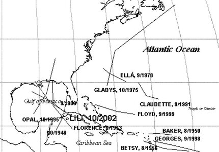
How much will Milton decrease in intensity as it approaches the central Florida coast after earlier increases? Hurricane Lili became the poster child for mercurial change when it rapidly strengthened and then rapidly decayed even quicker upon its approach towards Louisiana in 2002.
This is a common theme after the middle of September according to a Frederick 2003 Weather and Forecasting article linked at the end.
Below: "The 48-h track segments during intensification/decay for 11 hurricanes that intensified at a rate of 35 kt or greater within 24 h and decayed at a rate greater than 24 kt within 24 h of rapid intensification."
Image.jpeg
 
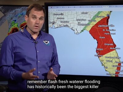
A lot to worry about, though. Powerful (& small) hurricanes that weaken yet grow in areal extent still push a lot of water. NHC states clearly that storm surge could get twice as tall as a person, over heads in areas around Tampa. Similarly clear, over the last decade in hurricanes...see below.
Screenshot 2024-10-07 at 11.46.52 AM.jpeg
 
Last edited:
WOW! Up to 175 mph! Explosive strengthening. Down 22 millibars in 4 hours. Winds up 80 knots in 24 hours - only two hurricanes on record strengthened faster, according to NHC (Wilma in 2005 and Felix in 2007).
 
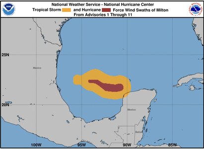
The afternoon update also mentioned hurricane force winds extending out ~ 30 miles from the center: A small, but mighty storm! I’d be curious to see the cross-sectional wind speeds and how they change over that distance. IMG_1254.jpeg
 
Despite this being an amazing storm out in the open Gulf, I’ve made the final call to stand down on a chase. Timing has slowed to the point of a solidly after-dark landfall. Models also have been consistent on the southern (stronger onshore flow) half of the storm significantly eroding/weakening prior to landfall. All things considered, this looks like primarily a surge event (possibly catastrophic) with more conventional wind impacts. If the southern half of the storm vanishes like a few models indicate, only the northern half will present true eyewall conditions in offshore flow, leaving an intercept point for the southern eyewall high and dry (aside from the surge).
 
Last edited:
Tropical Tidbits videos are always enormously informative, but I learned about something I wasn’t aware of in this one - a sting jet. Basically, even if the southern side of the eyewall erodes as to rainfall, shear and barocljnic influences could result in colder air from the northwest sinking down to the surface and causing 120+ mph winds to the south of the eye, despite the lack of precipitation in the southern eyewall. This is discussed starting at about 11:10 in the video and is depicted on the HWRF.

 
Really worried about this one. Most all model have it running right up the bay of Tampa, which happens to be the most worst places in all of the U.S. for a bay direct hit. Nevermind if Milton is a 5,4,or most likely 3 at landfall. The surge and damage will be unbearable. There is a high tide early a.m. on thurs. and that might compound the levels.
I feel for anyone living in the path. Please remind anyone in the area to make preps and or evacuate. hearts go out and I am wishing/praying for the best outcome.
 
Back
Top