09/13/2018 - Hurricane Florence

This is a good sign (the stalling). It may be even be moving slightly SW. The wind shift will help keep any surge waves parallel to or off shore for many locations as the storm winds down. The eye is rapidly filling with clear air and the bands are reducing in intensity. Hopefully, inland flooding will be reduced by the weakening. I'm assuming it will be downgraded to a Cat-1 soon.

I feel rather sorry for TWC. They have done a great job so far, likely the best (and most informative) coverage of a major hurricane yet, but I fear they are now caught up in the inertia of the event like they sometimes do and they are transfixed on one poor reporter struggling in Morehead City as he's battered with silly tropical storm winds and some light rain. I would head to lunch and a beer or two if I was him.

On the larger scale, this could have been a very destructive event had the storm remained a major hurricane and struck the coast head on. I feel very lucky to have dodged a journalistic and historical bullet, antagonized by the minute until Florence's demise became apparent yesterday. I have not looked at enough upper air charts to know if regeneration would be possible if it moves back out into open waters. I sure the hell don't want to miss a Florida landfall..... :eek:
 
....I feel rather sorry for TWC. They have done a great job so far, likely the best (and most informative) coverage of a major hurricane yet, but I fear they are now caught up in the inertia of the event like they sometimes do and they are transfixed on one poor reporter struggling in Morehead City as he's battered with silly tropical storm winds and some light rain. I would head to lunch and a beer or two if I was him...:

I’m sure Mike Seidel wishes he had just gone to lunch and had a couple beers...

https://twitter.com/gourdnibler/status/1040678572262916096?s=21
 
The Weather Channel incident does not help build trust in the media or meteorology community. It is most unfortunate, because storm surge and fresh water flooding did real damage, killed real people, and did happen as forecast.

Appreciate all the coverage from chasers here and elsewhere, but I have no desire to chase myself. Am I am Plains tornado snob? No, but I enjoy watching from my living room with the AC blasting, lights on, and water running.
 
Good day all,

Sorry for the late reply. This is my chase log for hurricane Florence in North Carolina. Details are below...

Summary: This area shows pictures taken from the interception and observation of category-one (borderline 2) hurricane Florence in North Carolina including its landfall on September 13 and 14 mainly near Wilmington and Topsail Beach. Hurricane Florence began its journey as a wave that came off Africa in late August of 2018, taking more than two weeks to reach the United States in mid September. The storm peaked in intensity around September 10 and 11 with explosive intensification, becoming a strong category 4 storm with winds near 150 MPH. As the storm approached north Carolina on September 13, the storm weakened to category 2 with 100 MPH winds, and strong category 1 with 90 MPH as it made landfall on September 14, 2018 near Wrightsville Beach, NC. The chase included a drive from Deerfield Beach, Florida to the primary target area of Wilmington, North Carolina via I-95 north on September 11 and 12, with a stop in Jacksonville, Florida. The chasing was done near Highways 17 and 74 in the Wilmington and North Topsail Beach areas on September 13 and 14. Late on the 14th, I left Wilmington to avoid being trapped by catastrophic flooding by heading back west on Highway 74 to I-95 south, spending that night in Hardeeville, South Carolina. On September 15, I drove back to South Florida, wrapping up the chase with a total mileage on the vehicle (2016 Jeep Wrangler) of 1699 miles. Chaser Derek Sibley also accompanied me on this chase.

florsurf.jpg

Very large and destructive waves impact North Topsail Beach (and North Carolina coastal areas) late in the day on September 13, 2018 as hurricane Florence lingers offshore. The hurricane generated large east and southeast swell waves during its long trip across the Atlantic Ocean and is about 100 miles offshore. The winds are from the north, and actually blowing side-offshore, against the breaking surf, causing spin-drift (back-spray) and a "gnarly" appearance to the 10 to 15 foot breakers. Tides are still above normal with storm surge and wave run-up causing damage to homes and severe beach erosion. Later the storm eye will move in just south of this area, and winds will be onshore and push even more water inland. Shortly after this picture was taken, the entire island was evacuated and all media / storm chasers were told by police to move inland or risk being arrested.

florrad1.jpg

These are two images showing hurricane Florence. To the left is an absolutely incredible image taken by NASA aboard the International Space Station (ISS) as it passed over the storm on September 11. To the right is the base reflectivity of the inner eyewall as it was just about to make landfall near Wrightsville Beach / Wilmington early on September 14.

Full video of Hurricane Florence is below...


Pictures are below...

flor10.jpg

Above: View of North Topsail Beach pier before leaving (police orders) late on September 13 as hurricane Florence draws closer.

flor11.jpg

Above: A BP gas station canopy is topped by strong winds of the outer eyewall of Florence just before midnight on September 13 in North Topsail Beach.

flor14.jpg

Above: Strong winds gusting over 80 MPH and horizontal (sideways) rain at the Wilmington Red Roof Inn during the pre-dawn hours of September 14. This marked the arrival of the inner eyewall.

flor20.jpg

Above: View looking up towards the sky while inside the calm eye of hurricane Florence at about 7:45 AM EDT on September 14 while just SE of Wilmington. The eye was clouded over, with a thin fog / stratus layer, but bright with a warm and muggy environment with skies bright overhead. In this shot you can see ocean birds "caught up" within the eye (there were hundreds of birds noted overhead at one point)!

flor23.jpg

Above: Parts of Highway 74 out of Wilmington blocked by downed trees during the mid morning of September 14.
 
Nice account and pics, Chris. I think Florence packed a wind punch that took some by surprise, being "only" a Cat. 1 after initially being expected to make landfall as a Hugo-like 4. I think the weakening trend had paused at the time of landfall and the hurricane was holding steady, if not slightly re-intensifying as the shear that had been plaguing it abated somewhat and it moved over the Gulf Stream. Unlike some such storms that have come down from their peak upon CONUS landfall, it was not a dried-out "halfacane" that struggled to mix down its winds. Instead, vigorous convection was firing steadily in the core but having difficulty consolidating into a closed off eyewall (not unlike Michael in its first few days). Of course, Michael would soon remind us all what a high-end major is capable of.
 
Good day all,

Andy, I also noticed concentric (but fragmented) eyewalls before the storm came ashore. The outer eyewall seemed to dissapate due to it being over land first, allowing the inner one to re-generate as the outer one was no longer "choking" the iflow layer to it anymore. Very interesting.

Nice account and pics, Chris. I think Florence packed a wind punch that took some by surprise, being "only" a Cat. 1 after initially being expected to make landfall as a Hugo-like 4. I think the weakening trend had paused at the time of landfall and the hurricane was holding steady, if not slightly re-intensifying as the shear that had been plaguing it abated somewhat and it moved over the Gulf Stream. Unlike some such storms that have come down from their peak upon CONUS landfall, it was not a dried-out "halfacane" that struggled to mix down its winds. Instead, vigorous convection was firing steadily in the core but having difficulty consolidating into a closed off eyewall (not unlike Michael in its first few days). Of course, Michael would soon remind us all what a high-end major is capable of.
 
I have finished my long form video of the best parts of my Hurricane Florence intercept in Wilmington, North Carolina/Wrightsville Beach. I tried to include just the most intense parts of the eyewall. Winds gusted just over 105 mph at the Wilmington airport for a while and the pressure dropped down to 958mb according to the kestrel I was using in the eye of the storm. Quite an impressive storm for being just a category 1. I don't have many hurricanes under my belt (4 I think), but this one struck me as exceeding my expectations. Originally I had expected a much stronger storm to make landfall (Cat 3+). However the storm stalled last minute off shore causing upwelling and weakened it a lot. By late night though, new convection fired around the center and winds began increasing per aircraft data. The eye also become significantly more organized just 10 miles prior to landfall as well, so i think there was some intensification going on here. In my experience an intensifying storm (even a Cat 1) will be more intense than a stronger storm that is rapidly weakening. Anyway enjoy.

 
I am not a chaser, but I am a SkyWarn spotter who used to live just north of Wilmington, NC when this infernal hurricane hit going on five years ago. I'd like to take the time to get this off my chest. I will be blunt - I am a weather enthusiast and self-professed weather 'geek' and am not ashamed to admit as much. But if there was ever a time I wished I didn't know what I knew about hurricanes and about weather in general and just claim ignorance, it was in September 2018. When this hurricane was encroaching on my home five years ago my family and I were forced to evacuate since we lived in the low-lying portion of our neighborhood approximately 1.5 miles from the Intracoastal Waterway, mainly due to the rainfall predictions (20-30 inches with isolated totals of 40 in places) and the storm surge forecast.

I was roughly 1 to 1-1/2 weeks post-op on knee surgery to fix a torn meniscus in my left knee and was unable to do much more than pack my things where I could and monitor Florence's track while my parents and sister boarded windows, fueled the trucks and got us ready to leave. The concern as Florence weakened wasn't so much the immediate impact of the rainfall accumulations and storm surge (unless something truly extreme happened), but being cut off from emergency services (Interstate 40 and Highway 17 flooded in places that would have cut us off from the main hospital) in the immediate aftermath in the event that I ended up developing some kind of complications associated with the surgery.

We left at 2am in the morning the day Florence was forecast to make landfall. Normally you can hear the surf from my parents' place if a thunderstorm or even just a good rain storm is off the coast. That morning we left the roar of the surf was nothing short of terrifying. I don't know how many people talk about being forced to evacuate ahead of a major hurricane - even if it weakens before landfall and loses its 'major' status - but I can say from first hand experience that it is very hard on a person emotionally, being forced to leave all but a few things behind, not knowing if you'll come back to anything if at all. It's especially hard when you're trying to be strong for your younger sibling at the same time.

We drove to my grandparents' house in West Virginia - we didn't have anyone further west in NC or in Virginia to stay with at the time and couldn't stay in a hotel since we had two pets with us - a cat and a dog - and had to take into consideration my temporary handicap. We remained with my grandparents for five days (and I am eternally grateful for them taking us in during that time) before it was safe for us to return home. Granted, it took us roughly 3 times as long to return since we had to detour around road closures (and some road closures actually happened just minutes after we passed through some areas east of Raleigh). We had learned before we left West Virginia that everything was still intact, and that our generator was still running, which I was and am still relieved was the end result in our case. I kept in touch with former teammates and classmates from high school who lived in other parts of town who weren't as lucky - their neighborhoods were harder-hit with flooding that resulted in either major damage that was expensive to recover from, or total losses of their homes and belongings due to water damage.
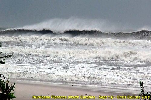

The view of the surf of this was down-right terrifying. This was taken the day before landfall near Topsail Beach, NC.

florsurf.jpg
 
The view of the surf of this was down-right terrifying. This was taken the day before landfall near Topsail Beach, NC.

View attachment 23519

Adding a visual to what I remember hearing five years ago sends chills down my spine even now. If that's what it looked like the day before, I shudder to think what it looked like when my family and I left that following morning.
 
Back
Top