-
While Stormtrack has discontinued its hosting of SpotterNetwork support on the forums, keep in mind that support for SpotterNetwork issues is available by emailing [email protected].
You are using an out of date browser. It may not display this or other websites correctly.
You should upgrade or use an alternative browser.
You should upgrade or use an alternative browser.
Worst SPC Bust Ever?
- Thread starter Bob Schafer
- Start date
Adam Lucio
EF5
This was a bad one in terms of high risk tornado probability placement. I chased this stupid day too...
Brandon Clement
EF4
Adam, that was indeed an aweful day. Those red dots are rather misleading since the cap busted really early, the first couple storms went tornado then everything else just went.
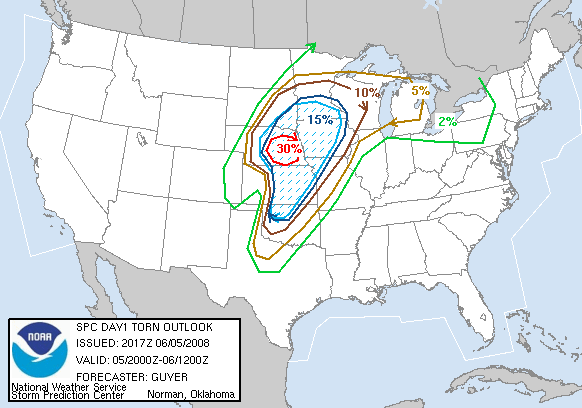
Pretty sure I have the winner here. Another high risk day that I chased and was back at home by 3pm because it was painfully obvious what the day would bring despite the high risk.
http://www.spc.noaa.gov/products/outlook/archive/2005/day1otlk_20050411_1630.html
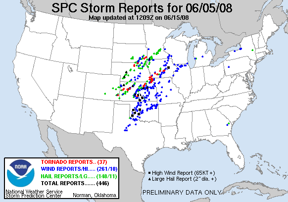
Reports
http://www.spc.noaa.gov/climo/reports/050411_rpts.html
2 brief tornadoes, neither verified. 1 was barely in the slight risk area. 25% hatch for tornadoes.
No significant wind reports
No significant hail reports despite a 35% hatched area in the SE and a 25% hatched area in the plains.
If I remember correctly there were only one or two tornado warnings even issued that day, all on embedded junk.
Pretty sure I have the winner here. Another high risk day that I chased and was back at home by 3pm because it was painfully obvious what the day would bring despite the high risk.
http://www.spc.noaa.gov/products/outlook/archive/2005/day1otlk_20050411_1630.html
Reports
http://www.spc.noaa.gov/climo/reports/050411_rpts.html
2 brief tornadoes, neither verified. 1 was barely in the slight risk area. 25% hatch for tornadoes.
No significant wind reports
No significant hail reports despite a 35% hatched area in the SE and a 25% hatched area in the plains.
If I remember correctly there were only one or two tornado warnings even issued that day, all on embedded junk.
Last edited:
Adam Lucio
EF5
This one is from my chase log on this day. Classic 15 hatched bust. That little red dot in NW IL was actually a briefly photogenic tornado as well.

Dean Baron
Supporter
This was a bad one in terms of high risk tornado probability placement. I chased this stupid day too...
This one was brutal. Only high risk I've ever chased.
June 18th, 2009 was pretty bad too across northern IA/southern MN. Luckily 364 days later MN would redeem itself for many people. Here's the 15% hatched TOR for 6/18/09 without a single tornado in that area in MN/IA.
http://www.spc.noaa.gov/products/outlook/archive/2009/day1otlk_20090618_2000.html
Storm Reports:
http://www.spc.noaa.gov/climo/reports/090618_rpts.html
Rich Thompson
EF3
Bummer that I didn't notice this thread until now! I'd like to reiterate what Tim S. mentioned above - SPC outlooks are about more than a chase forecast. Lots of people look at them, and many are not terribly happy when we bounce around from update to update. Moreover, there are many tough forecast scenarios where there is genuine disagreement amongst the forecasters on the potential outcomes. Some have a tendency to forecast what they see as the "worst case" scenario, while others default to what they see as the "most probable" scenario. The scenarios and the forecasters vary by the shift, the day, and the week.
In my experience, the most consistent source of over-forecasts is aggressive extended outlooks (day 2 and beyond) that carry through to day 1. Downgrading is not for the faint of heart, since you must overcome lots of forecast "inertia" related to previous planning inside and outside the NWS. Also, when you downgrade, you'd better be right! I was off work and chasing the 5/16/15 event so I can only speculate about the reasons for keeping the MDT risk in KS with the morning outlooks.
I've had my fair share of busts in 21 years of convective outlooks. The one Adam L. posted was a case where I should have downgraded at 1630z and didn't:
Greg McLaughlin
EF5
The worst bust I can remember was a high risk in Oklahoma in 1994 or 1995. Total cap bust. May 1, 2010 was quite the bust. What about surprise tornado busts? Hutchison, KS tornado on July 13th was quite the surprise. Hammond, OK is another one. There was a no storm risk day back in the 90's where a supercell formed in the northern Texas panhandle and produced a highly photogenic tornado which lasted nearly 20 minutes.
Today (22 Aug 2015) won't be the worst bust, but it was definitely a bust.

Last edited:
I wasn't in front of my computer all day, but I don't remember ever even seeing a tornado warning today and there were tornado watches from the Canadian border all the way to Kansas. Very few severe thunderstorm warnings too all day long.
calvinkaskey
Guest
- Joined
- Feb 17, 2014
- Messages
- 384
Lol, I got 7 minutes of video from one of the red dots in Eastern N.C. that day. TWC did say a high chance of tornadoes in N.C. that day.This one is from my chase log on this day. Classic 15 hatched bust. That little red dot in NW IL was actually a briefly photogenic tornado as well.

calvinkaskey
Guest
- Joined
- Feb 17, 2014
- Messages
- 384
http://www.spc.noaa.gov/climo/reports/150719_rpts.gif This was a bust for my area as the middle of enhanced chance fell on the western edge of reports in N.Y. In the morning there might have been a marginal chance in coastal New Hampshire but they had baseball sized hail.
Taylor Wright
EF2
Let's see itLol, I got 7 minutes of video from one of the red dots in Eastern N.C. that day. TWC did say a high chance of tornadoes in N.C. that day.
calvinkaskey
Guest
- Joined
- Feb 17, 2014
- Messages
- 384
That's kind of hyperbolic, saying that day belongs in a thread titled "Worst SPC Bust Ever". Verification of 13Z outlook from that day.
http://www.spc.noaa.gov/products/outlook/archive/2015/day1otlk_v_20150719_1300.gif
http://www.spc.noaa.gov/products/outlook/archive/2015/day1otlk_v_20150719_1300.gif
Rick Schmidt
EF3
Also, it appears that your video does not confirm a tornado, just a funnel. You may have seen something visually; it just does not show any contact with the ground.
Similar threads
- Replies
- 11
- Views
- 531
- Replies
- 11
- Views
- 2K
- Replies
- 4
- Views
- 1K