
-
A friendly and periodic reminder of the rules we use for fostering high SNR and quality conversation and interaction at Stormtrack: Forum rules
P.S. - Nothing specific happened to prompt this message! No one is in trouble, there are no flame wars in effect, nor any inappropriate conversation ongoing. This is being posted sitewide as a casual refresher.
You are using an out of date browser. It may not display this or other websites correctly.
You should upgrade or use an alternative browser.
You should upgrade or use an alternative browser.
Worst SPC Bust Ever?
- Thread starter Bob Schafer
- Start date


Hannah.Taylor
EF4
I want to know why NWS cancelled most of KS for the Mod Risk area, only to turn around and issue a MD for WRN KS then a short time later turned around and issued a Tornado Watch for WRN KS, which never produced anything more than a SVR WAR storm.
I saw that and I just scratched my head for 2 hours over that one.
I saw that and I just scratched my head for 2 hours over that one.
Brandon Centeno
EF1
I think it largely had to do with uncertainty surrounding destabilization of the overturned airmass.
This was a tough one to forecast. The MDT at 06Z was justified IMO due to ominous forecasts from many models including the NAM flavors and some CAMs along with radar observations of convection that was not becoming significantly widespread or intense. I'm a little surprised they stuck with it as long as they did, but the uncertainty with this forecast probably justifies what they did.
This is far from the worst bust I have ever seen from SPC. One bad one I remember was 26 June 2011, when they went with a 15% hatched tornado risk, in which only two reports ever followed.
http://www.spc.noaa.gov/products/outlook/archive/2011/day1otlk_20110626_1630.html
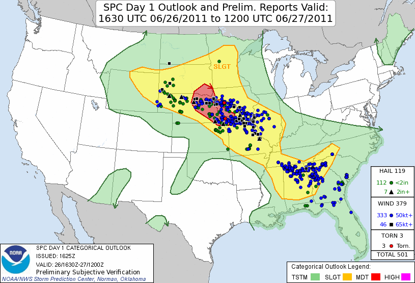
This is far from the worst bust I have ever seen from SPC. One bad one I remember was 26 June 2011, when they went with a 15% hatched tornado risk, in which only two reports ever followed.
http://www.spc.noaa.gov/products/outlook/archive/2011/day1otlk_20110626_1630.html
Brandon Centeno
EF1
Yes those who stayed up late would've seen some very potent/high-impact runs from CAMs and high res models. MPAS had a ridiculous UH/reflectivity field Kelton posted and at the time matched almost exactly with the HRRR on overnight convection. It was looking like a dangerous day. The morning cloud cover and lingering convection put a huge dent in that.
I must say I was expecting everything north of the outflow boundary to be removed from the moderate risk by 11:30 update.
I must say I was expecting everything north of the outflow boundary to be removed from the moderate risk by 11:30 update.
Marcus Diaz
EF5
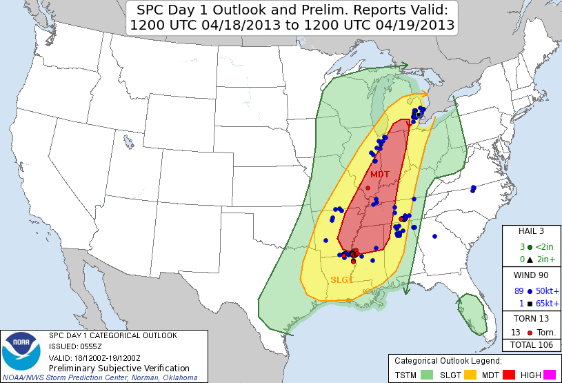
Anyone want to pull up April 17, 2013? Because that was probably the worst SPC bust ever. Today had several tornado reports including one violent and long track tornado with some very large hail (baseballs or bigger).
Last edited:
Dan Robinson
EF5
I was a little puzzled by the 1300 and 1630 15% north of the OK-KS border. When I woke up (too late) in North Platte, my heart sank at the surface plots - the warm sector was just decimated beyond hope all the way to Oklahoma, with sub-60s DPs in the KS and NE segment of the outlook. I'm not trying to be critical, I'd like to learn if I missed something myself in thinking there was no way we would see tornadoes in that environment, regardless of model indications.
Bob Schafer
EF5
This was a tough one to forecast. The MDT at 06Z was justified IMO due to ominous forecasts from many models including the NAM flavors and some CAMs along with radar observations of convection that was not becoming significantly widespread or intense. I'm a little surprised they stuck with it as long as they did, but the uncertainty with this forecast probably justifies what they did.
This is far from the worst bust I have ever seen from SPC. One bad one I remember was 26 June 2011, when they went with a 15% hatched tornado risk, in which only two reports ever followed.
http://www.spc.noaa.gov/products/outlook/archive/2011/day1otlk_20110626_1630.html
[Broken External Image]:http://www.spc.noaa.gov/products/outlook/archive/2011/day1otlk_v_20110626_1630.gif
So how, in what way, is this bust worse than 150516? In the example you cite here, the MDT area is smaller than the 150516 MDT area, and there is one tornado report vs. the area I have referenced (north of I-40) which had zero tornado reports.
Bob Schafer
EF5
Today had several tornado reports including one violent and long track tornado with some very large hail (baseballs or bigger).
Not in the area I highlighted. I never disagreed with the MDT (https://stormtrack.org/threads/2015-05-16-event-tx-ok-ks-ne-sd-ia-mo-mn.28414/page-2) south of I-40, but that is not what this thread is about.
Last edited:
Tim Supinie
EF2
Rich Thompson actually had some insight on this in the last session of his tornado forecasting workshops. Essentially, SPC tries to cover every possibility, and one of those possibilities (at least at the beginning of the day) was that the air mass would recover. I've also noticed a reluctancy to change risk areas significantly before the 01Z update, which is probably to avoid flip-flopping on the forecast. They hear about that when it occurs. I'm not saying these are keys to making a good forecast, but the SPC has to deal with a lot more than someone making a chase forecast would.
But at the end of the day, why are we monday-morning-quarterbacking the SPC? The SPC is not a great way to make a chase forecast, and you guys know that. If you feel you made a good forecast on Saturday, congratulations! If you didn't, then hopefully you learned something and won't make the same mistake again next time.
But at the end of the day, why are we monday-morning-quarterbacking the SPC? The SPC is not a great way to make a chase forecast, and you guys know that. If you feel you made a good forecast on Saturday, congratulations! If you didn't, then hopefully you learned something and won't make the same mistake again next time.
Jake Orosi
EF4
I wouldn't call it a bust. All those dots in Oklahoma north of the Red were all in the 15% area.
James Wilson
EF5
Why is it that all of my worst busts are around DDC? If it wasn't for Garden City 4-29-09 I would have nothing in SW KS.
Logan Karsten
I don't know if I would call Saturday a complete bust for SPC, but I was somewhat perplexed by the expansive 15% hatched area they introduced for the day 1. One of the reasons I didn't make the trip down to the southern plains Saturday was the model spread and uncertainty of the event. NAM was the most bullish on doomsday scenario for Oklahoma. However, the GFS was consistently breaking precipitation out over the region, keeping instability at bay. What ended up happening was somewhere between the NAM and GFS. I don't think it was a mistake to introduce a 15% tornado hatched for that day. I do think it was a mistake to outline such a large area given the mesoscale uncertainties that existed even the night before.
Royce Sheibal
EF3
I was a little puzzled by the 1300 and 1630 15% north of the OK-KS border. When I woke up (too late) in North Platte, my heart sank at the surface plots - the warm sector was just decimated beyond hope all the way to Oklahoma, with sub-60s DPs in the KS and NE segment of the outlook. I'm not trying to be critical, I'd like to learn if I missed something myself in thinking there was no way we would see tornadoes in that environment, regardless of model indications.
I think the lesson we need to learn here is the importance of return flow up north (Here in Nebraska, etc) this early in the season. I've lost count of how many times we've had a great setup, only for crapvection or cloud Debris to not only ruin heating....but most importantly return flow. A large MCS cuts off theta-e advection, which is critical to fueling a good cape, in addition to disrupting moisture convergence (a critical factor up here for frontal storms), and can even mess with low and mid-level shear upstream. Upstream in Nebraska we got hit with the quadruple whammy, no heating, no theta-e, no convergence, ruined shear.
Interesting Note: Further east of the main area, in E Neb, we had instability storms fire up and had a decent return flow form the south (ahead of the MCS). Storms fired in SE Neb, were not severe, went over into Iowa, and dropped a couple TORs once the environment recovered. Too bad I refuse to chase in Iowa.
Ethan Schisler
EF5
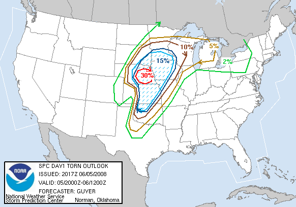
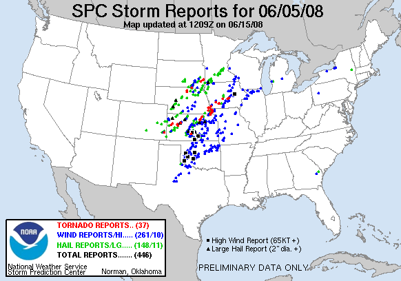
This one comes to mind for me as the "worst bust". They even went as far to issue a PDS Tornado Watch for most of Indiana where not even a single severe weather report occurred.
Ben Holcomb
EF5
Adam Lucio
EF5
This was a bad one in terms of high risk tornado probability placement. I chased this stupid day too...
Brandon Clement
EF4
Adam, that was indeed an aweful day. Those red dots are rather misleading since the cap busted really early, the first couple storms went tornado then everything else just went.
Pretty sure I have the winner here. Another high risk day that I chased and was back at home by 3pm because it was painfully obvious what the day would bring despite the high risk.
http://www.spc.noaa.gov/products/outlook/archive/2005/day1otlk_20050411_1630.html
Reports
http://www.spc.noaa.gov/climo/reports/050411_rpts.html
2 brief tornadoes, neither verified. 1 was barely in the slight risk area. 25% hatch for tornadoes.
No significant wind reports
No significant hail reports despite a 35% hatched area in the SE and a 25% hatched area in the plains.
If I remember correctly there were only one or two tornado warnings even issued that day, all on embedded junk.
Last edited:
Adam Lucio
EF5
This one is from my chase log on this day. Classic 15 hatched bust. That little red dot in NW IL was actually a briefly photogenic tornado as well.

Dean Baron
Supporter
This was a bad one in terms of high risk tornado probability placement. I chased this stupid day too...
This one was brutal. Only high risk I've ever chased.
June 18th, 2009 was pretty bad too across northern IA/southern MN. Luckily 364 days later MN would redeem itself for many people. Here's the 15% hatched TOR for 6/18/09 without a single tornado in that area in MN/IA.
http://www.spc.noaa.gov/products/outlook/archive/2009/day1otlk_20090618_2000.html
Storm Reports:
http://www.spc.noaa.gov/climo/reports/090618_rpts.html
Rich Thompson
EF3
Bummer that I didn't notice this thread until now! I'd like to reiterate what Tim S. mentioned above - SPC outlooks are about more than a chase forecast. Lots of people look at them, and many are not terribly happy when we bounce around from update to update. Moreover, there are many tough forecast scenarios where there is genuine disagreement amongst the forecasters on the potential outcomes. Some have a tendency to forecast what they see as the "worst case" scenario, while others default to what they see as the "most probable" scenario. The scenarios and the forecasters vary by the shift, the day, and the week.
In my experience, the most consistent source of over-forecasts is aggressive extended outlooks (day 2 and beyond) that carry through to day 1. Downgrading is not for the faint of heart, since you must overcome lots of forecast "inertia" related to previous planning inside and outside the NWS. Also, when you downgrade, you'd better be right! I was off work and chasing the 5/16/15 event so I can only speculate about the reasons for keeping the MDT risk in KS with the morning outlooks.
I've had my fair share of busts in 21 years of convective outlooks. The one Adam L. posted was a case where I should have downgraded at 1630z and didn't:
Greg McLaughlin
EF5
The worst bust I can remember was a high risk in Oklahoma in 1994 or 1995. Total cap bust. May 1, 2010 was quite the bust. What about surprise tornado busts? Hutchison, KS tornado on July 13th was quite the surprise. Hammond, OK is another one. There was a no storm risk day back in the 90's where a supercell formed in the northern Texas panhandle and produced a highly photogenic tornado which lasted nearly 20 minutes.

calvinkaskey
Guest
Lol, I got 7 minutes of video from one of the red dots in Eastern N.C. that day. TWC did say a high chance of tornadoes in N.C. that day.This one is from my chase log on this day. Classic 15 hatched bust. That little red dot in NW IL was actually a briefly photogenic tornado as well.

Similar threads
- Replies
- 1
- Views
- 351
- Replies
- 20
- Views
- 3K
- Replies
- 1
- Views
- 136