• While Stormtrack has discontinued its hosting of SpotterNetwork support on the forums, keep in mind that support for SpotterNetwork issues is available by emailing [email protected].

Worst places to chase?

Joined
Mar 28, 2016
Messages
42
Location
Hyannis, MA
I have seconded the notion that Missouri is one of the worst places to chase, it's true that the road network is pretty spotty in places (happened to me once on a local chase out in Warren County) and the terrain leaves a lot to be desired. Where I live now it's pretty bad (New England) because of roads and terrain plus the large urban areas. Another less than desirable place to chase would be those counties in Illinois that front the river, the bluffs make for interesting and irritating situations.
 
Arkansas is pretty bad as well. Parts of Eastern Oklahoma, even a few areas in Southeast Kansas are fairly bad as well. The general rule is west of I-35 is the best terrain when it comes to the plains for chasing, at least in Kansas/Oklahoma/Texas. I live in Illinois and have found most of Central Illinois to be quite good terrain for storm chasing along with a paved road network and good cell data (except for the Quincy area!!).
 
Arkansas is pretty bad as well. Parts of Eastern Oklahoma, even a few areas in Southeast Kansas are fairly bad as well. The general rule is west of I-35 is the best terrain when it comes to the plains for chasing, at least in Kansas/Oklahoma/Texas. I live in Illinois and have found most of Central Illinois to be quite good terrain for storm chasing along with a paved road network and good cell data (except for the Quincy area!!).

Macoupin County, Illinois is very good for chasing. Spent some time there. I was talking about places like Calhoun County. Calhoun is bad with all the hills.
 
For those of you who frequent the central plains, Nebraska is pretty much 100% chasable, outside of that patch of Cherry county with no roads for 50 miles in any direction. I've found a few spots in North Central Kansas where roads aren't really roads, more like dirt paths with washouts in the middle. Clay Center area. Moral of Story: Stick to Pavement and make sure your maps are correct.

Southwestern Iowa is a bloody nightmare (And frankly anywhere along the MO River Valley). Huge bluffs, few bridges, lots of trees, and the road network, although well paved, doesn't connect well and gives you very few escape options. Some local guys got stuck in a bear cage and steamrolled by a tor a few years back due to said road network.
 
I've found a few spots in North Central Kansas where roads aren't really roads, more like dirt paths with washouts in the middle. Clay Center area. Moral of Story: Stick to Pavement and make sure your maps are correct.

Trego County is hell. Just god awful roads.

Just on the Plains, the eastern TX Panhandle near the Prairie Dog Town Fork of the Red River might be hands down the most frustrating place to chase outside of maybe the Sandhills in NE.
 
Trego County is hell. Just god awful roads.

Just on the Plains, the eastern TX Panhandle near the Prairie Dog Town Fork of the Red River might be hands down the most frustrating place to chase outside of maybe the Sandhills in NE.

I've never chased the Panhandle of TX, but at least in the Sandhills you can see cloud bases for 100 miles and get some nice long-range views so long as the tor's aren't HP's.
 
I have never actually chased in this region (been there for fall foliage photography), but south-east Oklahoma and over into western Arkansas in the Ouachita Mountains would be God awful. (Think Antlers, Nashoba, Talihina, McAlester, Mena Arkansas, ect.)
 
One local chase I went on back on April 24 of 2010 took me into southern Warren County, MO. The cells were along 70 and were quite small in nature (That same day I went fossil hunting at an undisclosed location near Elsah, IL) The West County Mall got hit by a tornado. I had never been in the "heart" of Warren County before and it was quite the experience. Couldn't see the cloud bases, just the lightning flashes and was hit by blinding rain south of Warrenton.
 
I have never actually chased in this region (been there for fall foliage photography), but south-east Oklahoma and over into western Arkansas in the Ouachita Mountains would be God awful. (Think Antlers, Nashoba, Talihina, McAlester, Mena Arkansas, ect.)

Without a doubt the worst place I’ve ever chased was between Broken Bow & Bethel back in 2004. I only did it back then because it was the last day of a 3 day trip and I had a sense of adventure. Absolutely beautiful country, absolutely horrible chase territory featuring a sparse road network deep in the mountainous jungle. If anyone ever sees my SN icon in that area then you can infer that I’m having a REALLY bad season and am beyond desperate in my quest for a tornado.
 
Much of western SD is hard to chase. First you have the Black Hills. You can forget about chasing there. Then there's the Badlands. The actual park isn't all that big, but the "bad lands" extend well outside the park. Finally, the road network is kind of spotty to the NE of Rapid City.

Many years ago I found myself trying to chase in SE TX. Oy. Forget it, as well as S of I-10; the "Hill Country", I believe.

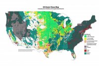
Here is a terrific map, compliments of Jeremy Perez. I obtained it from a friend, and don't know where he acquired it, but from what it says on there sharing it is okay for non-commercial purposes. Thanks, Jeremy! P.S. My one disagreement with the map is that I do believe that NW SD isn't quite as bad as this map depicts, despite what I said above. Otherwise, it is very very accurate for the most part. I have driven almost every road in The Alley. Hundreds of thousands of mile's worth.

StormChaseMap2016.JPG
 
I cut my teeth chasing in West Virginia and southwestern PA, so I always get a chuckle out of states like Missouri getting a bad rap. Bad terrain areas can be doable if you stick to major four-lane highways and interstates. Usually those are cleared out enough for at least intermittent good views. Once you venture onto a two-lane in those places, you're in an unbroken tree canopy.

Jeremy Perez has a thread on this subject with some good maps here:
http://stormtrack.org/community/threads/us-chase-map-project.28377/

View attachment 12151

Our Discussion so far....

FWIW, I've seen 8 tornadoes in that zone along the Mississippi River in MO and IL.
 
Last edited:
Bob, thanks for sharing the map. Looks like Dan posted a link to the original thread too.

It’s been informative to me to see some of the thoughts in this thread about other challenging areas, e.g., Southwest Iowa & north central Kansas. Road grid seems decent in those areas, but terrain and crummy road quality can quickly take a bite out of that. (The road network estimates in the map obviously don’t account for passibility of those roads—there was no way I could think of to account for that on a national scale.)

Hilliness of terrain would be a great item to include, but currently I don’t know how best to get data for that and incorporate it. One option I’ve wanted to add—and that seems within reach—is to plot in major rivers and where the primary crossings are. It’s in my queue to try that once I get a chance. In the meantime, I’ve been working my way up the unfinished states on west & east coast. Compared to the Plains, Rockies and much of the west, the major highway network on the east coast is pretty dense. So I can see what Dan’s saying that even sticking to the major thoroughfares, it seems like you could still have some decent options to position on storms.
 
Back
Top