• After witnessing the continued decrease of involvement in the SpotterNetwork staff in serving SN members with troubleshooting issues recently, I have unilaterally decided to terminate the relationship between SpotterNetwork's support and Stormtrack. I have witnessed multiple users unable to receive support weeks after initiating help threads on the forum. I find this lack of response from SpotterNetwork officials disappointing and a failure to hold up their end of the agreement that was made years ago, before I took over management of this site. In my opinion, having Stormtrack users sit and wait for so long to receive help on SpotterNetwork issues on the Stormtrack forums reflects poorly not only on SpotterNetwork, but on Stormtrack and (by association) me as well. Since the issue has not been satisfactorily addressed, I no longer wish for the Stormtrack forum to be associated with SpotterNetwork.

    I apologize to those who continue to have issues with the service and continue to see their issues left unaddressed. Please understand that the connection between ST and SN was put in place long before I had any say over it. But now that I am the "captain of this ship," it is within my right (nay, duty) to make adjustments as I see necessary. Ending this relationship is such an adjustment.

    For those who continue to need help, I recommend navigating a web browswer to SpotterNetwork's About page, and seeking the individuals listed on that page for all further inquiries about SpotterNetwork.

    From this moment forward, the SpotterNetwork sub-forum has been hidden/deleted and there will be no assurance that any SpotterNetwork issues brought up in any of Stormtrack's other sub-forums will be addressed. Do not rely on Stormtrack for help with SpotterNetwork issues.

    Sincerely, Jeff D.

Wakita cell - Just RFD?

I'm still a bit hazy on the details of this. The photos I grabbed were about quarter mile north of OK-11 on OK-11a (road to Wakita), I thought I was looking due west (perpendicular to the N-S highway I was on) and that was the MV in this photo that I took: http://www.whitedashes.com/mobile/IMG_0839_1068x712.jpg
It would be north of 11 already at that point right? I watched for a while before that photo, and I just thought it was always north of 11. Not sure though.

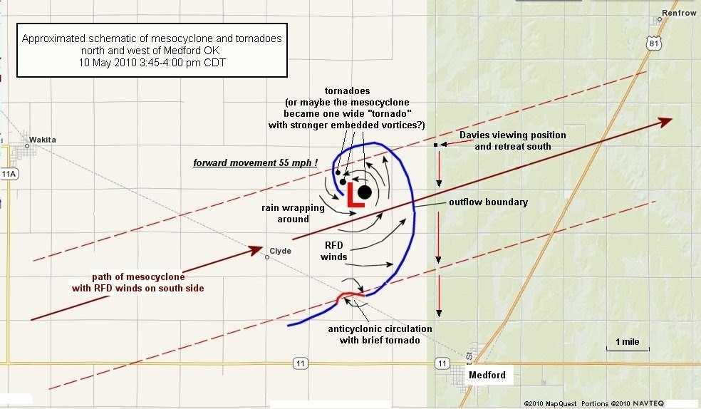
But all the accounts talk about the MV crossing 11...are they talking about mainline 11 or 11a? Even that video that was on TWC had it crossing the road (which I assume was 11?) Add on top of that the graphic from OUN showing the tracks, which doesn't even show it down before 11a on the graphic.

EDIT: The camera timestamp on that photo I linked is a few seconds after 3:40pm
 
Last edited by a moderator:
My camera timestamps show the storm Wedging out just east of HW81 north of Medford. It's still multivortex at 20:57, is rainwrapped by 20:58 and at 21:01 due north of MEdford, my images show the back half of the storm is fully condensed and it appears to have transitioned to a classic if rain wrapped wedge.

The heavy rain at the leading edge of the meso obscured my view between 20:58 and 21:01 so I can't be more precise than that, but I hope that helps.

If I remember correctly, the 20:58 Vance radar showed the mean wrapped up hook, and the 21:03 was the first radar scan to show the donut hole...
 
I haven't seen any videos with this part of the convoy at a distance where you can see clearly what is happening.
--Robert Hurkes

I was a few miles back from the video you posted. I hadn't planned on uploading it, but it may help a little on this discussion. It's only 480p and not great contrast, so I would imagine there may be some more detailed video between where I was and the video you posted. I was a little ways west of the 11A road to Wakita when the RFD punch in the video you posted hit. It was some amazing motion. This was sped up to 4x to see the motion even better, but also to negate a bit of camera bounce from my dash mount.

http://www.youtube.com/watch?v=q048JNGABDA
 
Davies' blog confirms everything I thought was going on, he is the man! This image explains everything.

051010medfordOKmeso_schematic_davies.jpg
 
The reason I've been curious about this is because I filmed a tornado that bounced around 6 miles East of Wakita Hwy, though this tornado was far from a Barrel or wedge, thus I'm not wondering if there wasn't a second circulation behind the main one...

Yeah I filmed that same deal as I went east and can say it was way way behind the main area by then. And way way nw of that I swear I was seeing a "spout" type deal on the ground, just a short condensed landspout type vortex stuck in one spot way way behind things.
 
Here is some video I shot of the tornado from Highway 81 just north of Medford, OK. To me it looks like it takes on a wedge form with multiple suction vortices rotating around. I am a novice when it comes to video (and chasing) so the video does not show everything I saw. I spent the first minute or so in awe just staring before I came to my senses and started taping. Shortly after I started taping it started becoming rain wrapped.

 
Last edited by a moderator:
http://www.youtube.com/watch?v=oNy-m3xLa0k

Robert - thanks for starting a very interesting thread.

I'm not sure how helpful this will be, but here's a bit of my video of the Wakita tornado just before and during its most pronounced multivortex stage. I shot this from just north of SR 11 on Trenton Road, about one mile east of the tree line. As others have noted, I too was struck (and alarmed) by the apparent southerly movement of the main circulation back across SR 11.
 
Back
Top