Tropical Conditions..

Joined
Aug 28, 2004
Messages
674
Location
Sylacauga, Alabama
The MJO has begun its shift back into a wet phase in the GoM/Caribbean/Western Atlantic basin and this signifies that conditions are possibly getting better for organized development as tropical waves develop and move westward.
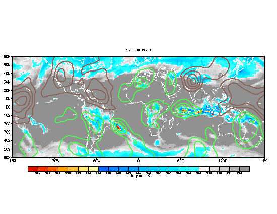
am_ir_monthly_1.gif


The ULL over the Gulf of Mexico has moved inland over Old Mexico and shear has relaxed a good 25-30kt over the Caribbean over the last 48-72 hours. The Bermuda HP is in favorable placement now for anything that rides into the Caribbean to become a possible Gulf storm. I believe that cane season is about to ramp up over the next week or so. I believe that the Gulf States and SE Coastline should keep a close eye on the developments over the next 2-3 weeks.
 
Cool, Brett-- I hope you're right. Although the 2006 season has been perfectly normal so far climatologically, of course 2005 completely warped my sense of reasonable expectations, and I find myself a little itchy for some action.

Of course, one only needs to think back to those really, really slow seasons in the early '80s (i.e., 1982, 1983) and compare those to 2005 to know that the range of possible seasons is enormous.
 
The MJO should help get the atlantic tropics stirred up I would say in about a week form now. Tropical depressions or storms in the deep tropics usually form about a week after the mjo moves over the region.
The ecmwf for several runs now have been showing a significant low emerging from west Africa during the 4 to 7 day time frame. The Bermuda/Azores high has been too strong in recent weeks which is normal for most of July into early August. During the next week or so this feature should loosen its grip somewhat and become more zonal. This change is needed so the African waves could survive the treck across the atlantic. If the high is too strong the flow will send the waves southwestward toward the direction of the equator and there they dissapate. Also the 200 mb flow is expected to improve quite a bit during the upcoming week, this is one of the characteristics of a positive mjo.
 
NHC has officially upgraded it to TD #2 at 11 A.M. EDT. A topic has been started in Chase Forecasts in regards to this new depression, so I think it would be prudent if further discussion of this system would take place in that thread so as to not irk the moderators. :rolleyes:
There is also an vaguely interesting tropical wave in the far eastern Atlantic. If the shear were to relax, it could become an organized tropical system over the next couple of days. TD #2 should become T.S. Beryl in about 12-24 hours;anyone else think there may be a possible T.D. #3/T.S. Chris east of the Windwards about three-five days from now?
 
Its official tropical storm Beryl was named at 2100Z today. Now lets see if the wave in the eastern atlantic will develop into something in a few days when it gets closer to 55W. 200mb flow should't be a problem.
The overall pattern in the atlantic basin is becoming more favorable for tropical cyclone formation. For one thing the SW monsoon over western Africa is becoming better developed in recent days and is forcast to be fairly well organized in the forseeable future. Also the 200mb flow over the tropical atlantic continues to become more conducive for tropical cyclone formation. The only thing as usual during this time of the season is the sst's (seasurface temperatures) in the eastern half of the tropical atlantic are only marginal for development.
 
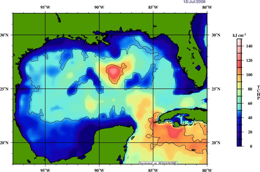
I've been reviewing the TCHP depiction for the Gulf of Mexico. It's pretty notable I think that it's well ahead of last year at the same date, and very similar to late August (Katrina).
2006199go.jpg
 
That anticyclonic eddy that was on the nose of the loop current (and now appears a little cut-off), is quite impressive with massive TCHP as David shows. With a large area of 60-70cm Dynamic Sea Heights and a max upwards of 120cm. There is also a very fast current between that and the cyclonic vortex just SE.

It's definately starting to look more favorable. With 15kts of Vertical Shear throughout much of the gulf/carribean (850-200hPa). The Gulf/Atlantic/Sub-tropical region all show at least .5C degree warm anomaly for this time of year. Several waves moving through the Atlantic now, with a pretty decent one coming out. Steering currents and placement of the Azores/Bermuda high doesn't look to favorable for a US landfall in the short-term but that could change soon. In the mean-time the coverage of the ridge is allowing more and more sun against the sea.
 
Back
Top