Spotter nets: how can chasers help?

In addition, our repeater changes its courtesy tones during various conditions. For example if a WW is in effect, it change from a simple "beep" to a Morse code "W" (dih-dah-dah). When a directed net is underway, it changes to a Morse code "N" (dah-dit). Periodic synthesized voice tail messages also announce either "weather watch" or "weather net." That's just one repeater in one place, but I thought you might find this practice of interest.

I did read about some repeaters doing that but I've never heard it. I'm pretty much a home chaser so I've basically only ever been on K-Link during storms. ;) K-link did start putting the "Skywarn Net Active" messages on in the past year or so but no Morse code courtesy beeps that I recall. Each repeater does have a different beep though, so over time you can learn who's talking through which tower.

And back to macro, since K-Link is pretty much a statewide system you do get people wandering in looking for ragchew while the net is up but NC simply tells them that the severe weather net is active and they are only taking storm reports and emergency traffic. I've never heard anyone be rude about it, nor has anyone been told that their report isn't welcome..
 
Last edited:
Re: " That's why our net controllers don't make any attempt to filter reports before they go to the WFO (except in the case of stuff we know the WFO doesn't care about, like lightning)."
Cha-ding! IMHO, that represents a policy that is in the best interests of public safety. And, to take it one step further, it also represents why "Closed Nets" are a problem on days when there is the potential for "emergency" situations. Refusing a spotter/mobile spotter/chaser's need to be on a Closed Net's frequency IS filtering and should never occur.


Dan, in the IWX CWA, spotters are not even vetted. If, for example, a person calls the WFO on the phone to make a report and identifies himself as a trained spotter, the WFO takes his word for it. They don't have time to look the person up. I don't even know who all on frequency has attended spotter training, except for the ones I remember seeing at the last session I attended. The WFO does not share its lists with our net controllers, so we also take a spotter's word for it. That's why our net controllers don't make any attempt to filter reports before they go to the WFO (except in the case of stuff we know the WFO doesn't care about, like lightning).

We let the WFO do the same thing with our reports that it does with telephone and social media reports: Compare the report to radar data and atmospheric conditions to decide if it's valid. Not being meteorologists, our net controllers lack the knowledge and skill to make such judgements.
 
If we get a database put together and allowed crowd sourced updates, we should be able to create a fairly accurate database quickly. I could also write a script to auto-generate a GRLevelx placefile so that we could have information beyond Kansas. Great work with the K-Link placefile BTW; I'll be using that as a start. Since I won't be chasing this season (unless an awesome setup occurs near my house on a Saturday), I'll have time to create this. I just need to know if you guys think it's worth my time to code this, and what information you feel would be important to include.

Hello Scott,

I will gladly assist as much as I can with this project.
Moving forward from this experience, I feel we can all contribute to this major task.

Daniel
 
Gentlemen,

Just for information about our link system, it overlaps somewhat with the SWIRA link, but we're more focused on the SW ok and the KSWO viewing area. There are four machines in the system:

442.525 +5 PL 123 Lawton, OK
442.200 +5 PL 123 Grandfield, OK
444.450 +5 PL 123 Cement, OK
443.300 +5 PL 123 Hedrick, OK (on top of Navajo Mtn.)

If the link system should fail, we have the machine on the Comanche Cty tower near the Lake:
444.075 +5 PL 123

Thanks Stephan.

Is it possible to provide GPS co-ordinates for these repeaters and the typical range (in miles) for them.
I'm going to attempt making my first placefile as a foundation of what's possible for the "National Repeater Placefile Project"

There.... We have a name for it now!
Daniel
 
Here it is!!!

www.hamchaser.com

Done
Skywarn Net Repeater database has been built. This database will store all net and repeater information. I have included every possible item I could think of based upon the comments here, and the information listed in other databases such as repeaterbook.com.
Website has been created, SSL enabled, and frameworks added.

To Do
Create Spotter database.
Create Users database (for login and permissions).
Create Entry page for each database (crowd sourced add / update suggestions).
Create Approval page for each database (so site admins can approve or reject suggestions).
Create View page for each database (along with search).
Write script to generate GRLevelX Placefiles.
Create Map using API to show locations of repeaters.
And lots more :)

How You Can Help
For right now, please let me know what items you would like to see in the Storm Chaser database. For Example: name, experience, home location, vehicle, phone number, call sign, reputation, spotternetwork id, stormtrack name, email address, etc.

Notes
For security reasons, I'm not going to provide details on the fields I created for the database, but rest assured everything discussed has been included (even Geo Location and Range of Repeater in miles)

I will update with more details as I make progress. I may also ask for help coding, inputting data, and administrative reviews of suggestions - but I'm not there yet.
 
Thanks Stephan.

Is it possible to provide GPS co-ordinates for these repeaters and the typical range (in miles) for them.
I'm going to attempt making my first placefile as a foundation of what's possible for the "National Repeater Placefile Project"

There.... We have a name for it now!
Daniel


Here's a quick and dirty place file for the LIRA stuff
 

Attachments

Is it possible to provide GPS co-ordinates for these repeaters and the typical range (in miles) for them.

Per Daniel's request, here is the data for the Fort Wayne, Indiana net mentioned previously.

Primary repeater, W9INX, 146.88 MHz, 41.0939694°, -085.1802028°, ~30 mile range for mobiles.
Back-up repeater (used if primary repeater fails), W9TE, 146.76 MHz, 41.1699222°, -085.0931389°, ~20 mile range for mobiles.
 
If we get a database put together and allowed crowd sourced updates, we should be able to create a fairly accurate database quickly. I could also write a script to auto-generate a GRLevelx placefile so that we could have information beyond Kansas. Great work with the K-Link placefile BTW; I'll be using that as a start. Since I won't be chasing this season (unless an awesome setup occurs near my house on a Saturday), I'll have time to create this. I just need to know if you guys think it's worth my time to code this, and what information you feel would be important to include.
Hey Scott, that would be a wonderful idea. Our sysadmin for our main repeater system K-Link (Justin, NV8Q) is actually the state admin of Kansas for Repeaterbook.com. He said the guy that runs the website is very active and open to new ideas. The biggest hurdle is knowing where the updates come from, so having some kind of an admin to vet the information before it is applied as gospel. Furthermore, collaboration or having a centralized database to pull information from. That's why I liked the RepeaterBook idea, because a lot of this is already done. Also, if a repeater listing hasn't received an update in 2 or 3+ years, the status changes to "Unknown" until someone applies an update. Either something like repeaterbook, or we could use something like Google Docs/Sheets, and have a script generate a placefile from there? I also have a google maps version: https://www.google.com/maps/@38.415...=!3m1!4b1!4m2!6m1!1sz1d3f_SQElbY.k5j0J6NWUdPk . I know it has the ability to export to KML/KMZ. The google map was just updated this week, but honestly it had been neglected since it's hasn't been as easy to edit.

Just throwing a few ideas out there. Let me know what you think.
 
I am reaching out to the Repeaterbook site owner to inquire about adding the ability to filter Skywarn repeaters in a multi-state search query. I'm sure he will be able to do this. Stay tuned.

Here is an example of filtering a single state:

https://www.repeaterbook.com/repeaters/feature_search.php?state_id=20&type=SKYWARN

The next thing I will ask for is the ability to generate a placefile with Skywarn repeaters that will import directly into GR3.
Please help us verify the Skywarn listings for accuracy.

Thanks,
Justin
NV8Q
 
Last edited:
I am reaching out to the Repeaterbook site owner to inquire about adding the ability to filter Skywarn repeaters in a multi-state search query. I'm sure he will be able to do this. Stay tuned.
The next thing I will ask for is the ability to generate a placefile with Skywarn repeaters that will import directly into GR3.
What YOU all can do to help is verify the Skywarn listings for accuracy.

Thanks,
Justin
NV8Q
Justin, thanks for doing that. Can you please see if they would also be willing to create an API so we can access the repeater information (geolocation, coverage, frequency, offset, tone, and website link)? If so, we could use hamchaser.com to keep track of net information, and repeaterbook.com to keep track of repeater information. That would save a lot of work and no need to duplicate the awesomeness of repeaterbook.

Sent from my SM-G920V using Stormtrack mobile app
 
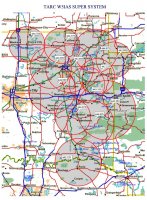
Here is a link to the Northeast Oklahoma Skywarn link system. They run severe weather nets and accept all check-ins. These repeaters link into the 443.850 machine in Tulsa. NWSFO Tulsa monitors the 443.85.

Additionally we run a more local net on 147.09+ pl88.5 for Tulsa/ Rogers/Wagoner counties. Feel free to jump in on that frequency as well. We relay direct to NWSFO Tulsa.
 

Attachments

  • W5IAS_repeaters.jpg
    W5IAS_repeaters.jpg
    190.3 KB · Views: 99
I am reaching out to the Repeaterbook site owner to inquire about adding the ability to filter Skywarn repeaters in a multi-state search query. I'm sure he will be able to do this. Stay tuned.

Here is an example of filtering a single state:

https://www.repeaterbook.com/repeaters/feature_search.php?state_id=20&type=SKYWARN

The next thing I will ask for is the ability to generate a placefile with Skywarn repeaters that will import directly into GR3.
Please help us verify the Skywarn listings for accuracy.

Thanks,
Justin
NV8Q

Justin, have you heard back from Repeaterbook yet? Thanks to the contributions of many, the Skywarn Net Database project (www.hamchaser.com) is quickly becoming a reality. We would love to utilize the vast resources of Repeaterbook for repeater information rather than rely upon this community to recreate all of the hard work that has already been done building the repeater database.

Here's What We Are Working On
  • The Skywarn Net Database project will map out all repeaters used by a net link (K-Link, etc), and color code the repeaters so that you know whether or not the repeater you are switching to has different rules from the repeater you are currently on.
  • You will also be able to view the net rules and detailed net information for any given repeater. You'll know who the net control operator is, and what rules to follow, before you transmit.
  • We are also adding dynamic placefile creation that will generate a new placefile upon request using the information in the database.
  • If a chaser does not use GRLevelX placefiles, then a mobile map can be displayed instead that will show nearby repeaters based upon your GPS location from your phone or computer (or general location if GPS is turned off).
  • We MIGHT add text to speech so that you can listen to the net rules while driving, rather than dangerously reading them while trying to keep your eyes on the road. If we do add this, it might also include the ability to give voice instructions for navigating the web site.
 
Scott, thank you for your excellent work on this!

I also wanted to throw out the question of what type of equipment would be a good fit for a chaser wanting to report? Namely, what would be the bare minimum one would have to spend to be suitably equipped? Cost is going to be a concern for many, so I'm hoping there is a setup that is both affordable and capable that minimizes the barrier to entry.
For an absolute bare minimum, a Baofeng UV-5R (or similar) handheld transceiver is available for $50 or less on Amazon and elsewhere. It's a bare minimum whose signal won't be strong enough to reach some repeaters from rural areas. Next step is to connect the handheld to an external (e.g. magnetic mount) antenna, which will extend its range by several miles. Best option is a mobile radio (25 watts or more) connected to an external antenna. An example is the TYT-TH-9000D, $120 on Amazon.
 
Namely, what would be the bare minimum one would have to spend to be suitably equipped?

Most Skywarn groups in the DFW area have a requirement similar to this: "Mobile users are expected to have a 2M (144MHz to 148MHz) radio with a minimum output of 25w, and a 5/8 wave antenna, on a good ground plane. Fixed Station users should plan on having similar hardware. Handy-Talkies (except with an amplifier) are generally not sufficient, for most nets."

You can get 2M mobile radios for as low as $130 and a 5/8 wave mag mount antenna for around $30 online (and lower at ham fests). Even a 1/4 wave length antenna would work, and you could get them as low as $15. So for as little as $150, you could get going. Spending just a little more will get you better stuff, but a minimum setup will get you on the air.
 
Back
Top