• While Stormtrack has discontinued its hosting of SpotterNetwork support on the forums, keep in mind that support for SpotterNetwork issues is available by emailing [email protected].

Southwestern US Monsoon 2025

Image.jpg
_________________________________________________________________________________________________________________________
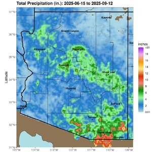
With little more than a couple weeks left in the official season, this updated map shows the overall trend this year quite well (U of A.)
North of Flagstaff, east of Prescott, and mainly southeast AZ around Sierra Vista had some consistent activity shown by warm colors.
 
Pretty much a good representation of the northern extent of RH this year, along with few (if any) major easterly waves. And most the RH was the result of post-storm surges working north from Mexico as opposed to large scale circulation from the usual monsoon ridge placement. The only good thing for chasers was the occasional line of storms from surge reloads and the lack of dust bed-wetting (lol), which lead to a lot of big dust storms.
 
It took til September to finally get anything decent lightning-show wize out of 'monsoon season'...

There were some storms on the 10th (not sure they were even monsoon driven though, given how far north & east they were).

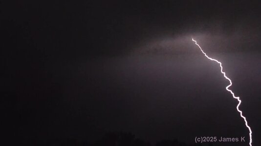
On the 13th there was some monsoon moisture & a couple evening/night storms fired up. Not big lightning producers, but were at a decent viewing distance & gave some nice strikes. Certainly worth sitting out & watching
 
And on the 16th, that was certainly a good evening! A very nice way to close out storm season. Sometimes those little waves of monsoon moisture do good :)
I originally went out to watch when there was one cell on radar ~70 miles to the southwest (wanted to see if I could see it since it was over the place where me & my brother go camping)
And yep, I could see flashes up there!...then while I was out there more cells started forming much closer to me.
They eventually grew together into a small squall-line/QLCS....and I basically got to sit there & watch it build.
(love when that happens, only seen it twice now).

There was a point I had to get both camcorders out since there was multiple little cells & lightning coming from different directions.
While not a rapid-fire lightning storm, some of the cells gave a nice show dropping CG's & in-cloud strikes at fairly close range. I sat & watched/videoed basically til the line was right on me. .lol.
At the point when I could hear the heavy-ish rain approaching I closed up the cameras...it was time to head in from the roof...so yep got in my maximum watch-time! .lol.
One of those rare nights. Had to wait all summer for it, and was well worth sitting out watching from its beginnings...
 

Attachments

  • 9-16_n3-h.jpg
    9-16_n3-h.jpg
    72.9 KB · Views: 1
Then there were some little storms again on evening/night of the 17th.. which I ofcourse went out to watch as well.
And last week (Sep 23/23), no lightning but a nice rain - got 1" total - which is really good for here.
 
Image.jpg
___________________________________________________________________________________________________________________________
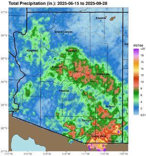
Did anyone notice the western trough, upper low, and subtropical moisture in AZ over the weekend? Severe weather, hail, flash floods?
In addition to the central portions of the state getting in on the act...
Phoenix picked up more than 1.6 inches of rain on September 26th to make that their rainiest day in ~ 7 years.
Looking back at the season, PHX Sky Harbor got 2.8" in the bucket to best their normal of 2.4", thanks largely to those "last minute" storms.
Yuma saw twice their normal, 2.2 compared to 1.1 inches, but Tucson registered only ~ half of average, receiving merely 2.8" at their station.
Flagstaff got 5.1" and they average 7.7". A lot depends too on if you're on the wetter windward side of the mountains or the drier, lee side.
If you enjoyed this post, please hit like. ;)
 
William Monfredo said:
Did anyone notice the western trough, upper low, and subtropical moisture in AZ over the weekend? Severe weather, hail, flash floods?
Actually, yep I did... though I'll admit I was looking to see if anything was headed my way. (The remains on that system was yesterday afternoon's round of thundershowers (which if video turns out I shoulda captured a few nice CG's))

I saw the storm that caused the flooding at their airport on radar (as well as others), then heard about it on the news the next day.

--
Also curious where did you get the rainfall totals graphics? I want to see if there's something like that for CO
 
James and/or William, if you find something like that for Colorado, please post here as I would like to see it. Overall it was a pretty lousy monsoon in southwest Colorado, but at least we did a little better in September. At my gauge in Pagosa Springs, our total September rainfall stands at 2.24". That puts us a few tenths above average, a rarity for here for any month in 2025. And we possibly could still get a little more this afternoon.
 
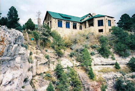
The big story of this year's monsoon...the lightning-spawned fire at the North Rim of Grand Canyon in July that burned ~ half the infrastructure.
It shut down their season, but select areas opened for public access October 1. North Rim gets about a tenth of the visitation of the South Rim.
2461-R1-07-18_008.jpg
My shot above shows the Lodge before destruction.
It also burned down and was rebuilt in the 1930s.
1.jpg
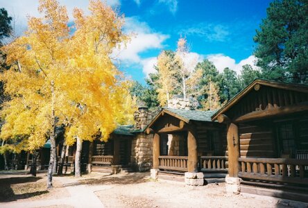
A before photo of mine shows the visitor cabins, but in many instances, all that remains now are the stone chimneys.
The peaceful North Rim of Grand Canyon will be fully open this May, but as a limited-services experience for travelers.
The destructive "Dragon Bravo" fire in northern AZ began with a Fourth of July thunderstorm and continued for months.
 
Back
Top