• While Stormtrack has discontinued its hosting of SpotterNetwork support on the forums, keep in mind that support for SpotterNetwork issues is available by emailing [email protected].

Southerly flow in the jet stream

Joined
Apr 24, 2014
Messages
97
Location
Peoria Illinois
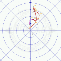
I was wondering if this type of flow pattern aloft would cause issues with the hodographs, potentially contributing to a vbv profile? If not, what generally are the causes for a vbv profile?

It seems like the flow aloft this past weekend had a bit more of a southerly element. Good turning in the low levels, but then forced to back in the upper levels?

If you do have this type of flow aloft, rather than out of the SW, do you need your winds to back even more in the low levels to compensate?

Forecast hodo taken near Salina
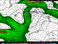
2015-05-12 10-04-30_COD Meteorology -- Numerical Model Data.png

2015-05-12 10-16-01_COD Meteorology -- Forecast Soundings.png
 
Last edited:
One important thing to look for is how the mid and upper flow is aligned against the initiating boundary. Lets's say (for arguments sake only) there was a N-S orientated dry line in central KS at this moment. Any storm which forms will have all its precip blown away to the north, potentially into other developing storms, leading to widespread seeding, excessive cold pool generation, and eventually a linear mess of storms. The more ideal scenario is strong SW or WSW flow in the mid-upper levels against a N-S dry line. The actual idea of veer-back, veer-back-veer, etc, has to be looked at in the wider context of initiation, propagation, etc, rather than just being looked at in isolation.
 
I can't honestly say I know what causes a veer-back profile other than shaky height structure in the mid-levels. Seems like a noise issue rather than something on the synoptic scale that's messed up. But that's just speculation.
 
Back
Top