Silver Lining Tours vans rolled in Kansas

Status
Not open for further replies.
This would be a far more entertaining thread if the tour involved was one that's not held in high regard. It wouldn't change a single fact about what happened, but reaction would be must-read stuff.

It would take the miracle of all miracles for me to ever be hit by a tornado while chasing, because I control my situation out there through my decision making. To be impacted directly by a tornado- satellite or main - requires a very deliberate set of decisions that set up the circumstance within which being struck by a tornado is possible. I sure hope if it ever happens to me, the "community" is as forgiving as it has been with others. However, I somehow doubt that would be the case.

There are some chasers who can do no wrong... Usually after an accident you reflect and consider what should be done differently in the future. All I've read is it was an accident, un-forseeable. As mentioned it is curious how the 'best' chasers out there keep getting hit by tornadoes. Yet the ones we squabble about are those a few miles out. I really hope someone like Skip will do an analysis of this accident.
 
My understanding is that the El Reno impact on both Tim Samaras and team, as well as on The Weather Channel crew, were the result of satellite tornados. With TWC I am pretty sure it was definitely a satellite. In the Samaras tragedy, I guess it could be a bit ambiguous, it was a satellite tornado that was actually within the outside circumference of the main circulation, not displaced from it as in the SL case.

Both Twistex and TWC were impacted by subvorts inside the main ~ 2 mile wide circulation. Both were actually quite close to the center of the broad parent circulation at the time of impact.
 
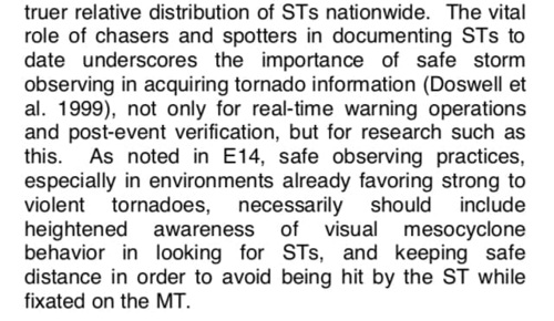
There is a more recent academic publication on satellite tornadoes (STs) that Roger Edwards, a co-author of the paper and employee of the SPC, shared in another group. It's worth a read given that this is a topic a lot of chasers, including myself, probably fail to consider on days where the environment may particularly favor strong to violent tornadoes.

ENVIRONMENTS OF SUPERCELLULAR SATELLITE TORNADOES

18503
 
Last edited:
Their statement on Facebook said they were hit by a satellite 2 miles southeast of the main circulation. On NWS Damage Assessment Toolkit the third DI along the path has a photo of the house with destroyed barn along with their van in the foreground. Thoughts?

1175157
 
Via Facebook:

As many of you are aware, we had a very unfortunate incident happen last night. While chasing the Lawrence, KS tornadic supercell, we were hit with a rain wrapped satellite tornado 2 miles southeast of the parent circulation.


We were hit by a rain wrapped satellite tornado that was not very close to the main mesocyclone.

There was nothing we could have done differently, as we were in fine position

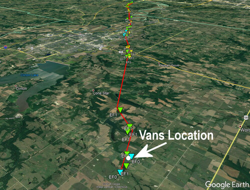
A van is visible in NWS Topeka's damage photos from the survey. Here's a map of the location:

18507

Not drawing any conclusions here, but either NWS Topeka or the above accounts are in error, misunderstanding something, or incomplete in information.

The damage survey sure makes it look like they were hit by the main tornado, but I've seen significant errors in surveys before. But even so, the impact location is in line with the latter part of the track, so I'm struggling to come up with a scenario that jives with the above accounts.

:\

I'm not pointing fingers or trying to tear people down. People I like and consider friends are involved here. I worked hard on the El Reno Survey with lots of other folks because I didn't want to see any more friends killed by tornadoes, so that we could learn and better ourselves.
 
Based on that information, it isn't inconceivable that there could have been a satellite circulation that occurred coincident with, or just before, the main tornado spinup, then merged with it. The dogleg at the start of the path at least leaves that possibility open.

The long gap in DIs immediately after the dogleg also presents the possibilty that that initial track segment was a satellite, with the main circulation producing the DIs further downstream.

Aerial photos might be able to shed some light on those questions, as I understand damage to crops in fields are not DIs that would be recorded in this data.
 
Last edited:
Based on that information, it isn't inconceivable that there could have been a satellite circulation that occurred coincident with, or just before, the main tornado spinup, then merged with it. The dogleg at the start of the path at least leaves that possibility open.

The long gap in DIs immediately after the dogleg also presents the possibilty that that initial track segment was a satellite, with the main circulation producing the DIs further downstream.

Totally. It's entirely possible the survey is in error and that a satellite has been lumped in with the EF4. This exact error happened on the Pilger/Wakefield damage survey of June 16, 2014.

Satellite or not, I'm still struggling to see how they could have been comfortably south of a tornado producing region by a span of miles. They'd still be directly in line with the part of the storm that produced the EF4. The best case scenario I can come up with is they were watching a separate (old and occluded perhaps) meso to the northwest, a (satellite) tornado came out of flanking updraft base over them, then the storm pivoted or a new mesocyclone cycle started to the south and downstream of them afterwards, taking on a similar track of the satellite.

It could happen to anybody.

I don't know what happened here, and these storms are extremely complex. I was on the Luray to Tipton supercell and it was producing a myriad of tornadoes in complex configurations.

But we need to stop saying "it could happen to anybody." There are people out there that this will never happen to. They simply don't position themselves under or near parts of the storm that could possibly produce a tornado. I'm not one of those people. I've been impacted by weak circulations a couple of times while positioning under the horseshoe. I elect to take on that risk with my chase partner's consent. Is it ok for a tour to do the same? I don't know.

It's not an innocent accident to be hit by a "satellite". When you're under the base of a supercell, you're taking on the risk of being impacted by a tornado. Everyone needs to acknowledge that and take responsibility for their actions because lives are on the line.
 
But we need to stop saying "it could happen to anybody." There are people out there that this will never happen to. They simply don't position themselves under or near parts of the storm that could possibly produce a tornado. I'm not one of those people. I've been impacted by weak circulations a couple of times while positioning under the horseshoe. I elect to take on that risk with my chase partner's consent. Is it ok for a tour to do the same? I don't know.

It absolutely can happen to anybody, but I agree most chasers won't be in that position. But you can't say that saying "it could happen to anybody" is wrong.
 
I don't know these people and I don't know what their intentions were at the time, but I have to wonder why a tour group was punching the core of a near zero visibility HP supercell with a history of producing rain wrapped funnels earlier in its life cycle.

Liability waivers? Unless they are properly worded AND comply with Kansas state law (since the accident happened here) they're worthless. Even then, a waiver doesn't prevent a lawsuit nor keep the operator from having to shell out thousands of dollars in legal fees to gain a dismissal.
 
There are two versions of this incident, the one we're all getting publicly, and the one behind closed doors. But I find it odd that the "community" seems to have developed a habit of turning the other cheek on these incidents rather than scorning those involved. In the past, getting hit by a tornado was considered the Ultimate Sin, and anyone who even came close was burned at the stake. And in all the damage control PR releases, not one word about "we made a mistake" or anything like that. It's being spun as they were innocent victims, but that only applies to the tour guests.

So which is it? A simple double standard with which free passes are reserved exclusively for the famous/popular, or are people so desensitized to these accidents they simply no longer care or are angered by irresponsibility?
 
Not drawing any conclusions here, but either NWS Topeka or the above accounts are in error, misunderstanding something, or incomplete in information.

The damage survey sure makes it look like they were hit by the main tornado, but I've seen significant errors in surveys before. But even so, the impact location is in line with the latter part of the track, so I'm struggling to come up with a scenario that jives with the above accounts.

:\

I'm not pointing fingers or trying to tear people down. People I like and consider friends are involved here. I worked hard on the El Reno Survey with lots of other folks because I didn't want to see any more friends killed by tornadoes, so that we could learn and better ourselves.

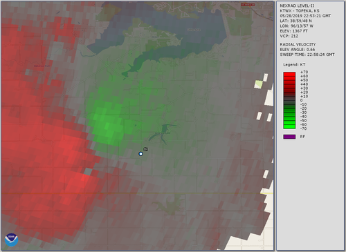
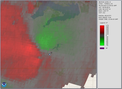
So, seeing the preliminary track that Skip showed, I decided to go pull the data from the nearest radar (TWX 88D). The radar was ~40 miles from the start of the preliminary track location, and the radar beam on the lowest elevation angle was centered ~1.2 km AGL. I have no information about the tilt of any tornadoes from this height down to the ground. It's not unusual for the circulation associated with tornadoes to be tilted (sometimes by 45 degrees or more). What follow is a very quick look at data from the lowest elevation angle only. It's mainly done out of curiosity about the start of the tornado. At this point, this might as well go into an event discussion thread.

It looks like there was a small circulation of some sort before the start of the tornado track by several miles around ~2255 UTC.
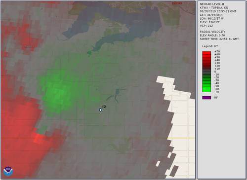
20190528_225531.png

It looks like this circulation moved generally ENE:
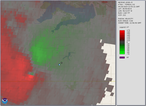
20190528_225650.png
20190528_225824.png20190528_225941.png

A larger area of convergent, cyclonic rotation was located to its north during this time. Unfortunately, between 2300 and 2303 UTC, it's not entirely clear how this situation evolved. By 2303 UTC, there's a small indication of the earlier circulation, and the larger-scale circulation remains centered generally a mile north. However, by 2304:40 UTC, indication of the original, smaller circulation is again apparent ~1 mi to the south of the larger circulation.
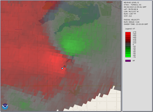
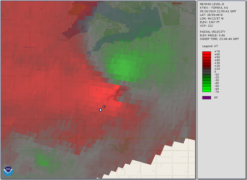
20190528_230309.png
20190528_230444.png

After this scan, the velocities begin to intensify more significantly, or at least those that are associated with the parent circulation do. Note that there isn't particularly significant gate-to-gate shear yet, at least nothing like what we see later.
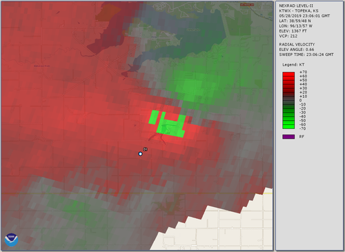
20190528_230624.png

So, did the original, small vortex that moved ENEward from ~2255 to 2305 on onward go on to become the "Lawrence" tornado as the preliminary survey indicates (perhaps when it became better situated within the broader area of convergent, cyclonic rotation), or was it a separate tornado? These data, by themselves, cannot answer that question; a more thorough analysis is needed.

*This is an extremely cursory analysis of the TWX data, and it is far from conclusive at this time.*
Edit: What little speculation I had wasn't needed and has been removed.
 
Last edited:
I think it's risky to speculate as to what occurred before the entire story is known. I would defend any chaser including "you know who" until the facts are known. Past issues do not always relate to the current situation unless you need to establish a history of negligence. I have assisted at multiple accidents as an EMT where it seemed quite obvious what occurred, only to discover during a witness and reconstruction expert deposition that something entirely different lead to an accident. We don't know, for example, if they encountered a road block, giant hail or chaser convergence that required a last minute course change. So everything is speculation until the entire story is known. Also, every comment on this site WILL be reviewed by legal researchers if it comes to that, as they searched every possible social media and discussion group following TWC's two disasters.
 
Jeff Snyder was on to something with the radar images in his post above.

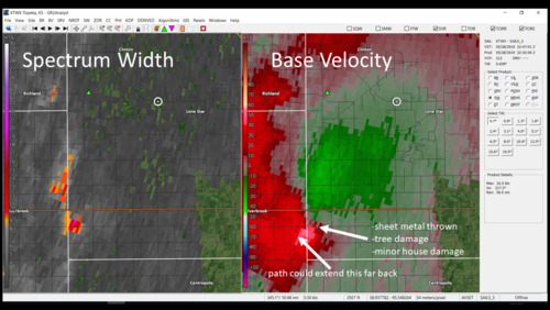
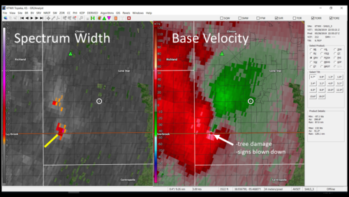
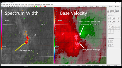
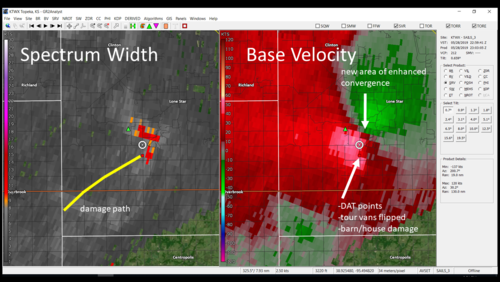
I surveyed the area today. I am not passing judgement or trying to get anyone in trouble. Mistakes happen. However, I felt compelled to find out what happened from a scientific perspective. This is a case that all chasers can learn from, and perhaps it could result in more caution being exercised.

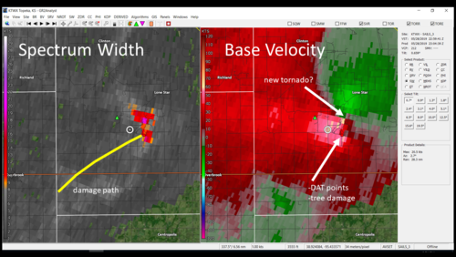
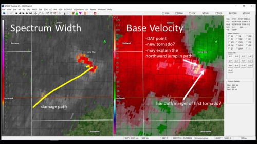
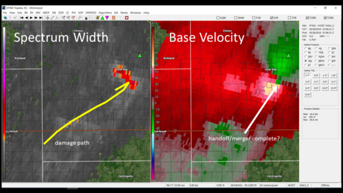
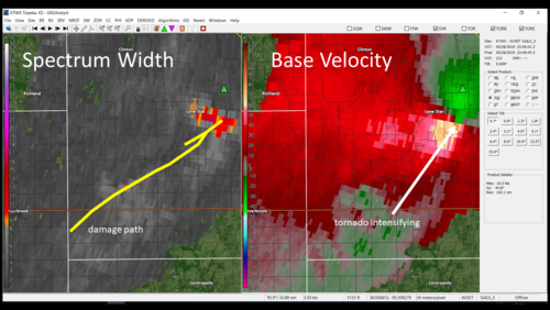
The following images indicate what I think occurred. It is likely that a wall cloud was visible to the northwest of the tour group. However, it seems that a tornado (probably not visible) was already in progress to their southwest which went on to merge with the circulation to the north. The messy nature and volatile evolution of this storm was something probably more common to Dixie Alley. We see lots of small tornado signatures like the one observed in this case.

Slide2.PNGSlide3.PNGSlide4.PNGSlide5.PNGSlide6.PNGSlide7.PNGSlide8.PNGSlide9.PNG
 
The radar images seem to depict a Hesston-Goessel style handoff/merger rather than a satellite (old tornado is pulled into the meso of the new one). In their position, you would normally expect to be in RFD with westerly winds. Is anyone aware of papers done on surface wind fields during these types of handoffs? Seems like it would be very complex and confusing for a chaser especially without any visual reference. We've seen a couple examples of these in recent years (Pilger-Wakefield 2014 and Dodge City 2016).

In any case, the data appears to be consistent with their account of the event. I personally don't see a reason to doubt it yet, given this and their reputation/track record.
 
Status
Not open for further replies.
Back
Top