Rolling Fork Tornado

Joined
May 19, 2020
Messages
108
Location
Eastern KS
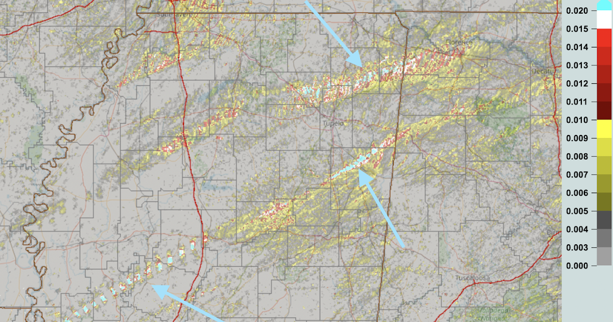
Looks like a large violent EF3+ tornado got a direct hit on Rolling Fork MS. I was on another feed and they said a chaser was hit and cut up pretty bad. Saw trees mostly stripped of all but the trunk and debarked in one picture. Chaser said people are screaming for help from the rubble and they need help.
FOX Weather on Twitter: "This is our first look at Rolling Fork, MS after a confirmed large tornado tore through the town. 🔴 Watch FOX Weather live: https://t.co/B2dBlpLqhR https://t.co/vDvnqsEe7M" / Twitter

South side of Rolling Fork hit hard by tornado - Vicksburg Daily News (vicksburgnews.com)

Edit: It sounds like Silver City also took a direct hit. Brett Adair reporting houses swept away.
 
I believe that same supercell put down another strong tornado that tracked very near Smithville. The radar presentation is the strongest I remember seeing since Mayfield. Daylight is gonna bring some horrific images I'm afraid.
 
I was watching things unfold earlier in the event, but was out with friends when the Rolling Fork tornado occurred. I checked Radar Scope a few times on my phone, and saw tornado warnings but they were all radar-indicated when I happened to look at them. Looked like they were mesos embedded in a line. Earlier, I had taken screen grabs of the radar images posted here. This storm was southeast of Jackson, whereas Rolling Fork is northwest of Jackson. According to SPC storm report times, the Rolling Fork hit occurred about 90 minutes after these radar images, so I assume the Rolling Fork supercell must have been one of the embedded / semi-discrete cells in the line that followed the open warm sector storm pictured here? I don’t think the storm pictured here went on to do much, which is surprising. But I could be wrong, I just wasn’t able to follow things too closely.

As an aside, I know it’s just anecdotal, but the Yazoo City area seems to be affected by every single big event that affects Mississippi…

D21A3FA0-D83A-46FA-A53B-EF84FF559047.jpeg5A045AD0-3C4A-42A6-9B04-A8FEAC4B94B5.jpegA0DB7626-1F17-490D-B13E-D24BF9454D17.jpeg
 
Screenshot_20230325-003221_RadarScope.jpg@JamesCaruso - I believe it was an embedded cell north of the one you have pictured. I'm pretty sure that cell covered 200ish miles hitting Rolling Fork, Silver City, and Armory. It looked to be weakening as it tracked near/over Smithville. The CC drop indicated quite a bit of debris in the FFD.
 
Now that we're seeing footage illuminated by daylight, I've seen nothing so far to indicate even a borderline EF5. I'm guessing EF4, but as someone who used to work construction, there are far too many parts and pieces of buildings that I can still recognize. I've seen several where the frame boards are still intact, just scattered. So I would pump the brakes at this point on any EF5 talk, regardless of what the radar presentation looked like.
 
[@JamesCaruso - I believe it was an embedded cell north of the one you have pictured. I'm pretty sure that cell covered 200ish miles hitting Rolling Fork, Silver City, and Armory. It looked to be weakening as it tracked near/over Smithville. The CC drop indicated quite a bit of debris in the FFD.
[/QUOTE]

I think it was 90 minutes later than the one I posted though… My radar image was around 7:30pm EDT, while time stamp on SPC is around 01z which would be around 9pm EDT.
 
rollingfork_fig1.png

Quite surprised by the Rolling Fork tornado. It managed to fold over the velocities beyond the nyquist using the Four-DD velocity dealiasing algorithm. The quick expulsion of debris after hitting the town was almost like no other I'd seen on radar.
 
Given that Fox News is saying there was "no warning," and for other reasons, I have written a report on last night's Mississippi tornadoes.

 
@JamesCaruso - You are correct James, I misread your post... sorry bout that. The cell I was referencing was a few hours behind the one you screen grabbed, but displaced further north in it's track, as you had mentioned.

I also agree with Jason and Drew... EF4 at most. I'm far from an expert with the rating system, barely knowledgeable in fact, lol... but I think it'll take top end damage on a governmental institution to achieve an EF5 based on trends over the last decade. The radar was really impressive at times, but quick scans of the images I saw this morning seem to fit an EF4.
 
The pictures that I've seen throughout the day haven't changed my opinion yet. There's still just too much debris that is recognizable as specific components (framing boards, bricks, etc). Without being on the ground to see it, I've not seen a lot of evidence of proper anchoring or hurricane straps (which I don't believe are required in that part of Mississippi, much like Tennessee). Fortunately I've not seen a lot of CMU foundations so far, but given how large some of the building materials are in the debris piles, I tend to lean somewhere around 170-180. I think it will ultimately be an EF4, but I've not seen anything to indicate high end. That opinion, of course, is still subject to change as more pictures filter out.

I do think you can get an EF5 DI with a home that's properly anchored with hurricane straps, etc, that isn't compromised by flying debris (which fortunately that is fairly easy to spot in most cases), but the chances of finding something of that nature in that part of the country where no shortcuts were taken is difficult at best. Even with government buildings, I've seen too many corners cut over the years with the big contractors that get the bulk of .gov contracts. After Mayfield, when everyone was talking about the UK annex, I asked who built it knowing how the Lexington based firms are, and sure enough, it was one of the ones that were known to cut corners when I was in the biz still.

I will add the caveat that I'm not an engineer, but I did a good deal of residential construction out of high school, and can very quickly recognize good and poor construction techniques. Also, codes in that part of the country have not changed enough for me to not be knowledgeable on building codes there.
 
I want to know whether or not that crumped water tower was full—I’m thinking not.
 
I want to know whether or not that crumped water tower was full—I’m thinking not.

The first thing I looked for was puddles or any other sign of water from the tower.

In the 1955 Udall Tornado, the toppled water tower was full and people -- who dashed into their basements at the last second -- drowned.
 
I'm impressed that a number of chasers, including Reed Timmer transported some of the injured to regional hospitals. Ryan Hall raised over 100k for relief efforts. This is all good. I did hear of some chasers walking though the rubble live, not paying much attention to victims or helping. Still a lot of chasers trying to zero-meter nighttime, fast-moving wedges and bragging about it. I'm shocked no chasers were killed. Sadly, it's only a matter of time. Everyone seems to forget about satellite tornadoes and rapid, deviant vortex motion with these violent set-ups.
 
How wide was the tornado? It’s varied from 1-2 miles wide… the debris signature was 2 miles on my radar.
 
Given that Fox News is saying there was "no warning," and for other reasons, I have written a report on last night's Mississippi tornadoes.


SPC Day 3 on Wed 3/22 was already making it apparent this would be a high-end event, and the area was outlooked at least as early as the Day 4 on Tuesday (maybe earlier, I haven‘t gone back to look…)
 
Can anyone answer a question for me? Are these rumors true or not that a chaser whom I will not name at the moment, is claiming that he has video of the wedge with a van full of people with their headlights on, going around the outer edge? I have seen it, but doubt it. If this were true, it would be international news, and would have been mentioned in every outlet there is. It could be anything with a light on it. I am guessing it is a mistake or hoax. If real, has law enforcement confirmed this?
 
I watched multiple YouTube videos on this storm, and on the ones with the worst damage, yeah I'd agree it looked EF-4 range, It just didn't have such complete and total destruction of the building remains (or even trees) that I'd say EF-5 .. Of some of those houses that were 'slabbed' I question how well they were anchored simply no way you can tell from a drone view.
------------
A couple radar grabs from when it was near Amory, certainly looks pretty intense at this point .. I've seen/heard nothing about whether the town was hit or not (I'm assuming that's a good thing, meaning it was missed)
 

Attachments

  • amoy_v.jpg
    amoy_v.jpg
    430.5 KB · Views: 0
  • amoy_cc.jpg
    amoy_cc.jpg
    546 KB · Views: 1
Also when looking at radar velocity, I was getting this in super-res for awhile, but it would look normal at standard res.
I'm assuming its just a bug in wX?? Or maybe just where it was located in relation to the radar site?

Oh and that couplet looks pretty close to Anguilla, but maybe passed just to the south missing the town? (like Amory I haven't seen/heard anything about it)?
 

Attachments

  • anguilla_v.jpg
    anguilla_v.jpg
    337 KB · Views: 1
@Rick Schmidt - From the videos I've seen, I'm leaning towards the light being a drone. It stays lofted much longer during the second pass then I'd imagine a vehicle would. As you said, if it was a vehicle, I'd imagine news of it would be trickling out by now. Hard to say with what I've seen thus far.

@James K - I use RadarScope for radar and wX for just about everything else, so I can't confirm a bug there. I did notice one of the radars (KGWX?) seemed to be missing a few scans in SRV where new scans appeared to be spaced by 10 mins or so, over the course of 40ish mins. I was at a "required social gathering, lol" so I didn't have the ability to monitor the unfolding situation as closely as I would've liked.
 
Back
Top