Ridgecrest, California earthquake sequence (Searles Valley) - July 2019

A few more shots:

Fresh scarp along fault surface rupture near Ridgecrest with about 18 inches of vertical displacement, about 2 feet or so horizontal:
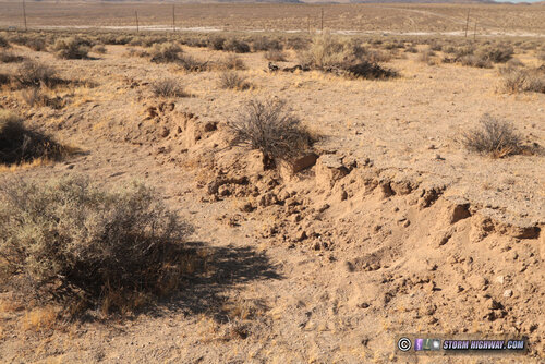
july1617g.jpg

Another dirt road offset by the fault surface rupture near Trona Pinnacles:
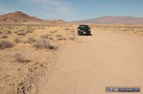
july1617f.jpg

Drone shot of the surface rupture trace going through the fence (posted earlier):
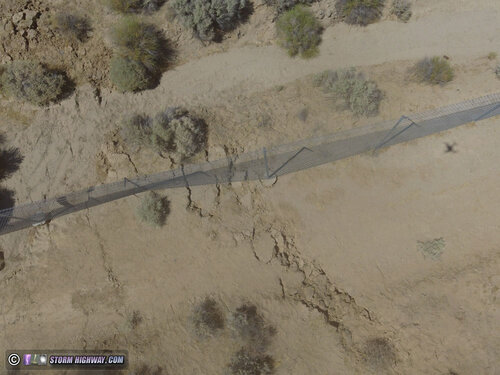
july1617k.jpg

So far, the M4.5 is the only earthquake I've felt. I've been in a dozen or so M3s (some very close) and many more 2s but have not felt any of them.
 
Last edited:
Nice pic's & descriptions Dan Robinson!

Those offsets & cracks in the ground would be fascinating to see up close in person...but I wouldn't to be near that place. The thought of the ground moving below me is downright scary (not to mention things falling/buildings collapsing/etc)

Now being in a chopper above the open desert at just the right time/place, when that thing let loose, watching cracks form & the shift happen...that would be awesome!
 
It would be safe to be standing outside right on top of the fault when it goes. You could stand straddling the fault, providing you could even remain standing during the shaking (probably better to sit down on it!). The only risk there would be falling over during the shaking and maybe breathing in the dust kicked up from the ground. The main dangers during quakes are indoors where things can collapse and objects can fall on you. Out in the open like here, it would be an amusement park ride. The holy grail would be to capture the surface rupture as it happened, so far that has only occurred once during a quake in Hualien, Taiwan:


The Hualien quake was a thrust event where movement was more vertical. In SoCal, most of the major faults are transform (strike-slip) where the bulk of movement is horizontal.

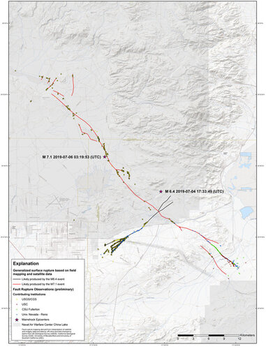
BTW, here is the USGS map of surface ruptures from the M6.4 and M7.1 events. I have not yet made it to the M6.4 trace since there has been plenty to see with the much more impressive M7.1 trace.

RidgecrestSurface Ruptures.jpg
 
Had a M4.6 this evening that happened while I was driving back to the hotel (grrrr!) so I didn't feel it. My hotel room cameras caught it, but the shaking was much lighter than yesterday's M4.5.

Joe, that looks like a landslide fissure, where one side is pulling away. Big landslides can happen during earthquakes, but along the faults that produce them, the rocks don't pull apart, they are simply sliding past each other (staying in contact before and after).

Here is a USGS faq on that:
Can the ground open up during an earthquake?
 
I wonder if the movement and the shaking felt on each side would be similar. My guess would be that relative to the earth one side would move more than the other, but that may not be the case. Very interesting stuff.
 
@Dan Robinson:
Makes sense that you'd be (relatively) safe outside...especially in a place like that where there isn't even trees to fall on you.
I don't think I'd want to stand or sit right on the fault though! .lol. Still seems like there's a pretty good chance of injury - depending on how it moves

That capture from Taiwan was interesting to watch! Sat there and let it go through multiple times

And I agree, the holy grail would absolutely be to capture the surface rupture as it happened...in particular from the sky above! Probably little chance in the open desert (that'd be extreme luck!). In an urban area(truly scary), with all the security cameras recording its only a matter of time

Interesting.. looking at that map, its atleast 2 separate faults that went?

So in general that's the threshold for being able to feel an earthquake? M4+ ??

---------
@Joshua Nall:
Good question. And yep interesting stuff.
 
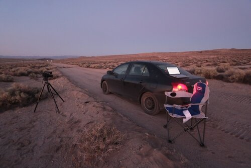
This is what an earthquake chase looks like. At least there is time to read Stormtrack and post!

july1819a.jpg

A lot of the M3s have DYFI (did you feel it) reports on the USGS site, but I have yet to feel one. My first night here, I had cameras rolling when a M3.4 hit close by. I didn't feel it and the objects I had pointed the cameras at (water bottles and coat hangers) didn't show any movement. With the 3s I'd assume you'd need it to be very shallow and very close to feel it, though the felt reports for some of the 3s are a good distance away.

Here is the realtime quake site where you can see the reports:
 
This is what an earthquake chase looks like. At least there is time to read Stormtrack and post!

Where/how far was any (even minor) fault line from that current position you had there ?
Like the fence/road images..

did have other info in here, but just seemed not to fit as partially off track, not really more about detection and pre-warn.
 
Last edited:
The surface rupture from the M 7.1 event is visible on the road just ahead there. I targeted here since a lot of the aftershocks have been pretty close to this spot, at least the ones I have access to. The rest of them are inside the military base to the north.
 
I've been sitting out in the quiet, calm desert night for hours, and just experienced an M 2.9 centered very close by, about a mile away and 7km deep. I didn't feel any shaking, but there was a clear low rumble that sounded like distant thunder. The sound was in the direction of the quake (just to my north). Pretty amazing.
 
Last edited:
I've been sitting out in the quiet, calm desert night for hours, and just experienced an M 2.9 centered very close by, about a mile away and 7km deep. I didn't feel any shaking, but there was a clear low rumble that sounded like distant thunder. The sound was in the direction of the quake (just to my north). Pretty amazing.

I had headed out your way to experience that same thing yesterday.
Got sidetracked and wound up in Tulsa at a Cherokee Nation trinket store.
Good friend is part Cherokee. could not reset buying her some items and then headed back home.
Just got home. Maybe try again in a couple weeks.
 
Back
Top