Spencer Dant
EF0
An incredibly marginal day that was seemingly massacred throughout the warm sector by widespread morning convection and poor recovery ended up cranking out one of my favorite tornado sequences ever, and I chased it in work clothes.
Ahead of the meandering cold front, a capping inversion kept convection to a minimum. I targeted the Illinois-Wisconsin border where some sort of differential heating zone had set itself up. This pseudo-boundary had a north-to-south component to it but nosed further west of Lake Michigan around here, so I thought a storm had the best chance to go up, mature, and briefly produce before heading out over Lake Michigan and obviously out of my range. The first storm to go up was closer to Milwaukee, so I drove northward, watching from a distance of about 20 miles southeast with it moving toward me. It was powerless and generally looked pretty sad, but the low levels were okay and it had a fair shot before it swept out over the lake.
In the meanwhile, I had been watching an updraft grow and fizzle in the ballpark of my initial target in far southern Wisconsin. I headed south to meet it, conveniently narrowing my distance to home if it failed to blossom. It took its time, and as the path of the storm crossed with mine it was only worth following out of sheer boredom and the fact that I was at most 10 minutes from home if it didn't turn out to be worth it.
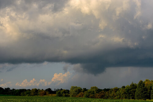
The storm slowed to a slightly closer to reasonable 40-45 knots as it neared Lake Michigan and I noticed that the base had some shape to it. I've lived here in northeastern Illinois long enough to know what the lake breeze can do - storms interact with cool surface air in the nearshore environment, begin to spin, and take on some cool structural shapes. That said, they're usually harmless. I was going to follow it - if nothing else, it was directly ahead of the cold front, so I could watch it over the lake for some quick waterspouts. This one skipped that phase and instead quickly formed a bowl shaped meso over land, taking on classic supercell characteristics in the lowest kilometer. Within minutes, I had reported this rotating meso to the NWS in Chicago via Twitter, a report that I'm sure fell on reasonably deaf ears given the nonexistent radar returns and generally anemic nature of the "storms" that day to that point. The storm, though, had come together.
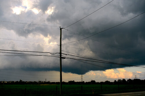
The clearing I found in order to take this photo turned out to be where my chase ended as I never moved again. There was no need. 60+ knot 500s kept the base clear of precip, and the prospect of taking on a town of 60,000 during rush hour in order to position closer was just not worth it. With the lake three miles to my east, I knew I would see anything that happened, provided it happened within the next 15 minutes before the storm was gone from view.
Spoiler alert: it didn't need 15 minutes.
Video from a resident of Waukegan, Illinois showed an uncondensed tornado crossing a busy intersection at approximately 6:42 PM. One video showed it flipping a car; another showed it hitting someone in their car. I took this photo at 6:41 PM. This is likely the exact moment this tornado touched down.
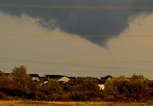
Fortunately, this tornado took about 3 minutes to complete the remaining 2 miles of its march to Lake Michigan. Were the following sequence to occur on shore on the north side of Waukegan and into Beach Park, we would be discussing a significant, potentially violent, yet unwarned tornado in a heavily populated area not built to withstand such an event during the rush hour on a weekday. These photos were all taken between 6:46 PM and 6:49 PM.
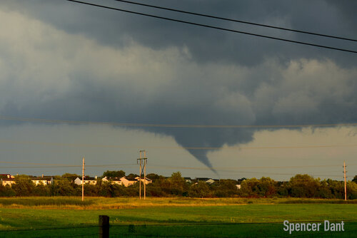
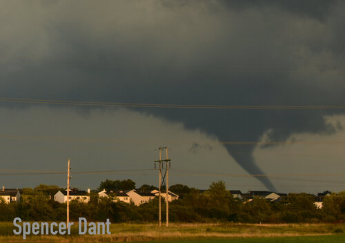
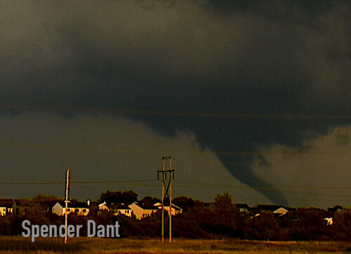
Despite being a tornadic waterspout, this tornado was mean. The motion was intense, far more than the low-end EF1 rating on land would suggest. Instead of roping out and dissolving, it simply developed an anticyclonic sister, which briefly condensed and then died. While it looked as if that was the end of that, it did not manage to take down the cyclonic twin. Instead, a new mesocyclone began to develop on the back side of the older tornado. Both grew fairly large, and while my view of the horizon was cut off and the distance between myself and the storm was pushing 10 miles, I honestly think that this photo might be my favorite of the day simply because it shows the raw ferocity of this storm that barely warranted a radar return just 20 minutes ago.
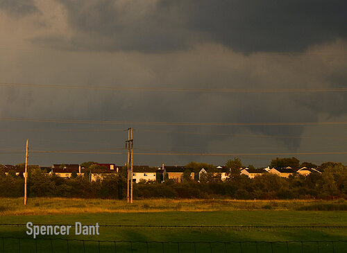
I have no doubt that this storm continued to cycle as it went out over the lake. I need to buy a boat.
The tornado that traversed along the Waukegan-Beach Park edge officially touched down under 3 miles from my apartment. My drive home from where I sat and watched this transpire was 6 minutes, and that was while seemingly hitting only red lights. I don't think I could beat that mark, and I certainly don't want to anyway.
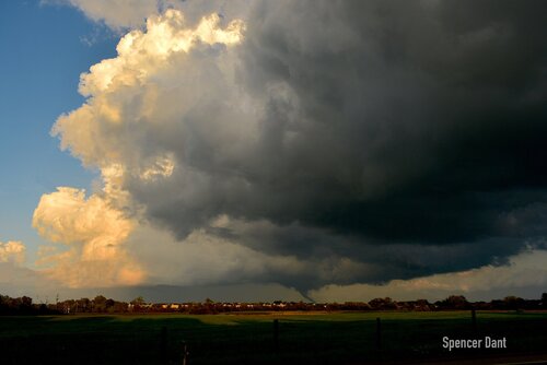
Here is one wide shot for the road, showing a fairly weak updraft with at best barely healthy cumulus but a big RFD cut and a classic tornado.

Ahead of the meandering cold front, a capping inversion kept convection to a minimum. I targeted the Illinois-Wisconsin border where some sort of differential heating zone had set itself up. This pseudo-boundary had a north-to-south component to it but nosed further west of Lake Michigan around here, so I thought a storm had the best chance to go up, mature, and briefly produce before heading out over Lake Michigan and obviously out of my range. The first storm to go up was closer to Milwaukee, so I drove northward, watching from a distance of about 20 miles southeast with it moving toward me. It was powerless and generally looked pretty sad, but the low levels were okay and it had a fair shot before it swept out over the lake.

In the meanwhile, I had been watching an updraft grow and fizzle in the ballpark of my initial target in far southern Wisconsin. I headed south to meet it, conveniently narrowing my distance to home if it failed to blossom. It took its time, and as the path of the storm crossed with mine it was only worth following out of sheer boredom and the fact that I was at most 10 minutes from home if it didn't turn out to be worth it.
The storm slowed to a slightly closer to reasonable 40-45 knots as it neared Lake Michigan and I noticed that the base had some shape to it. I've lived here in northeastern Illinois long enough to know what the lake breeze can do - storms interact with cool surface air in the nearshore environment, begin to spin, and take on some cool structural shapes. That said, they're usually harmless. I was going to follow it - if nothing else, it was directly ahead of the cold front, so I could watch it over the lake for some quick waterspouts. This one skipped that phase and instead quickly formed a bowl shaped meso over land, taking on classic supercell characteristics in the lowest kilometer. Within minutes, I had reported this rotating meso to the NWS in Chicago via Twitter, a report that I'm sure fell on reasonably deaf ears given the nonexistent radar returns and generally anemic nature of the "storms" that day to that point. The storm, though, had come together.

The clearing I found in order to take this photo turned out to be where my chase ended as I never moved again. There was no need. 60+ knot 500s kept the base clear of precip, and the prospect of taking on a town of 60,000 during rush hour in order to position closer was just not worth it. With the lake three miles to my east, I knew I would see anything that happened, provided it happened within the next 15 minutes before the storm was gone from view.
Spoiler alert: it didn't need 15 minutes.
Video from a resident of Waukegan, Illinois showed an uncondensed tornado crossing a busy intersection at approximately 6:42 PM. One video showed it flipping a car; another showed it hitting someone in their car. I took this photo at 6:41 PM. This is likely the exact moment this tornado touched down.

Fortunately, this tornado took about 3 minutes to complete the remaining 2 miles of its march to Lake Michigan. Were the following sequence to occur on shore on the north side of Waukegan and into Beach Park, we would be discussing a significant, potentially violent, yet unwarned tornado in a heavily populated area not built to withstand such an event during the rush hour on a weekday. These photos were all taken between 6:46 PM and 6:49 PM.


Despite being a tornadic waterspout, this tornado was mean. The motion was intense, far more than the low-end EF1 rating on land would suggest. Instead of roping out and dissolving, it simply developed an anticyclonic sister, which briefly condensed and then died. While it looked as if that was the end of that, it did not manage to take down the cyclonic twin. Instead, a new mesocyclone began to develop on the back side of the older tornado. Both grew fairly large, and while my view of the horizon was cut off and the distance between myself and the storm was pushing 10 miles, I honestly think that this photo might be my favorite of the day simply because it shows the raw ferocity of this storm that barely warranted a radar return just 20 minutes ago.

I have no doubt that this storm continued to cycle as it went out over the lake. I need to buy a boat.
The tornado that traversed along the Waukegan-Beach Park edge officially touched down under 3 miles from my apartment. My drive home from where I sat and watched this transpire was 6 minutes, and that was while seemingly hitting only red lights. I don't think I could beat that mark, and I certainly don't want to anyway.
Here is one wide shot for the road, showing a fairly weak updraft with at best barely healthy cumulus but a big RFD cut and a classic tornado.
