Susan Strom
EF5
Monsoon is official in Phoenix, Arizona as of Sunday, July 2. Phoenix reached three consecutive days of 55 degree average dewpoint. Typical start is July 7 so it is a little early.
Tucson's monsoon typically begins before Phoenix, as Tucson has to reach a 54 degree avg dewpoint for three consecutive days. They have had storms there for several days. Southern Arizona is also closer to Old Mexico so the monsoon flow reaches there first. To get to Phoenix it has to cross more land including the Central Deserts. This has been no obstacle however, lightning has been around the Valley last 7 nights and there is good chasing in the Central Deserts and many other places.
Favorable places that seem get storms with some regularity and local notes:
Mogollon Rim, Apache Sitgreaves to Show Low
Notes: Largest ponderosa pine forest in the world, but looking off the Rim one can get spectacular views. You will stand on a 1,000-2,000 foot cliff (edge of Colorado Plateau) with eagle-eye views. Road warning: Watch for elk. Steep grades, highly mountainous terrain.
Benson and Willcox and Willcox playa (lake bed)
Notes: Excellent chasing but closer to the Mexican border. Guaranteed you will be stopped by Border Patrol but that's ok. Watch for activity, keep it always in your mind.
Wickenburg area
Notes: Favorable. Landscape is Sonoran Desert terrain; saguaro cactus and spectacular Joshua Trees nearby. Roads: 2-lane. Watch for flash floods and people who don't know how to pass. Wickenburg is a nice Western town. Don't count on too much outside near there, Congress, Yarnell are still listed as ghost although a few people live out there.
Prescott
Notes: Fantastic area to chase. Mountainous, with some steep and curvy mountain grades. Sweeping views in places, big storms. Lots of services.
Bullhead City/NW corner and Kingman
Notes: Colorado River towns. Desert heat is most extreme in this part of the state. It is not uncommon to reach over 120 degrees. Scenic terrain; needle-mountains.
Globe to Safford across San Carlos Apache Tribal lands.
Notes: You can drive highway 70 between towns. Very few services for about 1 hour, so be sure to have a full tank. Tribal permit is required to go off highway in most places, and permit office closes at 4pm but there is a Circle K in Globe where you might be able to get one. Globe and Safford are not on Indian land and there are many services in both. Terrain is vast, mostly wild. Mt Graham is nearby; nearly 11,000 ft.
Canyon country (N AZ, S UT and four corners area)
Distances and landscape on the plateaus are so big it is proposterous. The North Rim of the Grand Canyon is a lightning hotspot. Page is the closest decently-sized town nearby (nearby is a relative term). Page sits on the edge of Lake Powell, a body of water with 2,000 miles of shoreline. Terrain consists of steep cliffs, seemingly bottomless gorges, rock formations. Keep the gas tank full (really). The size of the place...it is too big for humans. LOL
Phoenix Valley of the Sun:
Notes: Phoenix proper has strong heat island effect. Best areas near the Valley where storms always seem to hang out: Apache Junction, Florence, Queen Creek, Gold Canyon, Superior, Fountain Hills, Black Canyon City and New River, Cave Creek/Carefree, White Tank Mountains on West Side, far north Scottsdale (the perimeter of the Valley, basically).
Central Deserts (south central Arizona)
Notes: Landscape is basin & range topography. You will see mountains and peaks then flat areas. Small towns only, Casa Grande being the biggest. Truck stops and services available along I-10. Interstate 8 is a little more isolated although it is a storm magnet. Here is a picture of Central Deserts topography, everything pretty much looks like this:
Even though the Central Deserts are 1-2 hours north of the border, activity can't be ruled out, so just be aware. However, there are some towns around, like Picacho, Eloy, Casa Grande, Marana, Gila Bend. Gas is available on I-10 but it is always a good idea to keep tank full and bring plenty of spare water. It is hot in the Central Deserts. Flash floods occur there too. The Central Deserts is a favorite chase place of mine, the land is open, visibility is 360 degrees.
Note: I don't chase near the border these days; nor would I recommend any chasing there until things cool down. Nogales, Sells, Lukeville, Douglas, all border towns plus Organ Pipe National Monument, Cabeza Prieta, Buenos Aires and other wildlife refuges...off my list for now. It is too much trouble and I have a million square miles of Arizona to choose from so there is no need to chase there at all with so much available.
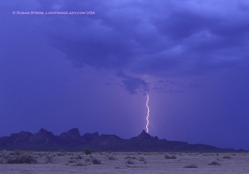
Monsoon chasing largely takes place at night. What to expect: Very high wind, over 100 mph gusts have been recorded. Microburst, haboob/sand wall/dust storm, intense lightning, torrential rain and flash flood.
Here's the general layout of Arizona:
North: Canyon country and plateaus. Immense landscape.
North central: Flagstaff, mountainous, alpine, ski country, bears, heavily forested pine/aspen.
Northwest: Alpine descending to Mojave desert (hot, harsh, with needle-mountains).
Northeast: Navajo nation, plateaus, Monument Valley. Think "John Wayne".
Central: Mogollon Rim country, Prescott, Sedona red rock country, alpine. Ghost town central!
West central: Wickenburg "western" ranch terrain to Colorado River towns and desert areas (hot) at CA state line. The closer you get to California desert, the hotter it is.
East central: Entirely alpine, mountain towns, looks like Colorado, White Mountains, deer, heavily forested. Cool.
South central: Phoenix, Central Deserts (can be remote), varying from Sonoran zone (saguaro cacti to drier desert conditions). The foothills contain very lush and interesting desert foliage and ascends in the northerly direction to more alpine terrains (such as Payson).
East south central: Mining country, extreme cliffs and rugged terrain to town of Globe and Salt River Canyon. Alpine further east. San Carlos Apache country too.
West south central: Extreme desert terrain, very harsh. Rugged Kofa range, town of Quartzsite. Think of camels.
Southern: Sky island country and borderlands. Major city: Tucson. Sky island = sharp rise of a high peak from desert floor, 8-9,000 ft elevation gain almost instantly. Examples: Mt. Graham, Mt. Lemmon, forested and alpine at top, aspen, bears, ferns, the whole nine yards. You can get up on a sky island and look at views, you can even see into Mexico.
Southeast: Prairie/grassland mixed with yucca and chaparral and mountains. Wetter, receives more moisture. Miles between towns. There is even a wine country there called Elgin Sonoita.
Southwest: Extreme Sonoran Desert terrain to Yuma, AZ. Isolated, hot. Rich cactus life. Very few towns. Yuma and Ajo (small). Border concerns. Tohono O'Odham (Desert People) tribal land. They are experts at desert life.
Lightning has been plentiful last several nights. It has been great chasing it. I'm a little tired")
Tucson's monsoon typically begins before Phoenix, as Tucson has to reach a 54 degree avg dewpoint for three consecutive days. They have had storms there for several days. Southern Arizona is also closer to Old Mexico so the monsoon flow reaches there first. To get to Phoenix it has to cross more land including the Central Deserts. This has been no obstacle however, lightning has been around the Valley last 7 nights and there is good chasing in the Central Deserts and many other places.
Favorable places that seem get storms with some regularity and local notes:
Mogollon Rim, Apache Sitgreaves to Show Low
Notes: Largest ponderosa pine forest in the world, but looking off the Rim one can get spectacular views. You will stand on a 1,000-2,000 foot cliff (edge of Colorado Plateau) with eagle-eye views. Road warning: Watch for elk. Steep grades, highly mountainous terrain.
Benson and Willcox and Willcox playa (lake bed)
Notes: Excellent chasing but closer to the Mexican border. Guaranteed you will be stopped by Border Patrol but that's ok. Watch for activity, keep it always in your mind.
Wickenburg area
Notes: Favorable. Landscape is Sonoran Desert terrain; saguaro cactus and spectacular Joshua Trees nearby. Roads: 2-lane. Watch for flash floods and people who don't know how to pass. Wickenburg is a nice Western town. Don't count on too much outside near there, Congress, Yarnell are still listed as ghost although a few people live out there.
Prescott
Notes: Fantastic area to chase. Mountainous, with some steep and curvy mountain grades. Sweeping views in places, big storms. Lots of services.
Bullhead City/NW corner and Kingman
Notes: Colorado River towns. Desert heat is most extreme in this part of the state. It is not uncommon to reach over 120 degrees. Scenic terrain; needle-mountains.
Globe to Safford across San Carlos Apache Tribal lands.
Notes: You can drive highway 70 between towns. Very few services for about 1 hour, so be sure to have a full tank. Tribal permit is required to go off highway in most places, and permit office closes at 4pm but there is a Circle K in Globe where you might be able to get one. Globe and Safford are not on Indian land and there are many services in both. Terrain is vast, mostly wild. Mt Graham is nearby; nearly 11,000 ft.
Canyon country (N AZ, S UT and four corners area)
Distances and landscape on the plateaus are so big it is proposterous. The North Rim of the Grand Canyon is a lightning hotspot. Page is the closest decently-sized town nearby (nearby is a relative term). Page sits on the edge of Lake Powell, a body of water with 2,000 miles of shoreline. Terrain consists of steep cliffs, seemingly bottomless gorges, rock formations. Keep the gas tank full (really). The size of the place...it is too big for humans. LOL
Phoenix Valley of the Sun:
Notes: Phoenix proper has strong heat island effect. Best areas near the Valley where storms always seem to hang out: Apache Junction, Florence, Queen Creek, Gold Canyon, Superior, Fountain Hills, Black Canyon City and New River, Cave Creek/Carefree, White Tank Mountains on West Side, far north Scottsdale (the perimeter of the Valley, basically).
Central Deserts (south central Arizona)
Notes: Landscape is basin & range topography. You will see mountains and peaks then flat areas. Small towns only, Casa Grande being the biggest. Truck stops and services available along I-10. Interstate 8 is a little more isolated although it is a storm magnet. Here is a picture of Central Deserts topography, everything pretty much looks like this:
Even though the Central Deserts are 1-2 hours north of the border, activity can't be ruled out, so just be aware. However, there are some towns around, like Picacho, Eloy, Casa Grande, Marana, Gila Bend. Gas is available on I-10 but it is always a good idea to keep tank full and bring plenty of spare water. It is hot in the Central Deserts. Flash floods occur there too. The Central Deserts is a favorite chase place of mine, the land is open, visibility is 360 degrees.
Note: I don't chase near the border these days; nor would I recommend any chasing there until things cool down. Nogales, Sells, Lukeville, Douglas, all border towns plus Organ Pipe National Monument, Cabeza Prieta, Buenos Aires and other wildlife refuges...off my list for now. It is too much trouble and I have a million square miles of Arizona to choose from so there is no need to chase there at all with so much available.
Monsoon chasing largely takes place at night. What to expect: Very high wind, over 100 mph gusts have been recorded. Microburst, haboob/sand wall/dust storm, intense lightning, torrential rain and flash flood.
Here's the general layout of Arizona:
North: Canyon country and plateaus. Immense landscape.
North central: Flagstaff, mountainous, alpine, ski country, bears, heavily forested pine/aspen.
Northwest: Alpine descending to Mojave desert (hot, harsh, with needle-mountains).
Northeast: Navajo nation, plateaus, Monument Valley. Think "John Wayne".
Central: Mogollon Rim country, Prescott, Sedona red rock country, alpine. Ghost town central!
West central: Wickenburg "western" ranch terrain to Colorado River towns and desert areas (hot) at CA state line. The closer you get to California desert, the hotter it is.
East central: Entirely alpine, mountain towns, looks like Colorado, White Mountains, deer, heavily forested. Cool.
South central: Phoenix, Central Deserts (can be remote), varying from Sonoran zone (saguaro cacti to drier desert conditions). The foothills contain very lush and interesting desert foliage and ascends in the northerly direction to more alpine terrains (such as Payson).
East south central: Mining country, extreme cliffs and rugged terrain to town of Globe and Salt River Canyon. Alpine further east. San Carlos Apache country too.
West south central: Extreme desert terrain, very harsh. Rugged Kofa range, town of Quartzsite. Think of camels.
Southern: Sky island country and borderlands. Major city: Tucson. Sky island = sharp rise of a high peak from desert floor, 8-9,000 ft elevation gain almost instantly. Examples: Mt. Graham, Mt. Lemmon, forested and alpine at top, aspen, bears, ferns, the whole nine yards. You can get up on a sky island and look at views, you can even see into Mexico.
Southeast: Prairie/grassland mixed with yucca and chaparral and mountains. Wetter, receives more moisture. Miles between towns. There is even a wine country there called Elgin Sonoita.
Southwest: Extreme Sonoran Desert terrain to Yuma, AZ. Isolated, hot. Rich cactus life. Very few towns. Yuma and Ajo (small). Border concerns. Tohono O'Odham (Desert People) tribal land. They are experts at desert life.
Lightning has been plentiful last several nights. It has been great chasing it. I'm a little tired