11-20-13 to 11-26-13 winter storm: California to New England?

John Farley

Supporter
Joined
Apr 1, 2004
Messages
1,783
Location
Pagosa Springs, CO
Not going to try to list states on this one since it could extend all the way from California to New England, if it is able to interact enough with cold air in the northeast, though by and large probably a rain event there, at least in coastal areas. But it will be a long duration winter storm in places like southern CO and northern NM, and in some of those places the interaction of the back door cold front trying to push over the rockies into central and western NM, southwestern CO, southern UT, and parts of AZ with the strong cutoff low on the Pacific Coast will likely produce some highly unusual weather. In the Rio Grande Valley of nothern NM, for example, freezing rain and sleet appear possible as the warm, moist air ahead of the low pushes over the shallow cold air coming westward through the mountain gaps. Freezing rain is very rare in that area - I've only seen it there once in the last ten years - but it could occur with this storm. And freezing rain and sleet could also be widespread farther east from the plains of NM across the TX panhandle into parts of OK and KS - areas more familiar with those p-types than the Rio Grande Valley of nothern NM. Edit - actually, mixed precipitation is already occurring in some parts of the Plains and Midwest.

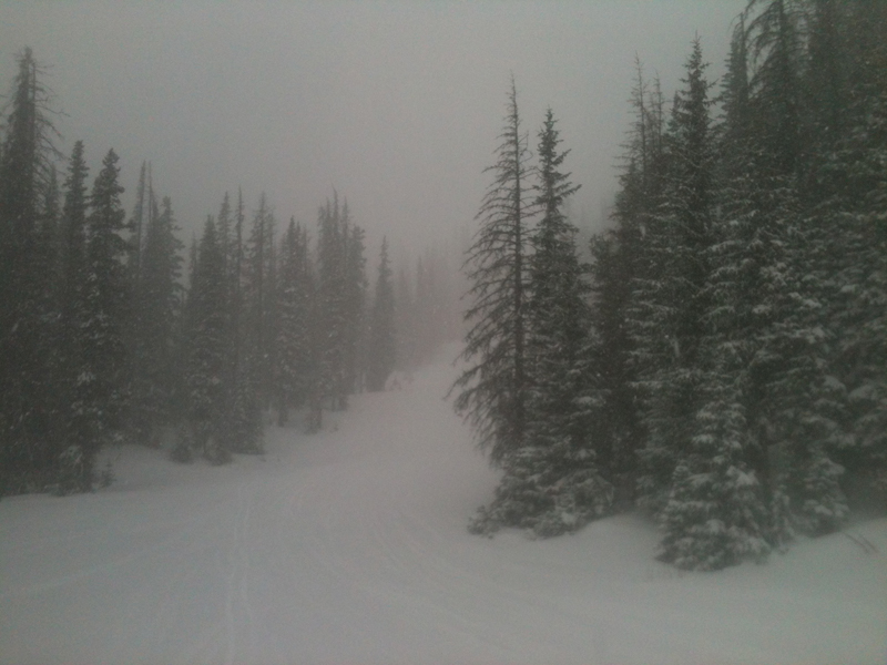
There is also the potential for very heavy snow accumulations in the mountains of northern NM and southern CO, especially the San Juans. I took the picture below this morning while skiing at Wolf Creek, showing the early stages of the storm. By this time about five inches had fallen, but with snow likely to continue much of the time until Sunday night or possibly Monday morning, 1 to 2 feet looks like a sure bet there, with 3 or 4 feet not at all out of the question.

snow112113.jpg
 
Last edited by a moderator:
This was the front passing "Stormtrack headquarters" at Norman, Oklahoma at 2:15 pm today. Looking south. We had a temperature drop of 19 degrees in one hour. Not really amazing, but definitely the mark of a typical strong polar front.

Z6LqX3u.jpg


As for the weather picture, I thought I'd cobble this together. It shows the mid-tropospheric (500 mb) patterns this evening with a basic "forecaster's perspective". I did something unusual here and showed the top of the cold air mass in thousands of feet, based on soundings in the central U.S. This shows that this is a very deep cold air mass, and one characteristic of these air masses is when you're topping out in the tens of thousands of feet, you can drive them southwestward across the Rocky Mountains. This pushes cold air into the Great Basin area, increases height falls out west, and helps feed baroclinic development of Southwest US systems like the one you see here in Arizona. The widespread snow going on in western Colorado is characteristic of these deeper types of air masses as isentropic lift (ascent from warm to cold) from Arizona to to Colorado like you see here takes place.

This polar outbreak isn't particularly cold but has enough volume and density to where it should quickly drive southward into Mexico and the Gulf, and in a couple of days we should see cyclogenesis in the area marked in the western Gulf of Mexico. This will be around where the front will ultimately stall, and with the warm waters here serving as an enormous source of moisture and latent heat this will be where we're looking for development of a baroclinic surface low that should quickly intensify and hit the eastern US later in the week. This is almost identical to the genesis of the March 1993 "Storm of the Century". I'm not saying we're going to get anything like that as this is a somewhat common mode of development, but things should at least be interesting out east soon.

9n2p213.jpg


It's not over.. the GFS goes for some serious arctic air production in the Canadian prairies in about a week and puts afternoon *highs* of 0F in the central Plains, 10F in Oklahoma, and 20 F in Texas during the first week of December, but anything beyond 168 hours is of course getting into crystal ball gazing, and I've been starting to suspect that there is are strong cold biases in the GFS toward the end of its runs in the winter. Regardless, the signal of arctic air cold production in about a week is valid, I think, and what comes out of that could be anywhere from nothing at all to something interesting.
 
Not a storm of the century yet, but certainly living up to expectations. The slow movement of the upper low has, as expected, been a significant factor in causing high precipitation totals. Lots of reports now of 35-40 inches in the higher elevations of the San Juans, including but not limited to the Wolf Creek ski area where I took the picture I posted above. 7-9 inches of snow in the Santa Fe NM, area, which is a substantial storm for there, though of course the mountains above the city regularly get much more. Around 2 inches of rain in some places in AZ and CA with serious flash flooding, and reports of up to 2 inches of icing in west TX and 15 inches of snow in western OK. Also big winds in the CA mountains, with at least two ski areas recording gusts over 100 mph. The highest I've seen was 120 mph at Alpine Meadows.

And it is not over yet, even in the Southwest. I think 4 foot snow totals are a pretty good bet somewhere in the San Juans, as the storm will continue to pump in moisture for another 24 hours or so.
 
Back
Top