Quad-State Supercell/Tornado Event (2021-12-10)

You guys can create the loop on your own...no purchase or special access required.

NOAA's Weather and Climate Toolkit (WCT): free to download and not terribly difficult to use: NOAA's Weather and Climate Toolkit (Viewer and Data Exporter)
Level II radar data files on that day: AWS S3 Explorer
You probably want KPAH, KNQA, and KHPX.
Yeah I just need to get home and get my Windows laptop out. I'm on my tablet at the moment, and the laptop I have with me is a Mac. My plan was to hunt down a level 3 archive to import to GRL3, but your way may well be easier to work with.

For Bowling Green, it'll be KOHX and KHPX. KLVX is further away than those two, and KPAH is about twice the distance as KHPX. I lived near there for several years and actually saw my first tornado east of Glasgow in 2006.
 
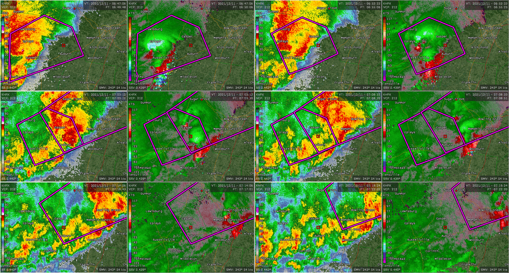
Here's an animation as the storm approached from the west-southwest and went through Bowling Green. Radar is KHPX which is to the west-southwest of the storm.

Initial circulation was going to miss Bowling Green to the north, then a new one developed to its south and went through Bowling Green, then a third one appeared to develop to the south and perhaps merge with the second one near the east edge of the Bowling Green metro.

BowlingGreen.gif
 
It looks like the damage surveys have mostly wrapped up at this point. Details might change, but I think we have our answers on the biggest questions for the most part. A couple of things:

1) The Memphis and Paducah offices' surveys do show breaks in the damage path in northwest Olbion County, TN, especially between Samburg and a location several miles west of Woodland Hills. The relevant part of the NWS Memphis damage survey statement is posted below (because the link used to obtain it will change as more PNSs are issued). The main tornado is listed as #4, whereas #5-7 are all short-lived EF0/1 tornadoes that occurred northeast of the end of #4's ending point.

2) Both of the big tornadoes (the AR/MO/TN side and the KY one) were rated as EF-4s. The KY one had maximum winds estimated at 190 mph. Apparently there has been a lot of chatter on Twitter especially about how some people are convinced that this tornado should have been rated EF5 based on damage pictures they saw. I think a lot of people forget that the "single-family house" damage indicator wind speed estimates only barely poke up into the EF5 range for the maximum degree of damage (DoD), and to get values greater than 200 mph requires evidence of well-constructed/engineered buildings being completely swept away. I suspect that most homes in this part of the country are not particularly well constructed, and hence even a completely-destroyed house cannot delineate winds that high.

This is still a significant event. But I think this is a great example of a case that illustrates how difficult it is to get a tornado rated EF5; not many damage indicators max out at values high enough to cross the EF5 wind speed threshold. I think it's entirely reasonable to speculate that the tornado had EF5 winds in it at some point, but without direct measurements or a structure that can resolve such wind speeds, final damage surveys just cannot justify giving that rating.

NWS Memphis PNS said:
000
NOUS44 KMEG 162202
PNSMEG
ARZ009-018-026>028-035-036-048-049-058-MOZ113-115-MSZ001>017-
020>024-TNZ001>004-019>022-048>055-088>092-171015-

Public Information Statement
National Weather Service Memphis TN
402 PM CST Thu Dec 16 2021

...NWS Damage Survey For 12/10/21 Tornado Event...

.OVERVIEW...
This statement summarizes the tornadoes produced by the long-track
supercell storm that moved from western Poinsett County AR, to
Obion County TN, and into Kentucky.

PLEASE NOTE...The information regarding tornado #4 below, from
Craighead County to Obion County, is based on data from ground
surveys. We are continuing to evaluate data from UAS, aircraft, and
satellites regarding the storm`s evolution as it moved through
Obion County. If the data from the supplemental sources reveals
additional critical information, this statement will be updated.


.4: Tornado From Craighead County to Obion County...

Rating: EF-4
Estimated Peak Wind: 170 mph
Path Length /Statute/: 80.3 miles
Path Width /Maximum/: 1800 yards
Fatalities: 5 (1 still missing)
Injuries: Unknown

Start Date: Dec 10 2021
Start Time: 07:07 PM CST
Start Location: 2.9 NNE Bay / Craighead County / AR
Start Lat/Lon: 35.7867 / -90.5511

End Date: Dec 10 2021
End Time: 08:36 PM CST
End Location: 2.6 ENE Samburg / Obion County / TN
End Lat/Lon: 36.3993 / -89.3113

SURVEY SUMMARY: The tornado produced its first damage north of Bay,
damaging storage and outbuildings. The tornado gradually strengthened,
and destroyed a farm tractor storage building along Highway 135
northwest of Lake City. The tornado possibly weakened slightly as it
crossed the St. Francis River area, but re-strengthened as it
approached Monette. Northern and northwestern portions of Monette
suffered significant damage. Homes and retail facilities had their
roofs partially or completely removed, and the roof of a nursing home
partially collapsed. One fatality and at least 5 injuries occurred in
the nursing home.

After leaving Monette, the tornado struck the northern portions of
Leachville, in northwestern Mississippi County. Several homes suffered
partial or complete roof loss in northwestern Leachville. A restaurant,
store, and cotton gin suffered considerable damage along Highway 77, and
numerous power poles were snapped. A fatality occurred in the store.
Anchors to the store`s metal frame were pulled out of the concrete
foundation. The tornado`s path was estimated at nearly a mile wide in
this area.

The tornado then approached the Little River area south of Hornersville,
near the Arkansas/Missouri state line. A stand of trees was debarked
east of Arkansas County Road 243. Several homes and mobile homes were
heavily damaged or destroyed along State Line Road. Additional
debarking of trees was noted. After exiting the Little River area, the
tornado damaged six metal electric transmission line towers. Five of
the towers had their top sections collapse, and one tower completely
collapsed.

The tornado seemed to reach its peak intensity as it moved into
Pemiscot County, Missouri. A home along County Road 454 was substantially
damaged. Farther northeast, near Highway J and County Road 407, two
homes were completely destroyed with debris carried off to the northeast.
A fatality occurred in one of these homes. Several vehicles, including
semi tractor-trailers, were blown off of the road as the tornado
crossed Interstates 55 and 155. Aerial and satellite imagery showed
ground scouring marks in this area across the Mississippi River.

In Lake County, the tornado significantly damaged trees with debarking
southwest of Wynnburg. Homes and shop buildings suffered substantial
damage north of Wynnburg. The tornado approached the Reelfoot Lake
area and caused significant damage to a hotel, convenience store,
restaurant, and camping facilities in the Cypress Point area. Two
fatalities occurred in this area, and one person was still missing as
of December 15. On the southeast shore of Reelfoot Lake, the tornado
damaged cabins and numerous recreational vehicles that were parked in
a storage area.

The tornado`s width was shrinking as it approached Samburg, however,
it was still strong enough to damage homes, businesses, and city
buildings in Samburg. Many homes suffered partial roof loss, and
several mobile homes were separated from their undercarriages. The
tornado continued northeast from Samburg, damaging several homes
along Old Samburg Road. The last observed damage was west of Treece
Road.


.5: Tornado in Western Obion County...

Rating: EF-1
Estimated Peak Wind: 90 mph
Path Length /Statute/: 0.6 miles
Path Width /Maximum/: 100 yards
Fatalities: 0
Injuries: 0

Start Date: Dec 10 2021
Start Time: 08:39 PM CST
Start Location: 5.1 ENE Samburg / Obion County / TN
Start Lat/Lon: 36.4192 / -89.2733

End Date: Dec 10 2021
End Time: 08:40 PM CST
End Location: 5.7 ENE Samburg / Obion County / TN
End Lat/Lon: 36.4236 / -89.2623

SURVEY SUMMARY: A brief tornado uprooted trees along Marvin
Vaught Road northeast of Samburg.


.6: Tornado #2 in Western Obion County...

Rating: EF-0
Estimated Peak Wind: 70 mph
Path Length /Statute/: 0.4 miles
Path Width /Maximum/: 50 yards
Fatalities: 0
Injuries: 0

Start Date: Dec 10 2021
Start Time: 08:43 PM CST
Start Location: 8.9 WNW Union City / Obion County / TN
Start Lat/Lon: 36.4430 / -89.2139

End Date: Dec 10 2021
End Time: 08:44 PM CST
End Location: 8.6 WNW Union City / Obion County / TN
End Lat/Lon: 36.4458 / -89.2078

SURVEY SUMMARY: A brief tornado damaged trees along Highway 22
west of Union City.


.7: Tornado near Shawtown Road in Obion County...

Rating: EF-0
Estimated Peak Wind: 80 mph
Path Length /Statute/: 3.1 miles
Path Width /Maximum/: 80 yards
Fatalities: 0
Injuries: 0

Start Date: Dec 10 2021
Start Time: 08:41 PM CST
Start Location: 6.4 NE Hornbeak / Obion County / TN
Start Lat/Lon: 36.4066 / -89.2241

End Date: Dec 10 2021
End Time: 08:44 PM CST
End Location: 9.5 NE Hornbeak / Obion County / TN
End Lat/Lon: 36.4420 / -89.1901

SURVEY SUMMARY: A tornado damaged trees and storage buildings
along Shawtown Road.
 
It looks like the damage surveys have mostly wrapped up at this point. Details might change, but I think we have our answers on the biggest questions for the most part. A couple of things:

1) The Memphis and Paducah offices' surveys do show breaks in the damage path in northwest Olbion County, TN, especially between Samburg and a location several miles west of Woodland Hills. The relevant part of the NWS Memphis damage survey statement is posted below (because the link used to obtain it will change as more PNSs are issued). The main tornado is listed as #4, whereas #5-7 are all short-lived EF0/1 tornadoes that occurred northeast of the end of #4's ending point.

2) Both of the big tornadoes (the AR/MO/TN side and the KY one) were rated as EF-4s. The KY one had maximum winds estimated at 190 mph. Apparently there has been a lot of chatter on Twitter especially about how some people are convinced that this tornado should have been rated EF5 based on damage pictures they saw. I think a lot of people forget that the "single-family house" damage indicator wind speed estimates only barely poke up into the EF5 range for the maximum degree of damage (DoD), and to get values greater than 200 mph requires evidence of well-constructed/engineered buildings being completely swept away. I suspect that most homes in this part of the country are not particularly well constructed, and hence even a completely-destroyed house cannot delineate winds that high.

This is still a significant event. But I think this is a great example of a case that illustrates how difficult it is to get a tornado rated EF5; not many damage indicators max out at values high enough to cross the EF5 wind speed threshold. I think it's entirely reasonable to speculate that the tornado had EF5 winds in it at some point, but without direct measurements or a structure that can resolve such wind speeds, final damage surveys just cannot justify giving that rating.

Having worked in the construction industry in Kentucky and Tennessee in my first handful of years after HS, I can vouch for most homes not being well constructed. Many of the pictures that I saw from people trying to bolster their case for an EF5 rating contained construction issues that were rather obvious to me, including several that I would have frankly been embarrassed by had it my own work.

People find it difficult to separate the emotion and see things objectively, and I understand that. It's not easy to compartmentalize in situations like this, and I've been called callous more than once in the past for being able to separate the two. Others simply don't have the understanding of construction that comes from either having done it for a living or from having an engineering background. Still more seemingly had preconceived notions from the night of the event based on radar returns that they probably were unable to let go of. All of this, of course, being human nature that is not easy to overcome.

While I agree that it may well have had EF5 winds at some point, I knew based on my familiarity with the area and quality (or lack thereof) of construction that it would have been difficult to obtain that rating. I don't, however, think the scale is "broken" like many on social media are contending, and have taken a fair amount of flack for saying as much.

On a side note, but still related, this event has me leaning much more towards civil engineering when I begin taking classes again. I've been trying to decide between mechanical and civil, and I've realized with all this that I still have a keen eye for discerning build quality, or lack thereof.
 
I've read the Memphis WFO damage surveys. So their longest path is confirmed to be at least a tri-state tornado. If not for the preliminary break in the path in Tennessee, it would be an unprecedented quad-state tornado with a path length very close to the 1925 tri-state.

The area of interest is only about 10 miles long near the TN/KY border, ENE of Samburg, TN. I propose it would be of historic interest to get drone footage to confirm the path, or lack thereof, along this 10 mile stretch.
 
The area of interest is only about 10 miles long near the TN/KY border, ENE of Samburg, TN. I propose it would be of historic interest to get drone footage to confirm the path, or lack thereof, along this 10 mile stretch.

I know drones have been used extensively in the surveys - any idea why they didn't fly that stretch?
 
I know drones have been used extensively in the surveys - any idea why they didn't fly that stretch?
To clarify, I don't know to what extent drones were used in that area for the surveys. But now that we know that 10 mile stretch is our focus, I think it would be good to do a continuous drone flight along that path (if one was not already done). We could get context and evidence of continuity along the route that may not be evident in the prior surveys.
 
As Jeff said, it would be rather shocking if they hadn't already done multiple flyovers of that stretch. They're very thorough and I highly doubt they would have skipped over that large of a detail. Between the published results and the radar evidence of a cycle, I'm pretty confident that they're not going to find evidence of continuity between the two paths if they haven't already.
 
I'm curious as to what has you so convinced that that stretch was not already surveyed for possible tornado damage. You seem to have a bias that there was in fact a tornado down in that gap and it's now up to CSI-type investigation to prove that the damage path was not continuous. Please justify.
 
You've undoubtedly read the MSM's pile-on criticism of the candle factory's management. I looked into it and have a perspective you may find to be interesting: The Tornado Warning System Failure at Mayfield, Kentucky

I'll be happy to answer any questions.
In your blog (which I am not allowed to comment on directly, apparently) you note that the text of the early warning included Mayfield as one of the affected locations. It looks to me like part of the Mayfield ZIP Code was inside the polygon, even though Mayfield proper was not. I have seen the public get confused when ZIP Codes don't line up exactly with municipal boundaries ... so, I am guessing that the routine that picks affected locations maybe includes ZIP Code hits
 
Back
Top