Post Your Coverage Maps!

Joined
Mar 6, 2005
Messages
890
Location
Palaven
Well - the SDS has definitely set-in chronically on the board now what with the DST and "vote for your SDS" threads......lol......and my keyboard is turning pale with the mere mention of lightbars.

So I got to thinking about what would actually help those of us who are intending on going out this coming season - no matter if it's just every weekend when we can manage it or if we're intending on spending 6+ weeks out there. Funnily enough - I came up with an Equip. post.

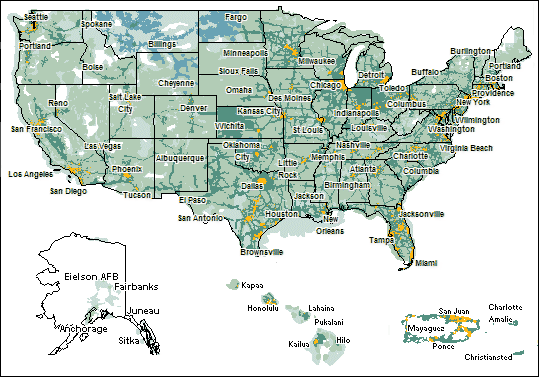
Not having chased hardcore for a couple of years......I am somewhat out of touch with the level of cellphone and GPRS/EDGE coverage out there. As we all know - sometimes when you're lost in the wilds of the Tx. Panhandle or somewhere on a reservation in southern SD - all you'd kill to do would be to get a decent window to make a cellphone call to someone in civilization who's in front of a computer.

So - would anybody care to tell me who their cell provider is and post their coverage maps for chase territory????

We are with Cingular......and I might try and find some of their maps if I can haul them off of their weird viewers online.

KL
 
Cingular Coverage Map - 2007 - Southern Plains:-

CingularSrnPlns2007.bmp


Cingular Coverage Map - 2007 - Northern Plains:-

CingularNrnPlns2007.bmp


Hopefully these images will display properly.
 
I wish that they would update there maps faster. Many places have 3g now and that does not show up on there online maps.
 
Sprint Coverage

This is Sprints National Map. It covers both in and out of network coverage. If you are using mobile broadband, it is supposed to be good for the entire area.


usmap.gif
 
Matt - what part of your Sprint map is the part that covers their hi-speed datacard/Sprintcard services (is that called GPRS??)? Is it the dark green along the interstates?

I'm still trying to figure out which random color from the Cingular map is their EDGE card coverage. :confused:

KL
 
Matt - what part of your Sprint map is the part that covers their hi-speed datacard/Sprintcard services (is that called GPRS??)? Is it the dark green along the interstates?

I'm still trying to figure out which random color from the Cingular map is their EDGE card coverage. :confused:

KL

I'm not Matt. but the high speed stuff on the Sprint maps is where the orange is.
 
I'm not Matt. but the high speed stuff on the Sprint maps is where the orange is.

Ye-eah.......I was thinking that, too. Which makes me even more confused - considering I know for a fact that a Sprintcard will work just fine between Shamrock and Amarillo!! I guess maybe it's a slower grade of connection or something......but hell I'm just fine with ANY connection! Guess I'm easily pleased. As for Cingular's map - it's anybody's guess!

KL
 
Karen

The solid orange areas (of various shades) indicate the Cingular Coverage and the "strength" of the coverage is indicated the shade. The striped areas indicate 3 party that may or may not support EDGE technology, but will allow Cell Phone cover as long as Cingular doesn't think you are abusing it.

According to the web, all the Cingular owned areas support EDGE Service. In practice? Get an external antenna for the best coverage. The dinky one on an EDGE (Air) card doesn't do well inside a vehicle. I've lost signal with the card where I still had full signal on the cell phone. Go figure.

In areas where there's plenty of population the service is generally pretty good. In areas where it's sparse, it gets worse and spotty. It's tough along the KS/OK line and really gets tough the further west you go from I-35.

Hope that helps.
 
re:Sprint coverage

I used to run a webcam from my tractor trailer. Using a Sprint S620 made by Novatel along with a Wilson mirror mount cell antenna I had coverage everywhere except the most remote parts of New Mexico/Arizona on I-40 and some remote areas of I-80. East of Albuquerque, Sprint service is by far the best. Even though the high speed stuff is only in the cities, the general coverage for the PCS network, which is what it all runs on, is quite good. I will make another post with the color coding description.
 
re: Sprint Coverage

Ok, Here is the color coding for the Sprint Map. Sorry I didn't put this with the map itself.

coverageKey_PCSarea.gif
Sprint Nationwide PCS Network
coverageKey_additional.gif
Additional PCS Service
coverageKey_PowerVision.gif
Sprint Power Vision Coverage Area
coverageKey_FuturePowerVision.gif
Future Sprint Power Vision Coverage Area
 
re:Sprint Coverage

The previous post was only half of the color code

coverageKey_AdditionalDigital.gif
Additional Digital Service
coverageKey_offnetwork.gif
Digital Roaming
coverageKey_Analog.gif
Analog Roaming
coverageKey_noservice.gif
No Service Available
 
Back
Top