Post Frontal in the High Plains

Joined
Jun 17, 2017
Messages
76
Location
Sherwood, Arkansas (Little Rock area)
I listened to a presentation today given by Reed Timmer

At about the 32:45 mark, he’s talking about events in the High Plains being mostly post-frontal events.

He said (roughly quoted), “With High Plains events you have to have a Cold Frontal passage usually, and then you play behind the front. When the winds switch back over to easterly, then the clouds clear and you get destabilization behind the front.

“They’re a lot different than the Dryline setups that you get in the Plains. And, because of the way they’re set up, a lot of times you get due easterlies all the way up to about a kilometer. So, if you look at the traditional indicies such as 0-1km shear, it doesn’t really show a very strongly sheared environment because you have easterlies similar in magnitude all the way up.

“But, between about a kilometer and 3 kilometers, they flip around to southwesterly or even more. So, you get a ton of shear through 0-3km.

“That’s why I always recommend using those indicies in the High Plains rather than the standard parameters used in the Plains.”

That’s all the info he gives about the subject. It really seems to be more of an aside in the video, but it’s made me interested because it seems so different than the things I’ve learned in basic meteorology courses.

Does anyone have suggestions of good resources to learn more about High Plains chasing? I’ve found a helpful detailed explanation of Upslope Flow by Jeff Duda in the post Forecasting Denver Area Tornadoes. And, a google search produces a lot of results, but they all seem to be little more than a one line definition of Upslope Flow.
 
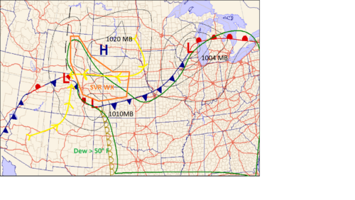
This is a great question. I've been an NWS met in the intermountain west (GJT/CYS) and high plains for the last 4 years and have chased quite a few post frontal setups. There isn't a ton of literature on high plains severe weather setups, but they follow a very easy to identify pattern from late spring through summer. Reed is right that many upslope setups are post frontal. However, its often the day after and beyond frontal passage that sees the greatest severe weather threat after winds have transitioned to easterly and frontal moisture has been established. Here is a quick graphic I threw together showing a very typical upslope severe weather day in June or July. Most of these events are with weak to moderate southwest flow aloft and broad western US troughing.

High Plains.png

The reason you get severe weather on the high plains after frontal passage is the moisture wrapping around behind the front and favorable upslope winds resulting from post frontal surface high pressure. Frontal overrunning at lower elevations transports moisture along and near frontal zones. Because the high plains sit at roughly 3 to 4k feet, they can "tap into" this moisture associated with the frontal zones. The elevation is also important because you dont need dewpoints as high as you do at lower altitudes. Low to mid 50s dews are sufficient for Coloraod and eastern Wyoming. This has to do with the pressure dependency of dewpoint and also the effect of heating of elevated terrain on equivalent potential temperature (thetaE) See this link for more info on just how important that is here: Heating and Moisture on Elevated Terrain

The surface winds behind cold fronts in this region of the country are north northeasterly but tend to gradually veer 12 to 24 hours after FROPA due to the post frontal high developing across the Dakotas. You don't want to chase the day of frontal passage because the winds remain too northerly and often undercut any storms. Usually the day after the front, the flow is easterly at the surface and through the lowest 1 to 2 km and can provide a broad but weak upslope lift to initiate storms. This broad lift often generates fog and low stratus that can hamper a chase day before it even starts. Too much moisture can be a problem. Looking for areas with thinner stratus can help narrow down a target.

You want to pay the most attention to are the areas of deep easterly flow low level flow along and north of the frontal zones. Often there is a stationary front connecting weak lows across colorado and the front range. The front serves as a demarcation for which most of the severe weather will be to the north and east of. This is due to the fact that the dryline has pushed further to the east across the southern plains and has created a "warm seclusion" across the higher terrain of the colorado plateau and rocky mountains. The stationary front will often act like a pseudo dryline helping to fire stroms and assist any fledgling updrafts that are generated from thermals across the foothills. Another important feature can be an inverted surface trough. This can also act as a storm trigger by increasing low level convergence. These are subtle northward pointing troughs often found across Wyoming, Montana, and western South Dakota.

Reed is also right that the shear can be impressive on these setups. The deep upslope flow can create an environment very favorable for supercells even when upper level winds are weak. 700 MB is roughly 1 to 2 km AGL for much of the high plains and can serve as a great indicator of shear strengths in the lowest levels. southerly and southeasterly 700s on a chase day are a good indication of deep upslope flow and strong turning in the lower levels. The other thing to look at are local terrain effects like the palmer divide, Cheyenne ridge, and the Denver Convergence and vorticity zone.These terrain features can be preferential storm formation areas and can also enhance low level shear and vorticity.

Dr. Chuck Doswell has a paper on some patterns of upslope severe weather that you may find useful: Doswell paper Hopefully this can give you an idea of what to look for. I plan on doing some research on synoptic patterns associated with high plains severe weather here in a few months. I think a comprehensive list of setup types would be beneficial.


http://Heating and Moisture on Elevated Terrain.
 
This is a great question. I've been an NWS met in the intermountain west (GJT/CYS) and high plains for the last 4 years and have chased quite a few post frontal setups. There isn't a ton of literature on high plains severe weather setups, but they follow a very easy to identify pattern from late spring through summer. Reed is right that many upslope setups are post frontal. However, its often the day after and beyond frontal passage that sees the greatest severe weather threat after winds have transitioned to easterly and frontal moisture has been established. Here is a quick graphic I threw together showing a very typical upslope severe weather day in June or July. Most of these events are with weak to moderate southwest flow aloft and broad western US troughing.

View attachment 20095

The reason you get severe weather on the high plains after frontal passage is the moisture wrapping around behind the front and favorable upslope winds resulting from post frontal surface high pressure. Frontal overrunning at lower elevations transports moisture along and near frontal zones. Because the high plains sit at roughly 3 to 4k feet, they can "tap into" this moisture associated with the frontal zones. The elevation is also important because you dont need dewpoints as high as you do at lower altitudes. Low to mid 50s dews are sufficient for Coloraod and eastern Wyoming. This has to do with the pressure dependency of dewpoint and also the effect of heating of elevated terrain on equivalent potential temperature (thetaE) See this link for more info on just how important that is here: Heating and Moisture on Elevated Terrain

The surface winds behind cold fronts in this region of the country are north northeasterly but tend to gradually veer 12 to 24 hours after FROPA due to the post frontal high developing across the Dakotas. You don't want to chase the day of frontal passage because the winds remain too northerly and often undercut any storms. Usually the day after the front, the flow is easterly at the surface and through the lowest 1 to 2 km and can provide a broad but weak upslope lift to initiate storms. This broad lift often generates fog and low stratus that can hamper a chase day before it even starts. Too much moisture can be a problem. Looking for areas with thinner stratus can help narrow down a target.

You want to pay the most attention to are the areas of deep easterly flow low level flow along and north of the frontal zones. Often there is a stationary front connecting weak lows across colorado and the front range. The front serves as a demarcation for which most of the severe weather will be to the north and east of. This is due to the fact that the dryline has pushed further to the east across the southern plains and has created a "warm seclusion" across the higher terrain of the colorado plateau and rocky mountains. The stationary front will often act like a pseudo dryline helping to fire stroms and assist any fledgling updrafts that are generated from thermals across the foothills. Another important feature can be an inverted surface trough. This can also act as a storm trigger by increasing low level convergence. These are subtle northward pointing troughs often found across Wyoming, Montana, and western South Dakota.

Reed is also right that the shear can be impressive on these setups. The deep upslope flow can create an environment very favorable for supercells even when upper level winds are weak. 700 MB is roughly 1 to 2 km AGL for much of the high plains and can serve as a great indicator of shear strengths in the lowest levels. southerly and southeasterly 700s on a chase day are a good indication of deep upslope flow and strong turning in the lower levels. The other thing to look at are local terrain effects like the palmer divide, Cheyenne ridge, and the Denver Convergence and vorticity zone.These terrain features can be preferential storm formation areas and can also enhance low level shear and vorticity.

Dr. Chuck Doswell has a paper on some patterns of upslope severe weather that you may find useful: Doswell paper Hopefully this can give you an idea of what to look for. I plan on doing some research on synoptic patterns associated with high plains severe weather here in a few months. I think a comprehensive list of setup types would be beneficial.


http://Heating and Moisture on Elevated Terrain.

Thank you so much for taking time in the middle of the night to share your knowledge!

Your explanation is loaded with information and is easy to follow. The map you created makes it easy to envision (the yellow arrow lines help to clarify further).

I will read Dr. Doswell’s paper and also Johnathan Finch’s information about Potential Temperature and Mixing Ratio on Elevated Terrain.

My girlfriend and I are both photographers. We’ll be able to chase the first half of June this year. Your response has given me clear direction in what I need to learn and understand in order to get to see a photogenic High Plains tornado with an LP Supercell.
Happy to help! I saw your post a few days ago but didnt have time to get a full in depth response until last night(Bit of a night owl) Good Luck! The high plains are one of my favorite areas. its a challenging place to chase with limited roads. But it can provide some of the most beautiful storms.
 
Back
Top