Poor Media Use of Weather Terminology

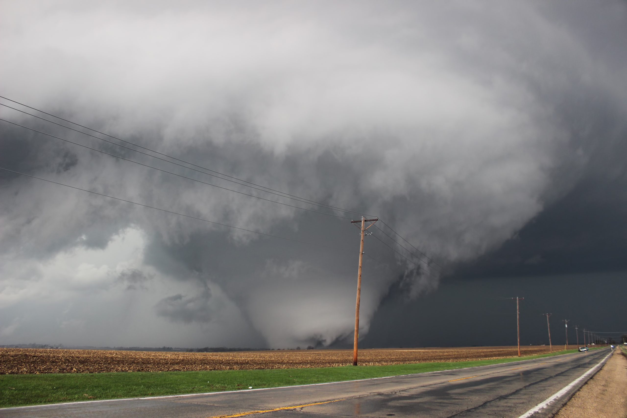
Good luck finding something worse than this. Thought it must be a joke at first, now I'm not so sure... They even used my pic of the Fairdale, IL tornado (legally).

At least they got the EF scale correct, despite associating it with hurricanes… That’s better than the Wall Street Journal, which cited the F scale (see link in my post immediately above this one).
 
To my knowledge, The Weather Channel was the first to use the term high water on air that I am aware of and for whatever insane reason its just been adopted by media far and wide.

I suspect that media use of "high water" comes form the warning road signs that officials often put up when blocking a road. Having said that, I went and looked at the US DOT Manual of Uniform Traffic Control Devices and "High Water" is not an approved sign. The only approved weather related signs are Road May Flood, Flood Gauge, Gusty Winds Area, and Fog Area.
 
I always cringe when I hear media say that severe weather or tornados are "rare" in December. The SPC WCM page says that the US averages 23 tornados per a year in December (1989-2013) . Rare is subjective.
 
Kentucky averages 0 tornadoes per December, and the areas outlooked today for tornadoes have never had a tornado in December there... So adding in that we've already had 80 reported - I'll give them a pass on "rare" :)
 
It's probably best to use a statistical approach if you want to be quantitative about adjectives like "rare". Considering the US averages ~1000 tornadoes per year and that the vast majority (like 90%) of those occur between 15 March and 15 July, that means even a handful of tornadoes in an off-month like December is indeed a pretty rare thing in the context of the CONUS annual counts.

10 tornadoes in a day at any time of the year or any location is already a 99.9th percentile event, even if it happens in May.

For example,...the NSSL folks use UH thresholds of like 99.5th, 99.6th, 99.7th, 99.8th, 99.9th, 99.95th for forecasting severe storms from NWP models due to how uncommon higher UH values are.
 
Kentucky averages 0 tornadoes per December, and the areas outlooked today for tornadoes have never had a tornado in December there... So adding in that we've already had 80 reported - I'll give them a pass on "rare"
That is true, and I had the same thought about giving them a pass on that one. There were a lot of national media saying that tornados are rare in December without qualifying that with Kentucky. I also remember the 12/26/2015 and the 10/20/2019 events in the DFW/North Texas area and how the media called them "rare". Texas averages 8 tornados a year in Oct and 4 in Dec. Sure Texas is a big place, and one could argue that statistically tornados are "rare" in these months even in Texas. My concern is that the calling them "rare" discourages public preparedness (although most of the public doesn't even prepare for common events). The other thing that bugs me, and this comes from being a Journalism minor in college, is that "rare" doesn't add anything but confusion to the story. My "rare", your "rare", and John Q public's "rare" are not the same thing. The same word can be interpreted very differently by different people.
 
Not so much wrong terminology, but wrong information due to misinterpretation/laziness. This morning, we at my local station have been reporting that Sunday's Fort Myers tornado was the first EF2+ in Florida since 1/17/2016. This came directly from an NBC wire script. That seems highly suspect to me. It's probably a conflation of two accurate facts; that it was the first January EF2+ in Florida since that date*, as well as the first one local to the southwest Florida media market. But the entire state, for all months of the year? Doubtful.

*Kind of ironic since a huge part of peninsular Florida was under a high risk on 1/22/2017 with a 30% hatched area for tornadoes, but saw no EF2+ tornadoes.
 
Not so much wrong terminology, but wrong information due to misinterpretation/laziness. This morning, we at my local station have been reporting that Sunday's Fort Myers tornado was the first EF2+ in Florida since 1/17/2016. This came directly from an NBC wire script. That seems highly suspect to me. It's probably a conflation of two accurate facts; that it was the first January EF2+ in Florida since that date*, as well as the first one local to the southwest Florida media market. But the entire state, for all months of the year? Doubtful.

You are correct. A quick search of NCEI's Storm Events Database confirms more than a handful of EF2 tornadoes after 01/17/2016, including an EF3 on 02/15/2016 in far NW Florida and another one in Pensacola a week later.

The most recent EF2+ tornado in Florida occurred last April, on the 10th.

Source: NCEI Storm Events Database for Florida over the past 5 years

FAIL
 
Yeah, looks like the SAPD probably should have added "NWS" in there somewhere - but the end result is the same. Advisories are useless. Thankfully they'll be gone entirely in the next year or two...
 
Classic news media error, from KATV in Little Rock:

Clinton National Airport cancels flights due to inclement weather

Airlines cancel their own flights; airports and the FAA do not.

And in the event of an airport closure, the airport authority (city/county/airport commission) does that, not the FAA.
 
I watched Fox Weather during last week's QLCS tornado event and the on camera meteorologist was having his assistant plot winds on the Doppler display and after clicking two pixels miles apart reported that "seeing a red near a green means this is a tight rotation, which we call gate to gate shear."

No, no we don't call it that :) Gate-to-gate shear is the difference between two touching pixels...
 
Back
Top