• After witnessing the continued decrease of involvement in the SpotterNetwork staff in serving SN members with troubleshooting issues recently, I have unilaterally decided to terminate the relationship between SpotterNetwork's support and Stormtrack. I have witnessed multiple users unable to receive support weeks after initiating help threads on the forum. I find this lack of response from SpotterNetwork officials disappointing and a failure to hold up their end of the agreement that was made years ago, before I took over management of this site. In my opinion, having Stormtrack users sit and wait for so long to receive help on SpotterNetwork issues on the Stormtrack forums reflects poorly not only on SpotterNetwork, but on Stormtrack and (by association) me as well. Since the issue has not been satisfactorily addressed, I no longer wish for the Stormtrack forum to be associated with SpotterNetwork.

    I apologize to those who continue to have issues with the service and continue to see their issues left unaddressed. Please understand that the connection between ST and SN was put in place long before I had any say over it. But now that I am the "captain of this ship," it is within my right (nay, duty) to make adjustments as I see necessary. Ending this relationship is such an adjustment.

    For those who continue to need help, I recommend navigating a web browswer to SpotterNetwork's About page, and seeking the individuals listed on that page for all further inquiries about SpotterNetwork.

    From this moment forward, the SpotterNetwork sub-forum has been hidden/deleted and there will be no assurance that any SpotterNetwork issues brought up in any of Stormtrack's other sub-forums will be addressed. Do not rely on Stormtrack for help with SpotterNetwork issues.

    Sincerely, Jeff D.

Level 3 radar blind spot in velocity data has chaser safety implications

Joined
Jan 14, 2011
Messages
3,447
Location
St. Louis
I learned about a blind spot in radar data I was previously unaware of that has safety implications for chasers. This may be one of those things that everyone else already knows about and I'm just late to the party, but I figured I might not be the only one.

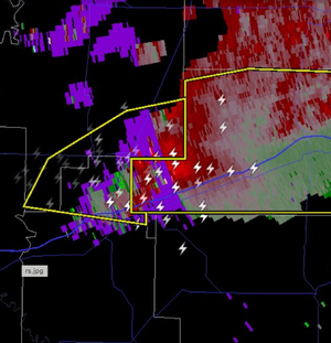
There are blackouts in the velocity data (BV, SRV) we use all of the time that can result in couplets going completely undetected. In a nutshell, there are large gaps/holes in velocity data that mostly occur in "RF rings" at a certain distance from the radar. These occur mostly within 100 miles of the radar, but can happen at much closer distances. They are large enough to completely obscure small-scale features including velocity couplets.

Level 2 and displays like Radarscope's Super-Res will show these data holes in their raw form (presented as purple-shaded echoes in RS). But some Level 3 data displays, including GRLevel3, employ some type of smoothing/interpolation that can deceptively hide the presence of a couplet that is being obscured by these holes.

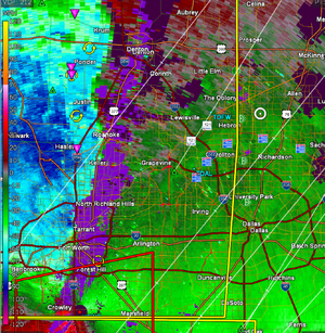
It may be coincidental, but I've found myself in multiple situations in the past few months where I was in the immediate vicinity of a rain-wrapped meso within these blackout areas in which I had zero awareness of the presence/intensity of a circulation. I had one on October 30 of last year when a storm's RFD surge in St. Charles, Missouri was completely within a velocity blackout zone on both the KLSX and TSTL radars, at very close range to both radars.

I posted this Twitter/X thread with some examples from yesterday. There are some good technical responses by Peyton Camden:

 
Last edited:
I get the purple range folding on both RS and GRL3 all the time, I wonder if you have a settings or color table problem in GRL3. Here are 2 examples from GRL3. The top is the traditional "ring" a certain distance out from the radar. The second is very close to the radar and it occurs because the squall line is parallel to the radar beam (I have two other screen shots shortly after this and the range folding goes away).

6_45.png
5_07.png

Next time I am out, I will have to compare RS and GRL3 to see if there are major diffs.

As a side note for others, this occurs when the radar receives a return from a previous pulse during the listening period for the current pulse, making it impossible for the radar processing algs to accurately determine the wind's velocity
 
Late Sunday afternoon with the supercells developing in N Arkansas, SGF (the closest radar) had the "purple haze" (correct term: range folding) right over the supercells. The location of the range folding can be determined by the radar operator by adjusting the PRF (pulse repetition frequency) but -- I was shocked to learn during some tornadoes this past autumn -- some NWS people don't know what that is!!

The illustration from Dan is not SGF but it is the same issue.
 

Attachments

  • Screenshot 2025-03-31 at 11.09.25 PM.png
    Screenshot 2025-03-31 at 11.09.25 PM.png
    1.2 MB · Views: 2
The second type of purple haze occurs when more than one thunderstorm is located along the radar's beam in the wrong place (again, the distance of the issue changes with PRF setting) that the radar cannot differentiate between storms because the data gets to the antenna at about the same time as the closer storm (has to do with Nyguist Interval).
 

Attachments

  • Screenshot 2025-03-31 at 11.09.07 PM.png
    Screenshot 2025-03-31 at 11.09.07 PM.png
    2 MB · Views: 2
The screen captures I posted were from KNQA (Memphis). KLZK (Little Rock) also had the RF rings, but they weren't in the same place. I'll try pulling the data from the 10/30/24 example as it was showing on both St. Louis radars in the same place.
 
Ah I see - is changing that setting instantaneous/simple, or does it require something more complicated? As in, it can be continually adjusted to allow visibility of a storm?
 
Ah I see - is changing that setting instantaneous/simple, or does it require something more complicated? As in, it can be continually adjusted to allow visibility of a storm?
  1. Switching the PRF takes seconds.
  2. The radars I used switched in a few moments, but I don't know how long it takes an -88D. I'm sure it is less than a minute.
  3. Yes.
 
I pulled the archived Level 2 data from the October 31, 2024 event in St. Louis. This circulation prompted a tornado warning, passed very close to both radars and was partially obscured by the RF issue for a time on both radars. The KLSX RF looks like the line-parallel effect as Randy noted. My location observing this storm was right next to the TSTL radar site.

klsx.jpg

tstl.jpg
 
Last edited:
Great discussion. What I am wondering is I thought that original premise of post was that Dan was seeing range folding on RS but not on GRL3 for the same product, on the same radar, at the same time. I don't see how that is possible. His post doesn't show radar or time stamps, so it is hard to verify the assumptions there. Even if they did have time stamps, RS only gives one time and GRL3 gives both VT (volume time) and PT (product time), and i have no idea what time RS uses.
 
Unfortunately I didn't record a timestamp from the Wheatley, AR supercell, but I posted it to X at 9:29 PM CDT within 5-10 minutes of seeing it. I don't recall ever seeing the RF issue with SRV on GR, though it's possible I just might have missed it.

I'm wondering if GR's SRV is just plotting the raw vector sum of velocity plus storm motion, and since that value won't be "blank" with storm motion added in, there's no actual "hole" in the RF zones (zero data) that gets shown like BV does?

In GR I don't have any customization set other than pulling in a couple of placefiles, IE, it's the default color table for all products.
 
Back
Top