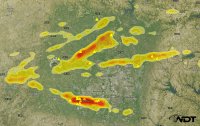
The DFW area has had some elevated supercells this morning producing baseball sized hail. Had an incredible hail roar as one passed about a mile north of me. However, interesting that a confirmed tornado has been reported east of Paris Texas. Temps look to be in mid to upper 50's there and mid 40 dewpoints. Seems to be the first time I've seen this with these observations.
-
While Stormtrack has discontinued its hosting of SpotterNetwork support on the forums, keep in mind that support for SpotterNetwork issues is available by emailing [email protected].
You are using an out of date browser. It may not display this or other websites correctly.
You should upgrade or use an alternative browser.
You should upgrade or use an alternative browser.
Elevated Supercells producing tornadoes
- Thread starter brentford
- Start date
rdale
EF5
I didn't see a confirmation - looks like the NWS updated to Funnel Cloud report. Was there something else?
PRELIMINARY LOCAL STORM REPORT...CORRECTED
NATIONAL WEATHER SERVICE SHREVEPORT LA
1028 AM CDT THU MAR 17 2016
..TIME... ...EVENT... ...CITY LOCATION... ...LAT.LON...
..DATE... ....MAG.... ..COUNTY LOCATION..ST.. ...SOURCE....
..REMARKS..
0935 AM FUNNEL CLOUD 4 NNE ANNONA 33.63N 94.89W
03/17/2016 RED RIVER TX TRAINED SPOTTER
LARGE TREE LIMBS DOWN... ROOF DAMAGE TO HOME ON CR 3300
rdale
EF5
Yeah, I think I saw the "Law Enforcement" tornado too but that's why I coined the term "Sheriffnado" 
Nick Copeland
EF0
I didn't see a confirmation - looks like the NWS updated to Funnel Cloud report. Was there something else?
There were two separate reports. One for a funnel and then another for a tornado reported by law enforcement. There was damage to some buildings in the area via Twitter from local sources.
Both SHV and SPC have to logged.
1440 ANNONA RED RIVER TX 3358 9491 TORNADO REPORTED HWY 82 AT CR 3210 REPORTED IN ANNONA (SHV)
rdale
EF5
Right, but the NWS sent out a survey team and they never issued a tornado report as a result.
Nick Copeland
EF0
I was just simply pointing out the funnel cloud report is a separate report from the actual tornado report that is on SPC and SHV site.
There may not be a survey report due to them not being able to survey the location yet. As of right now SPC and SHV are still reporting it as a tornado.
There may not be a survey report due to them not being able to survey the location yet. As of right now SPC and SHV are still reporting it as a tornado.
rdale
EF5
Per the update they sent out yesterday morning, they were out there yesterday. SPC will never change since it's just a preliminary log. If SHV doesn't send it in as a confirmed tornado, it just won't show up in StormData.
Gregg Schulz
Enthusiast
Upper 50s over mid 40s would be good enough for a tornado here in Wisconsin that time of year.
Jeff Wright
EF4
- Joined
- Apr 23, 2010
- Messages
- 406
The tornado on the cover of Grazulis' SIGNIFICANT TORNADOES tome--was that elevated--it looks like that has a high base.
Kevin Bowman
EF4
They are talking surface based storms compared to elevated, not the height of the cloud base.The tornado on the cover of Grazulis' SIGNIFICANT TORNADOES tome--was that elevated--it looks like that has a high base.
https://www.e-education.psu.edu/files/meteo361/flash/Section3/lifted_parcel0203.swf
Similar threads
- Replies
- 10
- Views
- 2K

