Chaser traffic post-mortem for 2019 season

Joined
Jan 14, 2011
Messages
3,239
Location
St. Louis
OK, now that the bulk of the "mainstream" chase season is over, let me make sure I'm correct. I like to quantify these things into hard facts which I will be including on my chaser traffic web page.

We had three (3) events this year where chaser traffic reached critical levels (chase-affecting and more than just sporadic/transient jams):

May 7: Vigo Park, Texas Panhandle (northeast of Tulia): A single viable target storm emerged toward the end of this Moderate Risk event at Tulia, attracting most chasers in the Panhandle. Chasers from the northern storm in Amarillo headed to the Tulia storm. A single road through the Palo Duro canyon, Highway 207, resulted in all chasers on the storm being funneled onto two roads, east-west 146 and north-south 207. The T-intersection of these two roads was the main "choke point".

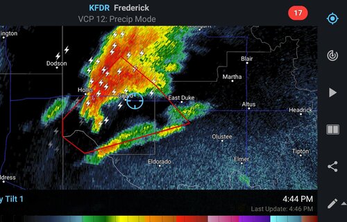
May 20: Mangum, Oklahoma: A High Risk was issued for an expected major outbreak in southern/central Oklahoma, atrracting a very large number of chasers. Instead of multiple storms, a single viable target storm evolved near Hollis, OK, attracting most chasers to it by the time it reached Mangum. I need some details from those of you who were there to fill in the blanks on where the choke points were and which highway had the worst traffic.

May 26: Lamar, Colorado: The impassable secondary roads and only one available paved highway near the storm funneled all chasers on the Lamar storm onto Highway 385 north. An accident involving chaser vehicles exacerbated the backup.

Amazingly enough, I did not encounter any of these situations - two due to factors beyond my control. On the 7th, I had to lose the storm and go to Tulia to get gas since there were no other stations on I-27 north of there. On the 20th, I got stuck on a dirt road as the storm crossed into Oklahoma, making me lose the storm and that traffic jam. On the 26th, I had given up on the Colorado target thanks to cold upstream inflow and was not there for that either, choosing instead to go to storms near Dodge City.

Nonetheless, if any of you have video of the traffic, or even better, a dashcam timelapse of the events, please let me know and I will link them on my page. I don't exclude any high traffic events, rather I aim to present an accurate, factual analysis of the chaser traffic issue.

As a reminder, the site is here:
 
I can chime in on the Mangum day. We were on the storm waiting for it to cross the Red River and saw the hazy tor near Gould. At that point chaser traffic wasn't that bad. We saw quite a few people but things were progressing nicely and there were no jams. It would not last. At this point in the day it became clear other targets were going to bust and I watched all the green dots, like a swarm of locust, diving south from I-40 and west from I-44. As you mentioned, on a 45 hatched, this was the only game in town, and I don't blame everyone for trying to desperately salvage the day.

We were actually near the front of the line. It wasn't bad for us, even as the Mangum tornado touched down, the hoardes hadn't arrived yet, but as we kept pursuit I only saw the number of headlights in my mirror increase. We pulled over again closer to town, and thats when dozens upon dozens of cars passed us. We managed to squeeze back in, near the middle of the line and it was game over from there. Didn't witness any baffoonery, but I don't understand why the line has to move at 35-40mph. DRIVE people, DRIVE. Old U.S. 283 and 44 were lost causes by that point, but so was the storm so we didn't really care. We sat there taking pictures of it gusting out and just let the easily hundreds of vehicles pass us. It took about half an hour, then we were alone again.mangumnightmare.PNG
 
I was on the Lamar Colorado storm. (regret not going after the storm down the dry-line in New mexico) As far as the convergence near Lamar, I was usually a near the front of the line but every time I looked in the mirror it seemed like the amount of headlights would double. There was an instance where someone ran a stop sign only to drive down the wrong side of the highway. I really hope there is something that can be done about the irresponsible scrub chasers. Chasing in the plains has been something I dreamed about since the age of 4 (27 now) and I finally got to do it the first time. I wonder if there would be a way to combat this by making it more difficult to get a hold of the SPC outlooks. I´m not sure if that would actually work, because of public safety or whatever, but I´m sure there is a good percentage of chasers who rely on that. Make people put their own forecasts together if they want to chase bad enough. I pride myself on chasing my own forecasts success or fail (only chased in IL/IA/IN until this year). It´s just a thought, but I think something like that would slow the numbers down, at least a little bit.
 
Lamar was the worst I've ever seen it in Colorado. I wasn't out on the previous two days. I suspect it's a combination of higher risk events that are more publicized or, in the latter case, the fact that it was Memorial Day weekend in the midst of a fairly active and well advertised system that produced a number of severe weather events. I don't like it any more than anyone else, but I concede that I also have no more right or entitlement to be on any public right-of-way than any other chasers.
 
I was able to get ahead of the Mangum storm by crossing the Red River one extra crossing to the east near Eldorado, and at that point I was running into very few chasers. I didn't get caught by the conga line until about halfway through the Mangum tornado's life. The biggest choke point I noticed with this particular storm was the actual town of Mangum itself.

With the Lamar day in Colorado, I ran into hardly any convergence at all until I was directly east of Eads at the intersection of Highway 96 and Rd 49(which ran straight north out of Lamar) where a chaser had ended up in a ditch while attempting to hook slice the storm. I cant speak for Highway 96 or 287, but Rd. 49 was a ghost town for a good while with very few chasers on it. I was able to double back around and go west of the traffic jam by utilizing a paved road just south of the intersection and actually managed to avoid a large chunk of the convergence. Despite all the complaining I had very few problems on this day with the EPIC CONVERGENCE™ people whined about non-stop. I do believe that if there was not the wreck with the two chasers and the other chaser in the ditch the convergence would not have nearly been so bad.

The biggest trend I've noticed with the higher traffic days this year is the people that follow the storm rather than position ahead accordingly are the people who end up in the convergence and whine up a storm.
 
My biggest issue isn't with people being out there per se, since as I previously stated, no one has any more right than another person to hop in an automobile and pursue a storm on a public right-of-way. It's a free society. However, there are two behaviors that are becoming epidemic and need to stop. I've seen more of these this year than EVER before. First, people need to learn how to safely and legally pull off of the roadway, park, and then re-enter the roadway. In particular there are more people than ever before parking illegally by being partially in the roadway, obstructing at least one lane of traffic. Furthermore, I cannot believe how many people stand in the road or aimlessly wander onto the roadway, including busy highways, just assuming the drivers will come to a complete stop. Highway 385 for example, which has posted speed limits of 65 mph, is not your own personal sidewalk. As a pedestrian you do have to yield to traffic in those situations. Yes, I realize that in congested areas drivers have a duty to remain diligent, drive defensively, and adjust one's speed accordingly, but enjoy a hot cup of Mea culpa if you get struck darting out in front of a vehicle with your camera because you assume any right-of-way, including an unpaved county highway in CO, is your own personal sidewalk (outside of those situations where a pedestrian does indeed have the legal right-of-way).
 
Our tornado count this year (so far) is six. We avoided serious chaser convergence by targeting secondary storms to the west and south. I'm not sure the plan to chase Eastern Colorado during the first week in June will pan out given the current models. I was hoping this period would offfer less convergence. Out of control chaser convergence is now a permanent legal and safety consideration while chasing. I consider the convergence issue more dangerous than the tornado risk since it's an uncontrollable x-factor once you enter the arena. Convergence will eventually lead to deaths, I have no doubt.
 
I think approaching from the east might help. See Devin's post above. In the other thread Ben reports no problem with Mangum, I'm guessing approaching from the east. We all know how it went from Texas.

In 2016 we never saw the infamous DDC road block. We'd swung around from the east and saw little if any chaser-con. We used state highways too. May 22, 2019 we didn't see anyone else approaching Miami OK from Kansas. More showed up later.

Worst chaser-con is usually a reaction. Proactive forecasting helps a lot. It's getting bad, but I believe still manageable most times.
 
Proactive forecasting helps a lot.

This. If you have a good forecast and understand what is going on, it's easy to anticipate the storm from visual clues. Stay ahead of the damn thing and snipe the tornado when it wraps up finally. As Mike Scantlin said, if he had a dollar for every idiot looking at RFD shelf clouds or scud, he'd have enough money to buy off an Oklahoma lobbyist and make chasing illegal.

Also, it helps to have an idea of the road network. I feel like the fact I knew there was 2 rivers near Mangum and only 1 highway (34) across the river south of town made me leave the tornado right after it touched down because I knew I needed to get on 34 and north before everyone else. I also was able to drop through the town of Hobart later on and get on 183 north ahead of the conga line of chasers because I knew my way around. Had I been on the storm earlier, I would have crossed the Red River near Childress on the very not-advertised bridge between el dorado and US62, or just done the el dorado bridge. Again, knowing the rivers and crossings is a huge advantage. Study them in the off season. Or don't, because I like having my home turf advantage.
 
On the Mangum day I was a little behind the ball and I can say that there was a crapload of cars on US 62 between Hollis and Duke and I was concerned with turning left onto 34. I was probably 15th in line to turn left at the intersection, but luckily there wasn't a mass of cars coming north on 34 yet and only had to wait a few minutes.

I did not foray into the Wiley area after the tornado reports on Lamar day, so I never experienced the jams people referred to there, but later near McClave on highway 196 there was quite a convoy, but luckily again not a mass of chasers coming up 287 at the time and turning left at that intersection went rather smoothly. Definitely the most congestion I've ever seen in Colorado. This also included many of problems that Risley brought up. I saw one guy stop in the travel lane on 196 to talk to a buddy he spotted on the side of the road for a few seconds. Honking ensued to get him moving again. Several vehicles, including what I believe were tours, not pulled off the road entirely, or blocking intersections, general gathering of the tour guests within the roadway. That seemed to be the worst day for general obliviousness by people with regards to their surroundings in the 10 days I was out.

I do have some dash cam footage from those days, but I'll have to check if I have any that would be of use as far as a congestion standpoint goes. I don't save everything.
 
For the Mangum tornado, we started off waiting for the developing storms to approach while sitting in Dickens Texas. We saw a couple of other chasers waiting there as well as the storms approached. On the first screen grab as the storm crossed hwy 70 North of Dickens, things were looking pretty good. The storm was trying to put one down there, but couldn’t quite get it done despite my prayers. I did notice a few more chasers at this point548DB0C7-629D-41F0-A442-A907811C7321.png

After the circulation cleared HWY 70 we headed North all the way to Matador because of concerns of what kind of conditions the secondary roads were in which now left us behind the storm playing catch up. The chaser traffic continued to increase as we continued to fall behind the storm. When the storm got to Mangum we decided to call it quits on the chase as we had no shot of ever getting into decent position again. The decision early on to hold steady on HWY 70 as the circulation crossed effectively ended our chase day. We just didn’t realize it at the time. The second screen grab was after we had called it a day.E4AED7DA-7E08-4AC5-B4FB-D6237367F206.jpeg
 
Yeah on the Mangum, OK day I thought the biggest challenge was getting through the town itself. Once we got past the town and northeast (which is where the storm stopped producing lol), we didn't really have any issues. Traffic ran a little slow at times, but it wasn't nearly as bad as the traffic around the town itself. Saw a lot of LEOs heading north toward the damage area and I generally go to great lengths to avoid that, so I can't really comment on that portion. As far as the other day, I wasn't out chasing so again, can't comment on it. Around Mangum I saw several cars that were involved in accidents including someone that drove straight into a guard rail. Not sure if they were a chaser or a local out watching the storm...
 
@Dan Robinson I chased all three, and you are accurate on all three.

Nothing to really add on the TX one. Roads and bottlenecks are correct. I think the video @Daniel Shaw took says it all.

For the OK one, the spotter network dots that @Todd Lemery posted tell the story perfectly.

For the Lamar storm, you're a little bit late on the convergence. The chaser convergence flowed 287 northbound, to 96 eastbound, to 385 northbound. Most vehicles were parked along 287 during the tornado. When it lifted, vehicles moved north along 287 to keep up with the storm. Most chaser traffic then went east on 96, and then north on 385. Both accidents (the SUV in the ditch, and the rear end collision occurred on 96, just east of 287. It did slow down traffic, backing up traffic along 287 northbound even more. But the slow down continued eastbound 96 and northbound 385.
 
My experience on May 20th was somewhat similar to that of Adam, Devin, Nick and others. I was on the Mangum storm about 30 minutes before the tornado began (according to the Wikipedia tornado list, I have yet to find a detailed survey with track map if indeed OUN has put one out), but still managed to miss it due to misplaying the day in other ways.

I set up along US 62 between Duke and Gould, OK shortly before the storm began to look impressive and potentially tornadic on radar (2144 UTC scan, attached). To me the reflectivity signature looked rather like the early stages of the Cullman storm on 4/27/11, and like that storm I anticipated it would soon produce multiple long-track EF3+ tornadoes and be just the first of numerous cells to do so on the day. After blasting like mad to get to the target area after spending the previous night in San Antonio I had limited opportunities to look over data and so assumed the outbreak was still unfolding as expected.

En route to this location after my pre-storm-intercept gas top off in Altus, I encountered quite a few other people who appeared to be observing the sky along the side of the road, but there were plenty of places to pull off and plenty of gaps in traffic to get back in.

Given the anticipated atmospheric conditions on this day and this radar signature, I expected the storm would likely have a large tornado on the ground by the time it crossed the highway 2-3 miles to my west. I had noticed the murky haze in the air, but didn't realized just how bad it was until this point. Chasers who were on the May 2003 sequence recalled not being able to see towers going up 30 miles away. On this day, it was impossible to see under an updraft base less than 10 miles to my southwest. For perspective, I was about the angle and distance that the ABC 33/40 skycam was able to clearly see the updraft tower, base and eventual tornado of the Cullman supercell. Between this lack of visibility and a very poor data connection/a new reflectivity image every 10-15 minutes on Radarscope and NO velocity/ I didn't want to venture any closer to where the base would cross the highway, and risk a violent tornado roaring up on me out of the murk to the southwest at 50 MPH.

After hanging around until it was apparent the base had crossed the highway without any evidence of a tornado in progress that I could see, I attempted to get back on the road and was immediately met by a solid string of headlights coming EAST, who had obviously been much closer than I was to where the base had crossed 62. It became apparent I was not going to find an opening to get in by waiting there, so I headed WEST until I was able to find an opening in Gould to spin a uie and join the conga line to Mangum, then Granite, then Hobart. Me and my Toyota Corolla had vowed to have no part of Oklahoma's infamous dirt/mud roads, so I was committed to the paved main roads with the rest of the horde. At this point it's a good thing the storm actually wasn't the cyclic tornado machine I had been anticipating going into the day, since all of us were essentially hook slicing it the whole way, with little discernible structure visible and now NO radar updates for me. Fortunately I didn't observe any egregious bad driving or get stuck behind the accidents. However, the slow movement of the line was frustrating (DRIVE, DRIVE! as Adam put it) and compounded by the person in front of me repeatedly slowing to less than 30 MPH to take pictures of featureless clouds and rain out the driver's window.

I finally got a visual on something resembling storm structure after getting through Hobart, and even my inexperienced eyes could tell it had gone to crap and was not, as someone put it in the TA thread for the day, at all behaving like a discrete cell in a maxed-out tornado environment. I decided to head towards Lawton to get back to "civilization" and hopefully some data coverage. When I finally did get a radar update, it confirmed my suspicion that not only had "my" (and 1,000 others') storm crapped out, but nothing much was really going on anywhere in Oklahoma in terms of tornadic activity. I made a futile attempt to blast south and reach a tornado-warned cell approaching the Wichita Falls area before dark, even though it was an HP meatball with likely no visibility either even if I had been able to get in front of it in daylight.

All in all not a very fun or rewarding 3,000 mile marathon round trip. It's hard to say whether it's more frustrating knowing that I could have gotten the tornado had I been a little more on the ball after the initial intercept, or just the fact that I never saw anything resembling photogenic supercellular structure even with that classic flying eagle reflectivity signature. No atomic bomb updraft tower, no mothership mesocyclone base, no ominous roiling wall cloud (with or without a tornado), it was all buried in murk and no-contrast haze.

Now I even have that at home thanks to the fires in Alberta...

Eventually I'll do a GoPro timelapse for Dan, of my "view" as the storm approached and crossed 62, and then the conga line all the way to Hobart.
 

Attachments

  • 20190520_222735.jpg
    20190520_222735.jpg
    334.7 KB · Views: 3
Last edited:
I would have crossed the Red River near Childress on the very not-advertised bridge between el dorado and US62, or just done the el dorado bridge.

That bridge on Hollis road is a no go if there is even a little bit of rain. It turned to mud 4 miles south of the Red River crossing. I looked on Google maps and saw pavement south and pavement north, but I didn't check all the way between. Thought I was being slick. I lost the Magnum cell that day because I got all the way down to the mud and had to backtrack out to Quanah to cross. There were maybe 4 others that went into that dead end with me. I probably passed another dozen on my way back out.
 
Back
Top