Best "non-chase day".

Mike Hollingshead

What is the best day you had when you didn't even know you were chasing and had zero plans to do so? Not just a day you didn't expect much but went out, but a day you didn't think you were chasing at all and something quickly came up.

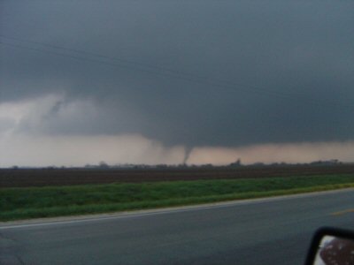
I was fixing stuff on the site and remembered that freak storm in 04 was on a day I had no real thoughts of chasing. Got done working, got a phone call, and was quickly back out the door. Normally if it seems remotely possible a good storm could happen I'm looking at stuff the second I get home to a computer. I got home and was checking e-mails(doh) when I got the informing phone call. I wasn't expecting anything worthwhile as I drove to the storm and thought I was wasting gas as there really was very little instability and I thought weak low-level flow(I never got to look at anything this day and only remembered a strong upper jet nosing se over se NE from previous model runs). Those days are good days to make you aware crazy things can and do happen on "lesser" days.

A "non-chase day"....

http://www.extremeinstability.com/04-6-13.htm
 
May 4, 2001.

The night before, I was planning on getting up at the crack of dawn and heading west to Clovis, NM. When I awoke, I saw my entire target region was socked in with clouds, from a very tropical airmass in place. I immediately blew off chasing after that, and went to my then-chase partner Matt Sellers' place. We ordered pizza and started drinking beer at around 10am, planning on a feast and midday drunk. After a few pieces and a few beers, we glanced the new Day1 and saw a 5% tornado area that hadn't been there at 13Z, for SW Oklahoma. We stopped the beers, took an hour or so to lose the buzz and check data, then took off towards SW OK. By 5:30pm that evening we'd observed a pair of needle-in-a-haystack tornadoes from this very grungy, tropical type system. A classic example of a high shear/no cap day. This was the first of the two tornadoes we saw this day, a large and significant tornado near Walters, OK. It was much more visible in reality. The tornado is centered behind the power pole in the foreground, and is a large barrel:

5401stat1.JPG

Large, low-contrast tornado near Walters, OK May 4, 2001

Amazingly, my video of this tornado was seen by an OUN NWSFO meteorologist the next morning (who acknowledged it and was quite impressed by the size of the tornado), but it was never added that year to Storm Data. Over the next few years I reported this tornado no less than a dozen times via phone, internet, and in person. Yet it still does not appear in the records.
 
June 13, 2004

(same day as yours, Mike)

061304F.jpg


August 18, 2005

The weird thing was, I liked the day's potential in southcentral WI so much that I actually considered calling a friend and having him join me on an actual chase...if I had done so I might very well have missed everything or worse, the tornado would have swerved and hit my house with my mother inside and completely oblivious until too late.

081805damage1.jpg
 
April 20, 2004... a day that made me say, "What the hell???" numerous times.

In central IL, we were hundreds of miles from SPC's tornado outlook so of course I was caught off gaurd when a tornado warning went up for Champaign County early that day. A mediocre band of rain was passing through the area and thus my reaction to the warning was, "What the hell?" I ran out the door to "spot" expecting it was a scudnado, only to return and find that a tornado with damage path had indeed been confirmed.

My what the hell moment number 2 was the tornado watch that went up soon after, followed by another what the hell as discrete supercells started popping up on the radar.

I wound up intercepting my first tornado on a day I hadn't even thought about chasing:
chase08.JPG


http://www.drugrecognition.com/skip/chase/...0420/index.html
 
I'll second Mike H's pick of June 13, 2004. He was east of the storm when I was west. Looking at his picks and mine really shows how different of perspective you get depending on what side of the storm you are on. I tried to get east but that storm took such a hard right turn I ended up having ping-pong balls bouncing off the car so had no choice but to dive south and very fast.
http://snrs.unl.edu/amet898/turcotte/secon...orm06132004.htm
 
My wildest "non-chase" day happened in that crazy year 1999...July 24th. I was on a family vacation at Bull Shoals Lake north of Mountain Home AR. My parents and their friends took a boat out on to the lake, but I stayed back and watched some typical afternoon storms flare up nearby.
I told them to watch out for this storm as it had some interesting structure for a summertime pulse storm. The updraft was pretty much organizing right over my head. In typical summertime fashion, the storm gusted out but oddly the updraft held the gust front in check. I could see what was the start of a wall cloud, and the lightning just got real wicked, real fast. My parents and their friends came racing back to the dock as soon as they saw the storm explode. The wall cloud was spinning faster and their boat got to the dock just before all hell broke loose. A microburst hit very quickly with my Dad and I and some other vacationers on it. The boat dock got ripped from the moorings and soon we were adrift out into the cove. I am estimating 65-70 mph winds were with this microburst. Everybody held on as we bobbed along through the cove...heading out to the main channel of Bull Shoals Lake. The microburst let up...of course everybody but me was saying "oh this was a tornado we were in" I called the NWS once we got back to land and let them know. About 15 mins later though, a waterspout turned F1 tornado slammed into a campground west of us on Bull Shoals Lake, and it ended up injuring 26 people. 1999 was a year that I just seemingly could not avoid being in some sort of severe wx event...you just never know.
 
I was walking into Barnes & Noble in Scottsdale and out of nowhere, lightning started occurring in the winter. I dropped my B&N plans and chased the lightning to Pinnacle Peak in the McDowell mountains. Then the funniest thing, I'm driving along and shhhhhhhhhhhhhhh. My car gets covered with sheets of pea-sized hail. There was staccato winter lightning to photograph for about 3 hours. It was terrific.

The other time was this last June. I was standing on a marina pier in the Tahoe Keys, when beautiful thunderstorms started building over the mountains. I photographed them reflecting in the lake water, while standing next to someone's boat that was named the "Cloud Catcher".
 
On May 1st 2003, I went to work as usual, knowing that there was a slight risk with no real mention or supercells or tornadoes for my area. When I finished around 11am I made my usual glance at the currents and models. I noticed a boundary moving W. out of AR and thought that it held quite a bit of potential. Nobody was talking about it, but I saw "tornado" written all over it. I called the chief meteorologist at the news station that I was chasing for at the time and he was actually doing yard work and had no idea. I told him where I was sitting and that he needed to get up to the station. About 1 hr later an MD was issued. Here is the chase report.....


http://stormguy.com/site/index.php?option=...id=43&Itemid=62

http://www.spc.noaa.gov/exper/archive/even...0501/index.html
 
I'm with Skip on the April 20 2004 chase.

A day that brought no attention to itself wound up being my best day of the year. The entire day was grey and rainy. I was just sitting around and heard the wx radio go off for a spotter confirmed tornado not 10 miles south of here. We headed out, but saw nothing, only to hear of a tornado watch being issued. While talking on the phone with Scott Kampas who was beginning to see something big, we headed out again and wound up catching 2 tornadoes on a day I didnt even plan on hearing thunder.
 
July 7th 2005
There were some rain showers in the area, but nothing worth a second look at. I keep a scanner on in my room, and I heard a frantic dispatcher come on and tell EMs to activate sirens as a funnel cloud had been sited between Waupun, and Oakfield. I just froze, as I didnt know how to take this info. I decided to take the 2 mile jog outside of Waupun, and sure enough, hanging below all the grunge, was a funnel half way to the ground. Sulivan NWS must not have taken it seriously as no warning was ever issued. Just a statement in the "short term forecast" of a funnel cloud being sighted. Total chase distance 4 miles. Time spent on chase, 15 mins, seen decent sized funnel cloud. My best time, miles / prize ratio yet on a chase.

Doug Raflik
 
Memorial Day 1993 in Austin, TX. Just there visiting friends in south Austin for the holiday weekend when around late afternoon rumbles of thunder were heard. Drove out to an area for better view to discover beginnings of broiling cumulus to the north of Austin. I was thinking what a nice surprise for potential lightning show and such. Lo, and behold, the storm rapidly developed and, by time it reached Austin proper, had become supercellular. As I rushed to get back to I35 to get south out of Austin, storm overtook me with rapidly spinning wall cloud and golfball hail. Once out of core and out of town was able to follow all the way to San Marcos before sunset. All the while this beast produced great structure, couple of funnels, and fantastic light show; including lightning arcing from cloud tops into clear air space before striking gound (did this several times).

Another time was last March near Marble Falls, TX. Was there helping my girlfriend with her booth at a craft show on the square. Severe storm developed near Mason, TX and reached Marble Falls around 3:00PM. Nneedless to say the intense and frequent lightning, along with heavy rain and small hail, scattered shoppers and vendors; ending the show for the day. Was able to follow line of storms on the way back to Austin in the evening; rewarded with great view of two distinct supercell updrafts nicely backlit from low angle sun.
 
On May 22, 2004. I had heard severe thunderstorm warnings at about 6 pm, so I decided to head over to my friends shop which is just an old barn in the country to warn them of the approaching storm. Of course, this being a fairly small town where people are more concerend about their sports cast being interurpted than with impending doom I did not hear about the tornado hitting Mitchell. Anyways, I decided to take a less tree lined route... A move I almost regretted, because at about 20 to 7 that night I had pulled up to a stop sign on O'Loen Rd only to hear a sound I shall never forget, and to learn how fast a 2000 Jimmy can go from 0-60. I later found out that an F-3 (though some say F2) passed about 500 feet from where I was stopped. :shock:
 
Sorry for the cruddy photos, but this was pre-digital and after I started actually trying to take pictures of what I was seeing ...

May 5, 2001 was the craziest and funnest chase ever. There was no tornado watch, and NW Missouri was outside of any convective risk this day, and I honestly wasn't expecting anything. My brother came in the house and was like, 'you should look at this storm tower building over the house.' So I walked outside and looked up and there was this perfect little updraft starting up ... very nice - crisp edges, great-looking. So I think - 'hey, just for fun I'm going to follow this.' It was moving north/northeast over the western side of St. Joseph near the little town of Amazonia. The base started to clear and I could clearly see rotation, so I called in a report and the office was basically like 'yeah, right ... just watch it and call us back if anything happens.' The radar operator said he couldn't even see significant mid-level rotation in the storm.

Then as I wound through the bluffs trying to get in a better position, I came around some trees to reveal a perfect little tornado over the river bluffs to my west. I stopped and called the NWS again and was like "guess what." They couldn't believe it. You can barely see it in this first photo through the rafters of the bridge - taken as it started to occlude. (Also notice the RFD wrapping way up around the meso in this shot.) That funnel occluded completely but hung out for the longest time, just suspended in mid-air. The storm continued to wind up and produced this other great funnel/poss. tornado east of Amazonia that you see in the second photo. An hour later it produced another verified tornado on the ground closer to Graham, Missouri, intercepted by law enforcement. It stayed tornado-warned all the way to the Iowa state line. This was the best "little supercell that could."

5-0120STJ20TVS.jpg


5-0120STJ20Funnel.jpg


I need to find the originals of these and re-scan them on the better scanner I have now and try to clean them up a bit. I'd also like to do some research as to why that little storm managed to do what it did that day.
 
I have a few non-chase days, but nothing super spectacular... Given that I have lived in MI all my life so far and you'll only get so many worthwhile "surprises".

A few warnings started to come out for some convection that started to develop along a boundary... A mini-supercell tracked from Ingham county into Macomb county and then headed into Ontario. It produced a few large hail reports and a destructive wind report as it began to become outflow dominant as it neared the lake. Some moderate SB instability (most around 1500-2000 j/kg) and borderline deep-layer shear for supercell mode (primarily 25-30kts) and combined with divergent flow aloft/weak sfc convergance provided enough ascent for storms to fire. I heard warnings for Livingston/Oakland and packed my cams and took off.

It showed some decent cloud-base rotation now and then... Despite looking pretty crappy on radar (still earning a SVR based on wind/hail potential):

<img src=http://www.midwestchase.com/5-10-04-minisup-funnel-2.jpg>
near Royal Oak, MI (looking east into the RFD slot) -- May 10, 2004
 
Back
Top