cdcollura
EF5
Good day,
I figured I would post this since I find some rare supercell variants quite interesting and less understood than their normal "counterparts". It is almost a rule of thumb that a splitting storm will eventually have two distinct storms in an ideal environment, the left split moving to the left of the mean wind vector, and the right split moving to the right. This will be on each side of the axis of that wind vector. For example, lets say storm motion is due east. A left split therefore may move to the NE and accelerate while a right split will move SE and slow down. It almost seems that the storms just after splitting will create a vortex "couplet", where the left storm to the north tends to spin clockwise, while the southern right split compliments with a counter-clockwise spin (N Hemisphere).
Normally, in the real world, the southern split often has better inflow and theta-e air to work with and ingest, and often chokes off inflow to the storm behind it (the left split) thus killing it (or the left split becomes cutoff from the surface winds in the presence of elevating over a boundary that may be present). Most of the severe weather then occurs with the southern storm, or the right split.
Now, what happens when some special conditions exist, let's say the boundary north of both storms when the "split" ocurred is moving northward fast and the northern storm becomes "anchored" on it. Now the right split may either survive, or weaken in the presence of a stronger cap to the south and decreased moisture convergenace along the boundary, which the southern storm is now well detached from. In this case, given the northern storm gets far enough away from the right split, then THAT storm will become the main supercell. If there is good inflow into it, say from the east, and theta-e is in place, and moving left of the mean wind, this developing supercell may indeed rotate clockwise, and become a rarity in itself aside from supercells we are used to dealing with.
Another and even more interesting clockwise supercell may form in air where the winds "back" with height, rather than "veer". There have been examples of low-topped CLOCKWISE supercells forming in unstable air behind a cold front, in California during the early spring to be exact, where a strong NW wind existed at the surface but a SW wind was aloft, with plenty of cold-cumulus type instability providing low topped convection. This is rarely to occur in the plains in the spring, but I would not rule it out, because it can and has occurred on special occasions.
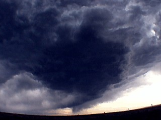
The picture above shows a clockwise rotating supercell in an high-based line segment on May 21, 2002 near Casper, Wyoming where winds at the surface were south, but stronger from the east-southeast aloft ahead and north of the axis of a highly negative-tilted upper trough. The storm was also timelapsed and clearly showed a clockwise spin (view is to the north and you can even see some clear air wrapping from the left and into the north side of the mesocyclone).
Such a storm can also be non-intuitively dangerous, such as the dangerous hail and precipitation being SOUTH of the storm, not NORTH of it as with a cyclonic supercell. Many hail events and chasers getting caught off guard have been associated with anti-cyclonic supercells because while it is quite possible for a LEFT moving supercell to split away from the southern (right moving) split and become the main supercell, akin to the RIGHT split becoming the main "show" we chasers are so used to.
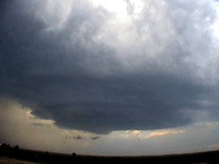
A rather interesting example of an "anti-supercell", or a supercell that roatates CLOCKWISE, occurred on May 26, 2004 near Altus, Oklahoma and a picture of the storm is shown below...
You may see that this picture resembles an "Australian supercell" or "mirror image" but it's not, despite its impressive structure too. The view is to the west and clearly you can see that the inflow region is to the RIGHT, and precipitation to the LEFT (a mirror image or a "regular" supercell). Inflow was from the northeast into the storm on the NE side of it, which bent to a north wind, then flowed westward into the "notch" and vault of the storm (between the precip and RF base, to the LEFT, not the RIGHT in this picture). Note even the updraft is "leaning" more to the left with height, so bulk / storm-relative shear may even be reversed (stronger wind at surface than aloft) due to the fast NNE motion of the cell.
If you look closely, the RFD can even be seen cutting under the updraft from the left, then towards the photographer in the lower center of the updraft, that is clockwise. Also note the scud, hinting wall cloud development, is also angled towards the precipitation to the left, opposite of what we are used to seeing with a cyclonic supercell.
Only 1 to 2 percent of supercell storms are anticyclonic (in the southern hemisphere, the opposite applies, where counter clockwise supercells are rare opposed to clockwise ones). This is due to normal verring / backing patterns of winds aloft. In the USA, a southeast surface winds veers southwest aloft, encouraging a counter clockwise spin on MOST supercells. In Australia, a northeast wind at the surface gives way to a northwest wind aloft, hence "backing" winds with height, so MOST supercells normally rotate clockwise there. The coriolis force does not affect mesoscale rotations too much if at all. Aside from this, boundary interactions and / or deviant motion can cause such "opposite" turning supercell rareties.
Conditions (hodographs) this day favored splitting storms, and this one was anchored along a boundary that was moving rapidly northward. The southern split dissapated quickly, and was moving southeast at about 10-15 MPH. This left split here, was moving NNE at nearly 60 MPH! The main speed vector was ENE at about 20-25 MPH that day based on SPC text and hodographs.
A supercell storm moving NNE at that speed and so deviant from the main "steering" flow will experience totally the opposite storm-relative helicity a right-moving supercell would "feel". With such high "negative" helicities the low level meso would rotate anticyclonically.
The example above did produce a small funnel, clockwise rotating, but that's about it. Much attention was owed to the "stacked plate" structure despite it rotating clockwise.
Remember, do NOT try to go south of an anticyclonic supercell storm to check the "right split" as the WORST hail is SOUTH if the supercell's updraft and NOT NORTH of it (the storm shown above in Altus had hail reported to 3.5 inches) ;-)
Chris C - KG4PJN
I figured I would post this since I find some rare supercell variants quite interesting and less understood than their normal "counterparts". It is almost a rule of thumb that a splitting storm will eventually have two distinct storms in an ideal environment, the left split moving to the left of the mean wind vector, and the right split moving to the right. This will be on each side of the axis of that wind vector. For example, lets say storm motion is due east. A left split therefore may move to the NE and accelerate while a right split will move SE and slow down. It almost seems that the storms just after splitting will create a vortex "couplet", where the left storm to the north tends to spin clockwise, while the southern right split compliments with a counter-clockwise spin (N Hemisphere).
Normally, in the real world, the southern split often has better inflow and theta-e air to work with and ingest, and often chokes off inflow to the storm behind it (the left split) thus killing it (or the left split becomes cutoff from the surface winds in the presence of elevating over a boundary that may be present). Most of the severe weather then occurs with the southern storm, or the right split.
Now, what happens when some special conditions exist, let's say the boundary north of both storms when the "split" ocurred is moving northward fast and the northern storm becomes "anchored" on it. Now the right split may either survive, or weaken in the presence of a stronger cap to the south and decreased moisture convergenace along the boundary, which the southern storm is now well detached from. In this case, given the northern storm gets far enough away from the right split, then THAT storm will become the main supercell. If there is good inflow into it, say from the east, and theta-e is in place, and moving left of the mean wind, this developing supercell may indeed rotate clockwise, and become a rarity in itself aside from supercells we are used to dealing with.
Another and even more interesting clockwise supercell may form in air where the winds "back" with height, rather than "veer". There have been examples of low-topped CLOCKWISE supercells forming in unstable air behind a cold front, in California during the early spring to be exact, where a strong NW wind existed at the surface but a SW wind was aloft, with plenty of cold-cumulus type instability providing low topped convection. This is rarely to occur in the plains in the spring, but I would not rule it out, because it can and has occurred on special occasions.
The picture above shows a clockwise rotating supercell in an high-based line segment on May 21, 2002 near Casper, Wyoming where winds at the surface were south, but stronger from the east-southeast aloft ahead and north of the axis of a highly negative-tilted upper trough. The storm was also timelapsed and clearly showed a clockwise spin (view is to the north and you can even see some clear air wrapping from the left and into the north side of the mesocyclone).
Such a storm can also be non-intuitively dangerous, such as the dangerous hail and precipitation being SOUTH of the storm, not NORTH of it as with a cyclonic supercell. Many hail events and chasers getting caught off guard have been associated with anti-cyclonic supercells because while it is quite possible for a LEFT moving supercell to split away from the southern (right moving) split and become the main supercell, akin to the RIGHT split becoming the main "show" we chasers are so used to.
A rather interesting example of an "anti-supercell", or a supercell that roatates CLOCKWISE, occurred on May 26, 2004 near Altus, Oklahoma and a picture of the storm is shown below...
You may see that this picture resembles an "Australian supercell" or "mirror image" but it's not, despite its impressive structure too. The view is to the west and clearly you can see that the inflow region is to the RIGHT, and precipitation to the LEFT (a mirror image or a "regular" supercell). Inflow was from the northeast into the storm on the NE side of it, which bent to a north wind, then flowed westward into the "notch" and vault of the storm (between the precip and RF base, to the LEFT, not the RIGHT in this picture). Note even the updraft is "leaning" more to the left with height, so bulk / storm-relative shear may even be reversed (stronger wind at surface than aloft) due to the fast NNE motion of the cell.
If you look closely, the RFD can even be seen cutting under the updraft from the left, then towards the photographer in the lower center of the updraft, that is clockwise. Also note the scud, hinting wall cloud development, is also angled towards the precipitation to the left, opposite of what we are used to seeing with a cyclonic supercell.
Only 1 to 2 percent of supercell storms are anticyclonic (in the southern hemisphere, the opposite applies, where counter clockwise supercells are rare opposed to clockwise ones). This is due to normal verring / backing patterns of winds aloft. In the USA, a southeast surface winds veers southwest aloft, encouraging a counter clockwise spin on MOST supercells. In Australia, a northeast wind at the surface gives way to a northwest wind aloft, hence "backing" winds with height, so MOST supercells normally rotate clockwise there. The coriolis force does not affect mesoscale rotations too much if at all. Aside from this, boundary interactions and / or deviant motion can cause such "opposite" turning supercell rareties.
Conditions (hodographs) this day favored splitting storms, and this one was anchored along a boundary that was moving rapidly northward. The southern split dissapated quickly, and was moving southeast at about 10-15 MPH. This left split here, was moving NNE at nearly 60 MPH! The main speed vector was ENE at about 20-25 MPH that day based on SPC text and hodographs.
A supercell storm moving NNE at that speed and so deviant from the main "steering" flow will experience totally the opposite storm-relative helicity a right-moving supercell would "feel". With such high "negative" helicities the low level meso would rotate anticyclonically.
The example above did produce a small funnel, clockwise rotating, but that's about it. Much attention was owed to the "stacked plate" structure despite it rotating clockwise.
Remember, do NOT try to go south of an anticyclonic supercell storm to check the "right split" as the WORST hail is SOUTH if the supercell's updraft and NOT NORTH of it (the storm shown above in Altus had hail reported to 3.5 inches) ;-)
Chris C - KG4PJN