John Erwin
EF5
09/16/06 DISC: North-central U.S. *rescued*
**rescued post**
Andy Wehrle
Location: Green Bay, WI
Posted: Sat Sep 16, 2006 2:15 pm
Post non-forecast/1st-hand report related comments about today's event here.
For those who were noting the earlier problems with the Sioux Falls radar, here is the explanation:
http://www.crh.noaa.gov/crnews/display_story.php?wfo=fsd&storyid=2907&source=0
Amos Magliocco
Location: Denton, Texas
Posted: Sat Sep 16, 2006 2:28 pm
Ah, my bad. Posted those others in the FCST thread in my rush to figure out what was happening. I don't see a delete button or I would remove them.
Rean Clover wrote: The Sioux Falls Radar is up. On the main page the black box says "radar not available", but if you click on it, it will bring the radar page up. It appears to be working and current.
Rean, when you say, "click on it," do you mean the black box or is there another link you're using. I'm still having no luck. What's the timestamp on the image you have? This is getting tricky because there's already a severe storm in the FSD CWA, barely visible on the Aberdeen radar extended, and with the warning polygon showing up on GRLevel3 (but without reflectivity data).
Just found this on the FSD site:
http://www.crh.noaa.gov/crnews/display_story.php?wfo=fsd&storyid=2907&source=0
"NWS Sioux Falls radar down for repair
The National Weather Service doppler radar in Sioux Falls, SD...which covers portions of southeast South Dakota, southwest Minnesota, northwest Iowa, and northeast Nebraska...is down for unscheduled maintenance. Electronics techinicians are working on the problem, and it now appears the radar may have taken a lightning strike during early morning thunderstorms. We hope to have it restored ASAP, and sincerely apologize for the inconvenience.
Alternatives radars which cover the NWS Sioux Falls County Warning Area:
Java-enhanced version (high-speed connection recommended):
* Rapid City, SD
* Aberdeen, SD
* Twin Cities/Chanhassen, MN
* Des Moines, IA
* Omaha/Valley, NE
* North Platte, NE
Standard version (better for dial-up/lower speed connections):
* Rapid City, SD
* Aberdeen, SD
* Twin Cities/Chanhassen, MN
* Des Moines, IA
* Omaha/Valley, NE
* North Platte, NE"
Andy Wehrle
Location: Green Bay, WI
Posted: Sat Sep 16, 2006 5:15 pm
Another possible NOAA problem I've noticed today...anyone think the LSRs are not getting through to SPC, or the WFOs are not issuing them for some reason? Given the number of "Trained spotters reported a tornado...", "law enforcement reported a tornado..." etc phrases in the severe weather statements, I have to think there have been more than the 2 tornado reports on SPC's climo page.
Sam Sagnella
Posted: Sat Sep 16, 2006 8:40 pm
Andy Wehrle wrote: Another possible NOAA problem I've noticed today...anyone think the LSRs are not getting through to SPC, or the WFOs are not issuing them for some reason? Given the number of "Trained spotters reported a tornado...", "law enforcement reported a tornado..." etc phrases in the severe weather statements, I have to think there have been more than the 2 tornado reports on SPC's climo page.
I've noticed that too, although WFO Sioux Falls has been issuing regular updates to its "summary" LSR over the past several hours. The most recent version, as of this writing, has ten tornado reports (duplicates yet to be weeded-out). I'm waiting for Omaha to issue an updated statement on the tornadic activity they've had in the metro area in the past hour.
Jason Bolt
Location: Memphis, TN
Posted: Sun Sep 17, 2006 12:44 pm
There were two nice videos highlighted on the weather channel. Anyone here shoot them?
Tony Lyza
Location: Schererville, Indiana
Posted: Sun Sep 17, 2006 1:01 pm
A ten-year-old girl was killed late last night in Rogers, Hennepin County, MN, when a house collapsed on her.
http://wcco.com/local/local_story_260101356.html
rdale
Location: Lansing, MI
Posted: Sun Sep 17, 2006 1:39 pm
Tony Lyza wrote: The storm had a TOR, but apparently, the tornado hit right as or before the sirens sounded, again highlighting the need for NWRs.
According to the article, the damage occurred around 10pm and there was no tornado warning in effect or even issued remotely around then.
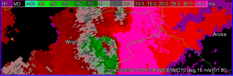
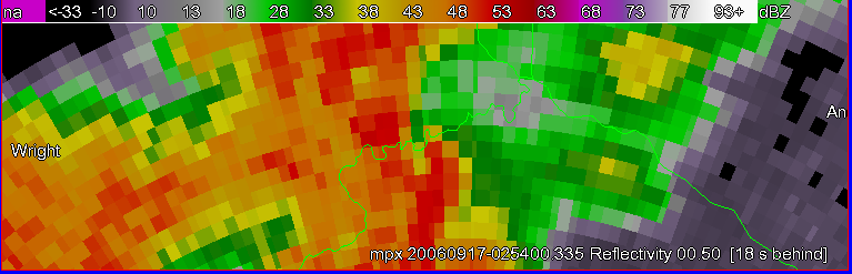
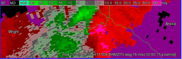
Strangely enough, MPX has a page telling how strong rotation is (100kts) at the time, yet no warning. http://www.crh.noaa.gov/crnews/display_story.php?wfo=mpx&storyid=3690&source=0
Tony Lyza
Location: Schererville, Indiana
Posted: Sun Sep 17, 2006 1:42 pm
rdale wrote: Tony Lyza wrote: The storm had a TOR, but apparently, the tornado hit right as or before the sirens sounded, again highlighting the need for NWRs.
According to the article, the damage occurred around 10pm and there was no tornado warning in effect at that time.
I know. I realized my mistake on another message board. I'm going to edit my last post.
Also, MPX came out with a statement calling the Rogers damage "tremendous" and indicating there was 100kt of shear with the storm as it struck the town.
http://www.crh.noaa.gov/crnews/display_story.php?wfo=mpx&storyid=3690&source=0
Scott Olson
Moderator
Location: Brookings, South Dakota
Posted: Sun Sep 17, 2006 1:56 pm
Damage to farmstead 3-4mi NNE of Colton:


More at: http://www.axisofnature.com/WordPress/index.php
Bill Doms
Location: Central Minnesota
Posted: Sun Sep 17, 2006 2:09 pm
http://www.startribune.com/127/story/682389.html
A little more info on the Rogers situation with damage photos from last night.
This is about 15 miles east of where I live. After getting home from chasing SD yesterday, was actually taking pics of the back of the updraft as the cell moved over the northern metro area. Went out this morning and appears the damage path started out in a corn field about 1.5 miles south of the I94/241 junction then moved northeast over I94 over the northern end of Rogers, over 101 at the highschool, then continued to cross the Mississippi River just to the east of the city of Dayton where I could not follow the path. I'll post some pics later of the initial damage. The damage apeared to be F0/F1 on west side of I94. The development where the most damage is has been sealed by LE for obvious reasons. Devistating is an accurate description.
HAltschule
Location: Albany, New York
Posted: Sun Sep 17, 2006 3:19 pm
The damage in Rogers, MN has been confirmed as an F2 tornado with 100 mph winds. Path length so far is 6 miles long. Survey will continue tomorrow into the next county to see if the tornado continued into adjacent counties...which would of course increase the path length.
Chris Carlson
Location: Twin Cities, Minnesota
Posted: Sun Sep 17, 2006 4:46 pm
Man, that Rogers tornado was too close for my taste. According to NWS, TOR was 3.5 west of downtown Rogers. I'm only 5.0 miles away. 1.5 miles isn't that much. I drove around Rogers just after it hit and it looked like a warzone.
Bill Doms
Location: Central Minnesota
Posted: Sun Sep 17, 2006 6:59 pm
Added some photos of the fatal Rogers, MN F2 damage path from the point of initial touchdown to where it entered the first heavily populated area. This is a MAJOR suburb of the Minneapolis metro area. Very fortunate aside from the one little girl who was killed, there were not more.

http://www.mnwxchaser.com/06sept16.html
**rescued post**
Andy Wehrle
Location: Green Bay, WI
Posted: Sat Sep 16, 2006 2:15 pm
Post non-forecast/1st-hand report related comments about today's event here.
For those who were noting the earlier problems with the Sioux Falls radar, here is the explanation:
http://www.crh.noaa.gov/crnews/display_story.php?wfo=fsd&storyid=2907&source=0
Amos Magliocco
Location: Denton, Texas
Posted: Sat Sep 16, 2006 2:28 pm
Ah, my bad. Posted those others in the FCST thread in my rush to figure out what was happening. I don't see a delete button or I would remove them.
Rean Clover wrote: The Sioux Falls Radar is up. On the main page the black box says "radar not available", but if you click on it, it will bring the radar page up. It appears to be working and current.
Rean, when you say, "click on it," do you mean the black box or is there another link you're using. I'm still having no luck. What's the timestamp on the image you have? This is getting tricky because there's already a severe storm in the FSD CWA, barely visible on the Aberdeen radar extended, and with the warning polygon showing up on GRLevel3 (but without reflectivity data).
Just found this on the FSD site:
http://www.crh.noaa.gov/crnews/display_story.php?wfo=fsd&storyid=2907&source=0
"NWS Sioux Falls radar down for repair
The National Weather Service doppler radar in Sioux Falls, SD...which covers portions of southeast South Dakota, southwest Minnesota, northwest Iowa, and northeast Nebraska...is down for unscheduled maintenance. Electronics techinicians are working on the problem, and it now appears the radar may have taken a lightning strike during early morning thunderstorms. We hope to have it restored ASAP, and sincerely apologize for the inconvenience.
Alternatives radars which cover the NWS Sioux Falls County Warning Area:
Java-enhanced version (high-speed connection recommended):
* Rapid City, SD
* Aberdeen, SD
* Twin Cities/Chanhassen, MN
* Des Moines, IA
* Omaha/Valley, NE
* North Platte, NE
Standard version (better for dial-up/lower speed connections):
* Rapid City, SD
* Aberdeen, SD
* Twin Cities/Chanhassen, MN
* Des Moines, IA
* Omaha/Valley, NE
* North Platte, NE"
Andy Wehrle
Location: Green Bay, WI
Posted: Sat Sep 16, 2006 5:15 pm
Another possible NOAA problem I've noticed today...anyone think the LSRs are not getting through to SPC, or the WFOs are not issuing them for some reason? Given the number of "Trained spotters reported a tornado...", "law enforcement reported a tornado..." etc phrases in the severe weather statements, I have to think there have been more than the 2 tornado reports on SPC's climo page.
Sam Sagnella
Posted: Sat Sep 16, 2006 8:40 pm
Andy Wehrle wrote: Another possible NOAA problem I've noticed today...anyone think the LSRs are not getting through to SPC, or the WFOs are not issuing them for some reason? Given the number of "Trained spotters reported a tornado...", "law enforcement reported a tornado..." etc phrases in the severe weather statements, I have to think there have been more than the 2 tornado reports on SPC's climo page.
I've noticed that too, although WFO Sioux Falls has been issuing regular updates to its "summary" LSR over the past several hours. The most recent version, as of this writing, has ten tornado reports (duplicates yet to be weeded-out). I'm waiting for Omaha to issue an updated statement on the tornadic activity they've had in the metro area in the past hour.
Jason Bolt
Location: Memphis, TN
Posted: Sun Sep 17, 2006 12:44 pm
There were two nice videos highlighted on the weather channel. Anyone here shoot them?
Tony Lyza
Location: Schererville, Indiana
Posted: Sun Sep 17, 2006 1:01 pm
A ten-year-old girl was killed late last night in Rogers, Hennepin County, MN, when a house collapsed on her.
http://wcco.com/local/local_story_260101356.html
rdale
Location: Lansing, MI
Posted: Sun Sep 17, 2006 1:39 pm
Tony Lyza wrote: The storm had a TOR, but apparently, the tornado hit right as or before the sirens sounded, again highlighting the need for NWRs.
According to the article, the damage occurred around 10pm and there was no tornado warning in effect or even issued remotely around then.
Strangely enough, MPX has a page telling how strong rotation is (100kts) at the time, yet no warning. http://www.crh.noaa.gov/crnews/display_story.php?wfo=mpx&storyid=3690&source=0
Tony Lyza
Location: Schererville, Indiana
Posted: Sun Sep 17, 2006 1:42 pm
rdale wrote: Tony Lyza wrote: The storm had a TOR, but apparently, the tornado hit right as or before the sirens sounded, again highlighting the need for NWRs.
According to the article, the damage occurred around 10pm and there was no tornado warning in effect at that time.
I know. I realized my mistake on another message board. I'm going to edit my last post.
Also, MPX came out with a statement calling the Rogers damage "tremendous" and indicating there was 100kt of shear with the storm as it struck the town.
http://www.crh.noaa.gov/crnews/display_story.php?wfo=mpx&storyid=3690&source=0
Scott Olson
Moderator
Location: Brookings, South Dakota
Posted: Sun Sep 17, 2006 1:56 pm
Damage to farmstead 3-4mi NNE of Colton:
More at: http://www.axisofnature.com/WordPress/index.php
Bill Doms
Location: Central Minnesota
Posted: Sun Sep 17, 2006 2:09 pm
http://www.startribune.com/127/story/682389.html
A little more info on the Rogers situation with damage photos from last night.
This is about 15 miles east of where I live. After getting home from chasing SD yesterday, was actually taking pics of the back of the updraft as the cell moved over the northern metro area. Went out this morning and appears the damage path started out in a corn field about 1.5 miles south of the I94/241 junction then moved northeast over I94 over the northern end of Rogers, over 101 at the highschool, then continued to cross the Mississippi River just to the east of the city of Dayton where I could not follow the path. I'll post some pics later of the initial damage. The damage apeared to be F0/F1 on west side of I94. The development where the most damage is has been sealed by LE for obvious reasons. Devistating is an accurate description.
HAltschule
Location: Albany, New York
Posted: Sun Sep 17, 2006 3:19 pm
The damage in Rogers, MN has been confirmed as an F2 tornado with 100 mph winds. Path length so far is 6 miles long. Survey will continue tomorrow into the next county to see if the tornado continued into adjacent counties...which would of course increase the path length.
Chris Carlson
Location: Twin Cities, Minnesota
Posted: Sun Sep 17, 2006 4:46 pm
Man, that Rogers tornado was too close for my taste. According to NWS, TOR was 3.5 west of downtown Rogers. I'm only 5.0 miles away. 1.5 miles isn't that much. I drove around Rogers just after it hit and it looked like a warzone.
Bill Doms
Location: Central Minnesota
Posted: Sun Sep 17, 2006 6:59 pm
Added some photos of the fatal Rogers, MN F2 damage path from the point of initial touchdown to where it entered the first heavily populated area. This is a MAJOR suburb of the Minneapolis metro area. Very fortunate aside from the one little girl who was killed, there were not more.
http://www.mnwxchaser.com/06sept16.html