5/25/05 REPORTS: NM, TX

Status
Not open for further replies.
Joined
Mar 2, 2004
Messages
2,381
Location
Northern Colorado
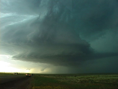
What a great day in New Mexico! This was actually my first ever chase in New Mexico and boy was I welcomed with open arms! We began our day casually from Lamar as we were originally going to visit the volcano, but towers developing to our south and west and we took off after them. We were watching the southern most storm when we got treated to the storm to the north...

A nuclear explosion; towers went up so fast it looked as if the military was testing nuclear weapons. This thing went up monsterously fast; almost like live time-laspe. Chris Collura shot a complete time lapse of it which will likely be the time lapse of the year!

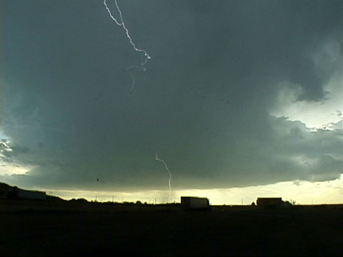
We stayed with this storm as it tried to get organized; damn nearly pulled a wall cloud but outflow cut it off. We danced with it for a bit as other chasers began to flood the area (YES, WE WERE THEIR FIRST :lol: ); the storm tried a couple times to reorganize, but to no avail. We fired south and east where Jon and I split from the gang and headed west along I-40 hoping to intercept some sunset lightning. Jon was able to get a couple shots before rain overtook us. We then headed to Las Vegas!

And to top off the night, we ended up knocking a Comfort Inn for dirt cheap; getting the LAST room in the hotel... we ate at the local Wendy's which was EASILY the BEST cheeseburger I've ever eaten at a Wendy's.

A great day to share with Jeff Gammons, Chris Collura, Kersten McClung, Scott Blair, and Scott Eubanks! Definately made up for yesterday's frustrations with what could easily be called the most incredible tower growth ever seen! That thing went up like a bomb! Incredible shots to be had which I'll post online shortly!

Goodnight from Vegas.. the OTHER Vegas! :)
 
I played around with that stuff around Midland and Big Spring, TX and then brought it all home with me and it's still here! I can't make it go away! :lol:

Didn't see much interesting but got cored once and felt like I was in a hurricane! Was a nice change from the 100 degree temps just to get out. Was treated almost all evening to continuous CGs. At one point I was on a back road between two fields near Lamesa and the things just kept zapping all around me. I got in the chase van and was shooting out the window and one hit in the field right next to me. The discharge caused my camera to reset. I went back and looked and there was a bright flash and then nothing, darn it. Still got tons of great CG video!

EDIT:

A couple of lightning shots:

[Broken External Image]:http://www.wx5tvs.com/chasephotos/2005/2005pics/2005pics/2005.05.26/lamesalightning1.jpg

[Broken External Image]:http://www.wx5tvs.com/chasephotos/2005/2005pics/2005pics/2005.05.26/wellmanlightning1.jpg

and a little bit of video:

2:34 9.71MB WMV

http://www.wx5tvs.com/chasephotos/2005/200.../2005.05.26.wmv
 
Storm north of Santa Rosa
temp052505beautiful2.jpg


LP storm to our west
temp052505lplater2.jpg


This is an odd feature. May have been a landspout (see below) Too far to verify rotation
temp052505landspout2.jpg


May 25, 2005 Storm Chase New Mexico

Amazing supercell, hail and lightning (?landspout)

I had very low expectations for the day. Upper level support was poor along with low dewpoints and only a small area of predicted backing in the winds. A cold front was moving south into New Mexico from Colorado. My initial target was in the Capulin area of New Mexico, but I revised it southward as the front moved south. Jason and I ate a quick breakfast in Lamar and headed west and south. I saw more chasers than residents while driving through Lamar. We headed south of 109, then used some back roads to get to the Capulin area. This is beautiful terrain with mesas, scrub and abundant wildflowers. The volcano vanished into the clouds. South of Clayton, we broke into sunshine and warmer temperatures. We were past the front but still in northwesterly winds. To the west, storms were forming a long the mountains in a north south line. Road options were difficult but I did want to target the most southerly storm. With the poor outlook, we drove leisurely with many stops to photograph wildflowers and landscapes. At 4:20 PM MDT, we found some especially pretty ones north of Nara Visa. We dropped south on 402 and checked data in Logan. The storms to the west were not impressive and the northerly ones were being undercut by the approaching front. I almost considered ending the chase bit figured the southernmost storm would at least be photogenic. We headed toward Tucumcari, then west on 54. The most southern storm began to look more organized on the Baron Threatnet and was beginning to turn right. The large storm was north of Santa Rosa in an area with no roads. At 5:45PM, we could see the crisp updraft. Another smaller storm was developing to our west. The base of the larger storm became visible. Rotation was indicated on the Baron system. A small storm directly to our west was exploding. We noticed a dark column under the rainfree base at 5:45PM. This feature was persistent for a couple of minutes before vanishing. It was in the correct place for a tornado. When it vanished, it was not replaced by multiple columns nor did it expand which would indicate rain columns. We were too far to confirm rotation. The northern and larger storm was also organizing. A clear slot was visible. Rotation was increasing as shown on the Baron system. We pulled off 54 at the Cuervo exit and watched the LPish storm to our west and the larger storm to the northwest. A wall cloud developed at 6:14PM while the Baron was showing 113 mph shear. There was inflow with gusts to approximately 30 mph. Unfortunately, the storm to our west (and south of the larger storm) was growing and cutting off the larger one. The wall cloud soon vanished. The storm to the west had a “stack of platesâ€￾ appearance with midlevel inflow jets. The storms were becoming part of a larger amalgamation of cores north and over the road. The storm that was originally to our west, was now moving southeast near 85. Behind it to the north were multiple cores. There were also a couple of storms in an east west orientation near Tucumcari. We drove west, then southeast on 85. At one point, we were between several cores. The edges of the storms towered above us. Eventually, we were hit the hail and wind as we passed along the western core of the southernmost storm. The structure was beautiful and we stopped for lighting and other images. In Fort Sumner, I watched debris and tumble weeds blow through town. Jason decided to wait and take lightning images while I continued east on 60. I am now in Clovis, New Mexico.

More IMAGES

LP storm to the west
http://www.harkphoto.com/temp052505lpstorm.jpg

Earlier image of storm north of Santa Roas
http://www.harkphoto.com/temp052505northstorm.jpg

Debris and tumble weed blowing in the street
http://www.harkphoto.com/tempdebris052505.jpg

Hail shafts between cores
http://www.harkphoto.com/temp052505shaft.jpg

Looking west on 60/84
http://www.harkphoto.com/temp052505nightstorm.jpg

Jason Persoff, M.D. (with Weathervine group in the background) at diner in Lamar. All the chasers were put in one section.
http://www.harkphoto.com/temp052505chaserbreakfast.jpg


Bill Hark
[/img]
 
Had a good day in NM yesterday. Started out in Burlinton CO, where it was in the low 50s... Got to Clayton NM early afternoon, low 80s. There was chaser convergence at the Clayton library, met allot of good folks. Decided to head W along 56. Cought a nice LP cell 10 - 15 mi NE of Roy.

http://i6.photobucket.com/albums/y239/fend...dy/IMG_0548.jpg
http://i6.photobucket.com/albums/y239/fend...dy/IMG_0544.jpg

Followed that storm on some muddy sticky NM back roads and got held up by the bovine congestus...arg!
http://i6.photobucket.com/albums/y239/fend...dy/IMG_0556.jpg

Got back on solid ground with no cows and went south on 39 and saw this:
http://i6.photobucket.com/albums/y239/fend...dy/IMG_0558.jpg

All in all not a bad day.
 
May 25 - Today was another great chase day with three supercells intercepted. We left Lamar, Colorado and headed southwest through Trinidad, and took Interstate 25 out of the mountains and headed south. We entered the warm sector ahead of a cold front near Raton, New Mexico and stopped to observe a developing LP supercell southwest of Springer, New Mexico. This storm was a well-developed LP supercell storm, but did not get very well organized. A new storm EXPLOSIVELY developed ahead of the cold front to the northeast of the LP storm and went from fair-weather cumulus to a full-fledged classic supercell in only a half hours time! This storm wrapped up and had some of the most rock-hard "cauliflower" updrafts I have ever seen. The storm became undercut by the cold front but persisted for a while as it evolved to an LP storm, became elevated, and dissapated. Attention shifted towards storms near Tucemcari, New Mexico. Southeast of this area, another supercell storm explosively developed and became a mature storm in about twenty minutes. This supercell also became undercut by the cold air surging southward, but turned right maintained supercell status (classic and LP) for some time. Giant hail (nearly baseball sized) was observed by Chris Collura and Scott Blair with this storm along with incredible storm structure northwest of Logan, New Mexico. Hail was encountered again at a gas station, but smaller, in Logan. This was the last storm of the day, so we headed west into Clovis, New Mexico for the night.

New Mexico Timelapse Segment: - Windows Media Player
http://www.stormvideographer.com/weathervi...pringer_win.wmv


springer1.jpg


springer2.jpg


springer3.jpg


springer4.jpg
 
Status
Not open for further replies.
Back
Top